Record lows (and highs) possible in Alabama
It’s going to feel more like January than October across Alabama for the next two days.
High temperatures will only make it into the 50s across most of Alabama today as an arctic airmass takes hold across the state.
There are some freeze warnings in effect through part of Tuesday morning, and more will go into effect tonight. The Alabama counties in purple will be under freeze warnings tonight:
Freeze warnings will go into effect Tuesday night for the Alabama counties in purple.
But there’s a chilly day to get through first. Here are the forecast high temperatures for Tuesday:
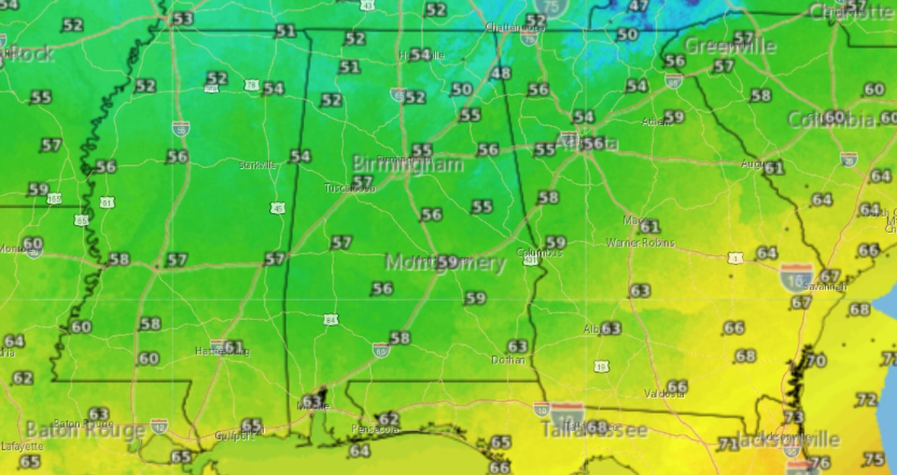
Temperatures on Tuesday may not make it out of the 50s across much of Alabama.
In fact, it may be cool enough today to set record low high temperatures, according to forecasters.
More records could fall overnight — from Tuesday night into Wednesday morning — and freeze warnings will be in effect for a large part of the state. (The forecast for Tuesday night into Wednesday morning is at the top of this post.)
More cold-for-October temperatures are in store for Wednesday and Wednesday night, and more record low temperatures will be possible, according to forecasters.
Here’s the low temperature forecast for Wednesday night/Thursday morning:
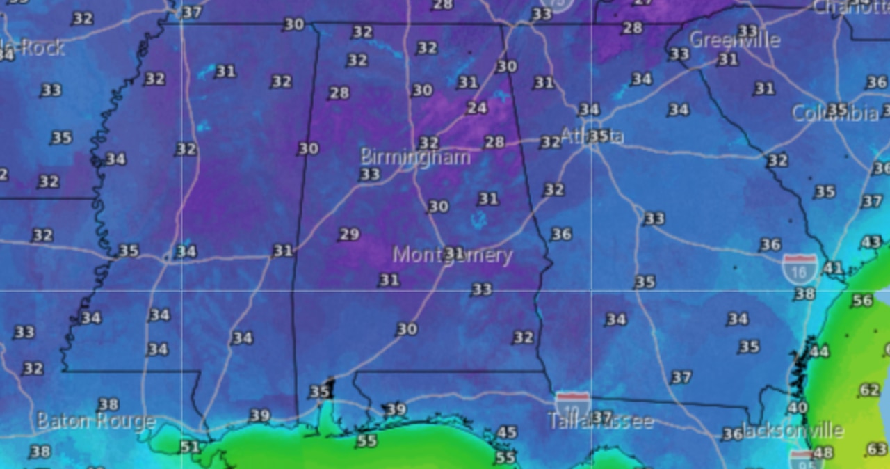
More below-freezing temperatures will be possible by Thursday morning.
Here’s what to expect across the state:
NORTH ALABAMA
* Freeze warning for all of north Alabama until 9 a.m. today (Tuesday) and from 1 a.m. until 9 a.m. Wednesday.
Counties in both warnings are Lauderdale, Colbert, Franklin, Lawrence, Limestone, Madison, Morgan, Marshall, Jackson, DeKalb and Cullman.
Temperatures this morning could range between 29 to 32 degrees. It will be even colder tonight, with lows expected to be between 26 and 30 degrees, according to the National Weather Service in Huntsville.
CENTRAL ALABAMA
* Freeze warning until 9 a.m. today (Tuesday) for Marion, Lamar, Fayette, Winston, Walker, Blount, Etowah, Calhoun, Cherokee, Cleburne, Jefferson and St. Clair counties.
* Freeze warning from midnight tonight until 9 a.m. Wednesday for Pickens, Tuscaloosa, Shelby, Talladega, Clay, Randolph, Sumter, Greene, Hale, Perry, Bibb, Chilton, Coosa, Tallapoosa, Chambers, Marengo, Dallas, Autauga-Lowndes-Elmore-Montgomery-Macon-Bullock-Lee-Russell-Pike, Barbour, Marion, Lamar, Fayette, Winston, Walker, Blount, Etowah, Calhoun, Cherokee, Cleburne, Jefferson and St. Clair counties.
* Freeze watch for the same counties listed above from Wednesday night through Thursday morning.
Temperatures from Tuesday night into Wednesday morning could be as low as 26 degrees. Wednesday night into Thursday night could see lows fall as far as 24 degrees, according to the National Weather Service in Birmingham.
SOUTH ALABAMA
* Freeze warning from 1 a.m. until 8 a.m. Wednesday for Choctaw, Washington, Clarke, Wilcox, Monroe, Conecuh, Butler, Crenshaw, Escambia, Covington and central and inland Mobile and Baldwin counties.
* Freeze watch from Wednesday night into Thursday morning for Choctaw, Washington, Clarke, Wilcox, Monroe, Conecuh, Butler and Crenshaw counties.
RECORD WATCH
Could there be some record cold temps? It’s possible. Here is a look at the record lows for some Alabama cities through Oct. 20:
BIRMINGHAM
Oct. 18: 31 in 1948
Oct. 19: 29 in 1948
Oct. 20: 32 in 1964
DAUPHIN ISLAND
Oct. 18: 49 in 2009
Oct. 19: 46 in 2009
Oct. 20: 42 in 1989
DOTHAN
Oct. 18: 36 in 2001
Oct. 19: 37 in 2009
Oct. 20: 34 in 1989
FORT PAYNE
Oct. 18: 32 in 2009
Oct. 19: 38 in 2015
Oct. 20: 39 in 2008
HIGHLAND HOME
Oct. 18: 43 in 2015
Oct. 19: 42 in 2015
Oct. 20: 42 in 2015
HUNTSVILLE
Oct. 18: 28 in 1943
Oct. 19: 25 in 1948
Oct. 20: 30 in 1925
MOBILE
Oct. 18: 35 in 1948
Oct. 19: 38 in 1989
Oct. 20: 33 in 1989
MONTGOMERY
Oct. 18: 35 in 2001
Oct. 19: 34 in 1948
Oct. 20: 32 in 1989
MUSCLE SHOALS
Oct. 18: 29 in 1948
Oct. 19: 28 in 1948
Oct. 20: 28 in 1917
SELMA
Oct. 18: 34 in 1943
Oct. 19: 34 in 1948
Oct. 20: 35 in 1989
TROY
Oct. 18: 31 in 1943
Oct. 19: 37 in 1981
Oct. 20: 32 in 1989
TUSCALOOSA
Oct. 18: 30 in 1948
Oct. 19: 28 in 1948
Oct. 20: 32 in 1989