Deadly Alabama tornado travelled a 77-mile path, one of the longest in state history
The National Weather Service has spent the past few days tracing the path of Alabama’s deadliest tornado since 2019.
Meteorologists have rated the tornado that took seven lives in Autauga County on Jan. 12 an EF-3, with top winds estimated at 150 mph in spots along its path.
The Old Kingston-Lake Martin tornado was one of 14 tornadoes that hit Alabama on Jan. 12. Nine were in central Alabama, one was in north Alabama, one was in southeast Alabama and three were in southwest Alabama.
See also:
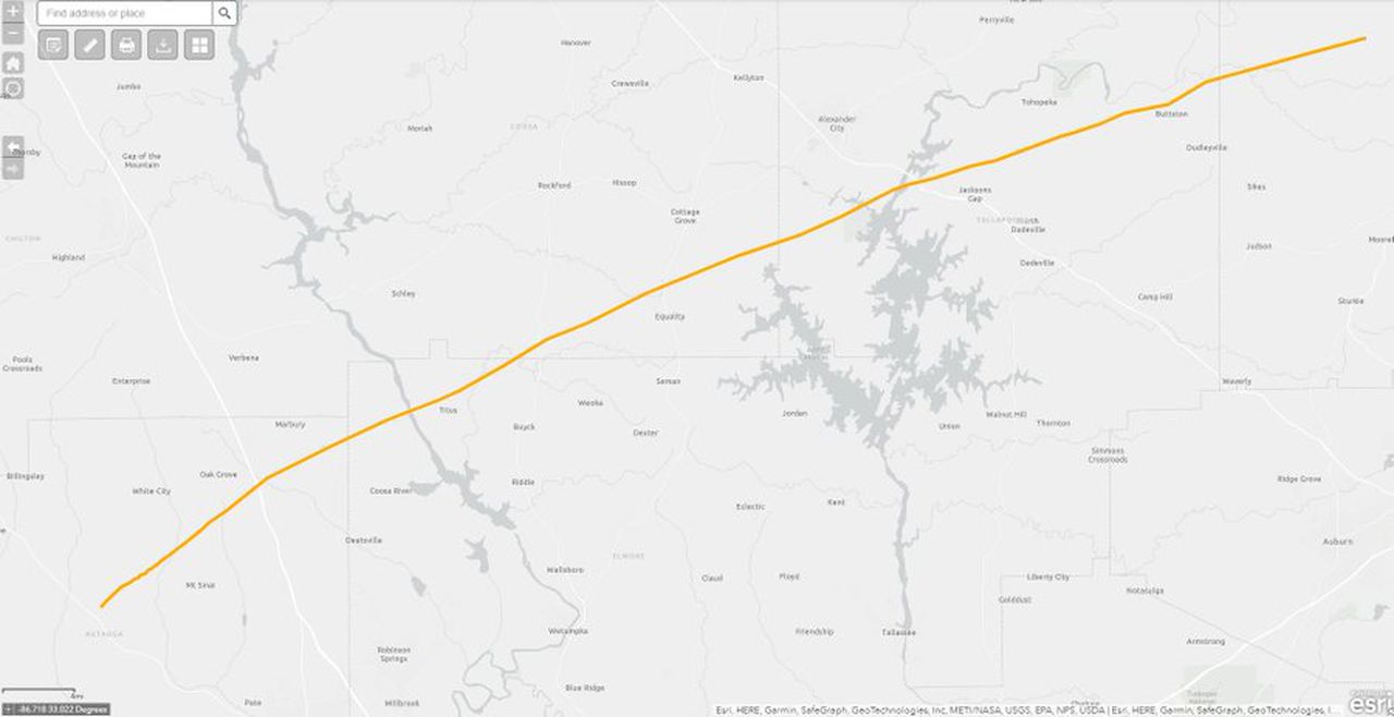
The Autauga tornado was a dreaded long-track tornado, with a path that was 76.67 miles long.
The tornado is one of the 10 longest tornado tracks on record in Alabama, coming in at No. 9 on the list.
According to the National Weather Service in Birmingham, the Autauga tornado was on the ground for an hour and 20 minutes.
The tornado killed seven people and injured several others and caused widespread damage along its long path.
At its peak it was 1,500 yards wide.
The tornado that killed seven people in Autauga County had a path that was more than 76 miles long and stretched through several counties. It had top winds of 150 mph in several spots along its long path.
The weather service said the tornado touched down in Autauga County and remained on the ground until it reached Chambers County on Alabama’s eastern border with Georgia.
The storm that spawned that tornado had an even longer track.
Here’s a look at tornado reports from Thursday from the National Weather Service.
These are not individual tornadoes but reports of tornadoes.
A string of those tornado reports likely came from one storm, one long-lived supercell storm.
The weather service will have to analyze all the storm tracks to say for sure, but it appears that one storm held together — possibly dropping tornadoes periodically along the way — from Mississippi all the way across Alabama and into Georgia.
“That was certainly the same parent storm that produced what is likely to be more than one tornado along its trek across our area,” weather service meteorologist Gerald Satterwhite said Friday via email.
Weather service meteorologist Mark Linhares said a long-track tornado has a path that is typically 25 miles or longer. Linhares added that using that definition, 95 of 2,505 tornadoes, or 3.8 percent, qualify as long-track tornadoes.
A typical tornado track is 1 to 2 miles long, according to weather service data.
It turns out another tornado from Thursday would also qualify as a long-track storm:
The EF-1 twister that left a 30.4-mile-long track through parts of Lawrence, Morgan and Limestone counties in northwest Alabama.
Long-track tornadoes are nothing new in Alabama.
In fact, there were three just last year.
Two happened on March 30, 2022. The first was an EF-2 tornado that carved a 35.17-mile path through parts of Choctaw and Marengo counties.
Another tornado, an EF-3, had a 29.24-mile path through Perry, Bibb and Shelby counties and injured two people.
Another tornado on Feb. 2, a deadly EF-2, had a 25.87-mile path through Greene and Hale counties.
The weather service has a list of the longest tracks for tornadoes in Alabama. Not surprisingly, several of them happened during the superoutbreak of April 27, 2011.
However, the longest tornado track on record in Alabama happened on May 27, 1973.
That was the F4 tornado that affected areas from Greensboro all the way to Mount Cheaha. It had a track of 139.10 miles, according to weather service data.
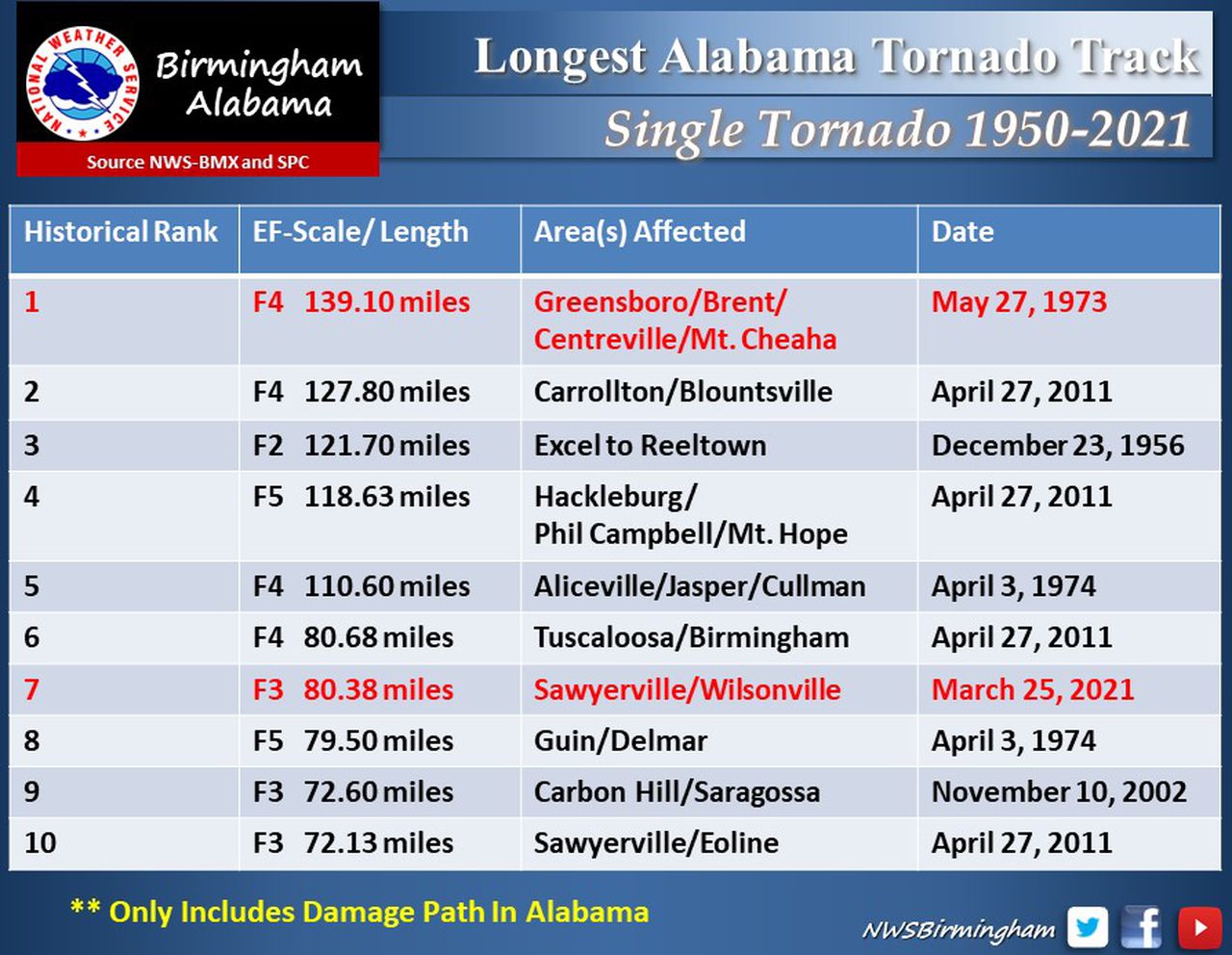
Here are the longest tornado tracks on record in Alabama.
KINGSTON-LAKE MARTIN TORNADO
Here’s a look at the track of Thursday’s deadly tornado from the preliminary storm report from the National Weather Service in Birmingham:
The tornado touched down at 12:48 p.m. Jan. 12 just east of U.S. Highway 82 and rolled a manufactured home along Autauga County Road 40.
The tornado rapidly strengthened as it approached the Old Kingston community and reached EF-3 intensity.
At least three manufactured homes were “obliterated,” the weather service said, with their frames thrown up to 100 yards along County Road 43.
A pickup truck was thrown 120 yards to the northeast, and a shallow crater was formed where it landed.
The tornado hit several homes along Sandy Ridge Road, where some of the deaths occurred.
The frame of a manufactured home was thrown 250 yards and into a field. Just downstream, several manufactured homes in a cluster were “shredded and thrown considerable distances,” the weather service said. Tree trunks were snapped relatively close to the ground, and the bark was ripped from them.
In total, five fatalities occurred along Sandy Ridge Road at three separate homes, the weather service said.
More damage continued to the northeast along County Road 140, where two people were killed in separate homes at the eastern end of the road.
At least five manufactured homes were “blown away with their frames thrown considerable distances,” the weather service said. Several vehicles were picked up and thrown, and one pickup truck had its cab separated from the bed.
The tornado continued northeast to County Road 42, causing massive tree damage along Autauga Creek.
The weather service said the most severe damage was observed from County Road 43 to County Road 42, and wind speeds were estimated to have reached at least 150 mph.
And they could have been even stronger.
“Based on the damage scene and contextual evidence, it is plausible that winds were stronger,” the weather service said. “However, with only manufactured homes in the path, there appear to be no damage indicators that will allow a higher rating.”
The tornado weakened slightly as it moved across County Road 57 but still damaged several homes.
It then crossed Interstate 65 and reached the Pine Level community, where several homes had roof damage and a manufactured home was rolled off its foundation and onto County Road 68 East.
The tornado crossed through the Pine Flat community, damaging more homes, and a manufactured home was rolled and destroyed.
The weather service said that the damage intensified as the tornado neared the Autauga-Elmore county line, where several site-built homes lost most of their roofs along County Road 68 East near Poplar Springs Road.
Similar damage was seen in northwest Elmore County as the tornado neared the Coosa River. The tornado crossed the river near Neely Road on the west bank and Kelly Road on the east bank.
The weather service said “countless” trees were snapped and uprooted as the tornado moved northeast toward the Elmore-Coosa county line at U.S. Highway 231.
The weather service said that radar showed a debris ball in southern Coosa County which matched ground observation of a wide area of snapped pine trees on either side of McKissick Road between the communities of Speed and Equality.
“The volume of snapped trees was enough to assign an EF-3 rating for this segment of the tornado’s path,” the weather service said.
More EF-3 damage occurred along County Road 18, where the weather service said vehicles were moved or flipped, numerous trees were snapped, one site-built home was destroyed and others heavily damaged.
The tornado continued northeastward into Tallapoosa County, where EF-1-caliber damage was observed. The tornado crossed Highway 63 South and neared the Wind Creek State Park area.
The tornado then moved toward Coven Abbett Road and then Elbert Road, damaging several homes and destroying several boat houses.
The tornado then crossed the northern section of Lake Martin, damaging additional lakefront homes. The weather service said numerous homes were damaged — some significantly — on River Run Road and the adjacent side streets. At least two homes were shifted from their foundation.
The weather service noted that the damage here, rated high-end EF-2, “could be partly due to the interaction of the tornado with the lake surface, as well as the exposed nature of these homes.”
The tornado continued northeast, causing sporadic EF-1 timber damage as it crossed U.S. Highway 280. The tornado then moved across the rest of Tallapoosa County causing EF-0 to EF-1 tree damage, including in the Sessions area.
The weather service said the tornado continued northeast into Chambers County, causing EF-0 to EF-1 damage.
The tornado weakened more as it neared Highway 77 and dissipated shortly after crossing County Road 114.