What changes in Birmingham, Montgomery under Alabamaâs new congressional map?
The new plan for Alabama’s congressional districts went before a three-judge federal court in Birmingham on Monday, as the court determines whether it fixes a likely violation of the Voting Rights Act.
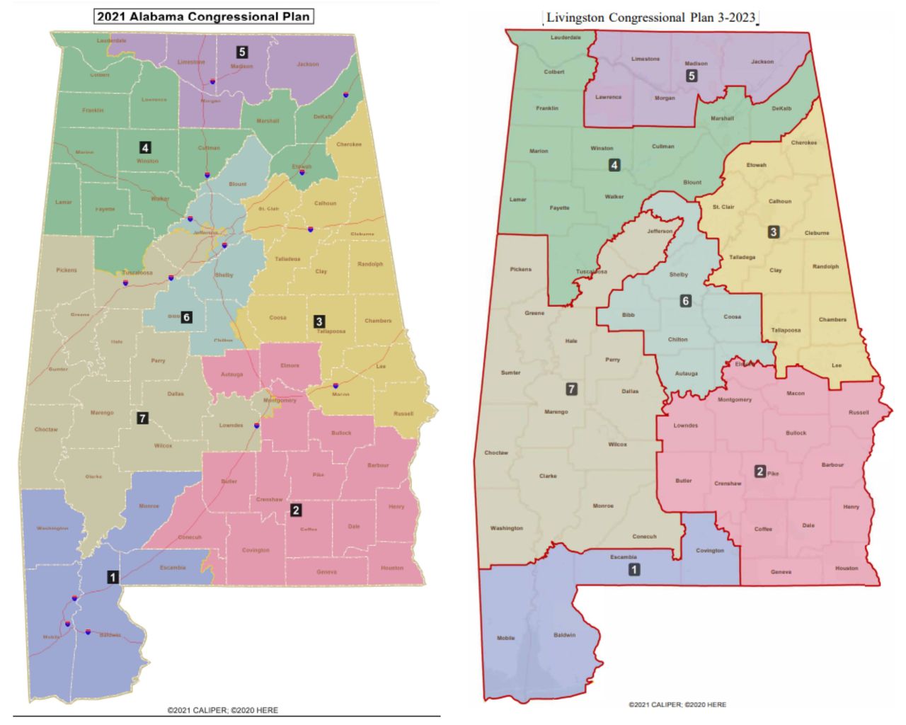
The new map, approved by the state legislature in July, includes some significant changes, especially in the Birmingham and Montgomery areas. Those areas are home to some of the largest Black population centers in Alabama, and are key to determining whether Alabama will have one or two majority-Black districts.
Changes in Birmingham
The Birmingham-Hoover Metro area is by far the most populous region in the state, and four of the state’s seven districts touch the area.
Under Alabama’s current map, which the Supreme Court ruled earlier this year likely violates the Voting Rights Act, the region is primarily split between Districts 6 and 7. That’s largely a split between Rep. Terri Sewell, D-Birmingham, and Rep. Gary Palmer, R-Hoover.
District 7 is currently Alabama’s only majority-Black district, and would remain that way under the new plan. District 2, in southeast Alabama and represented by Rep. Barry Moore, R-Enterprise, would become 40% Black and 45% Democratic under the new plan, making it the second-most competitive district in the state. That’s according to data from Dave’s Redistricting.
While there are lots of small changes all over the state, the map makes a few changes in the Birmingham area that are particularly interesting. The new map would expand Sewell’s district further north into Jefferson County, picking up places like Fultondale and Tarrant. Palmer’s new district would instead stretch further south of Birmingham, reaching all the way to Prattville and the Montgomery suburbs.
One major suburb in Homewood would shift to Palmer’s district, while the affluent Birmingham neighborhoods of Forest Park and Highland Park would move into Sewell’s district.
Meanwhile, some majority-Black, east-Birmingham neighborhoods like East Lake and Gate City move to Palmer’s District 6.
The map below shows Alabama’s current congressional districts in different colors, with the new proposed districts overlaid in black.
[Click here to explore the map further.]
Changes in Montgomery
The Montgomery area also sees some big changes, and the biggest would be that the city would no longer be split in two between representatives.
The current map cuts the city cleanly in half, and sees the four-county metro area split between Districts 7 and 2, between Sewell and Moore.
The new map would move all of Autauga County – the fastest-growing county in the Montgomery Metro area – into Palmer’s District 6. But Montgomery city and all of Lowndes County, a neighboring majority Black county, would shift into Moore’s district.
That means Montgomery city would no longer be represented in part by Sewell, and instead would be in District 2. District 2 would be more competitive, but still predominantly white. Under the new map, District 2 would move from 62% white to 52% white, and from 30% Black up to 40% Black.
[Click here to explore the map further.]
There are many other changes in rural Alabama and otherwise, including whole counties changing districts. Lawrence, Etowah, Blount, Lowndes, Macon, Russell, Washington, Monroe and Conecuh counties all swap districts under the newest plan.
The current plan could be overturned by the court, since it doesn’t have two majority-Black districts. The plaintiffs in the case have put forth nearly a dozen alternative maps that show how a two-majority-Black-district map could be possible. You can see those proposals here.
Do you have an idea for a data story about Alabama? Or questions about Alabama that data may be able to answer? Email Ramsey Archibald at [email protected], and follow him on Twitter @RamseyArchibald. Read more Alabama data stories here.