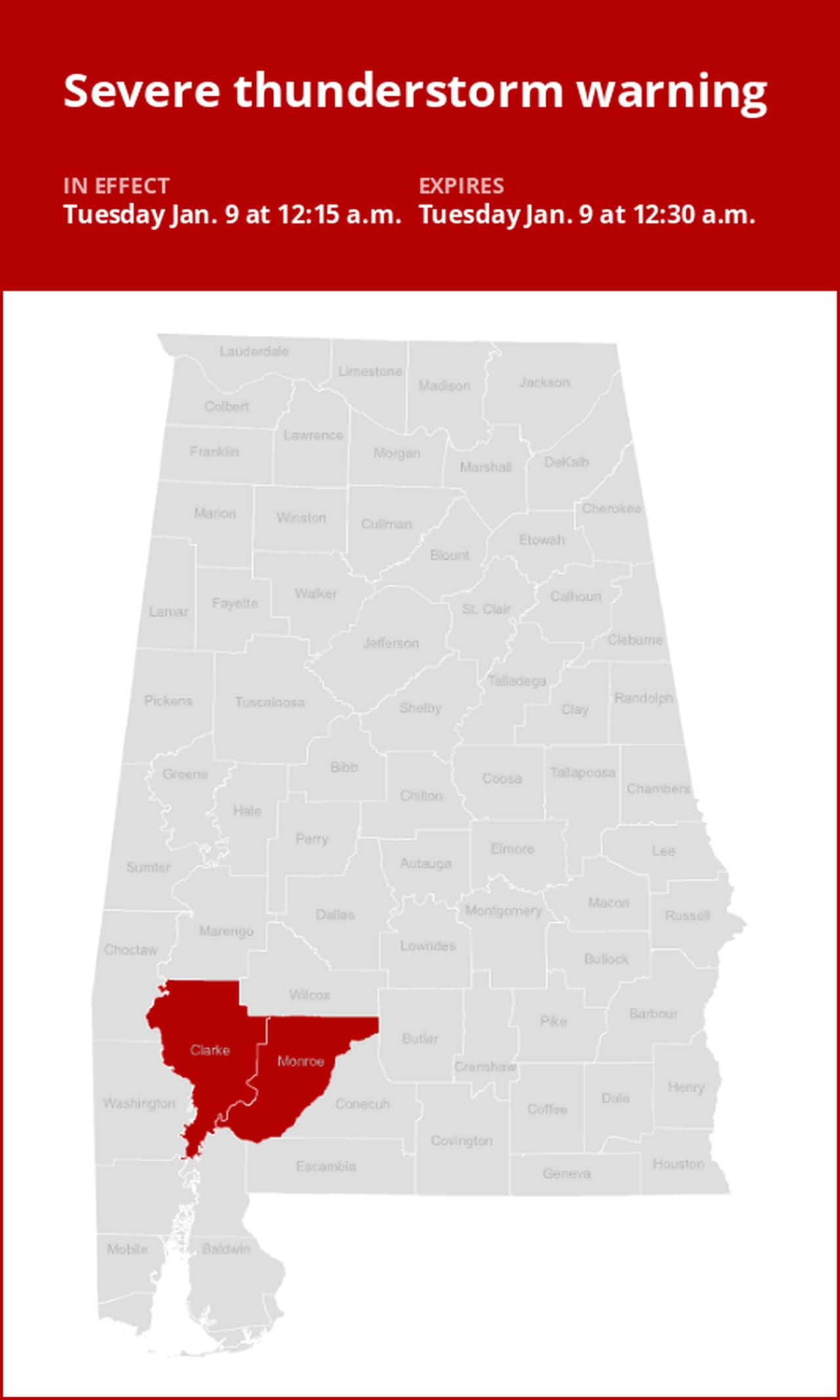
Update: Thunderstorms with damaging winds to hit Clarke and Monroe counties Tuesday
On Tuesday at 12:15 a.m. an updated severe thunderstorm warning was issued by the National Weather Service in effect until 12:30 a.m. for Clarke and Monroe counties.
Residents should be prepared for wind gusts of up to 70 mph.
“At 12:14 a.m., severe thunderstorms were located along a line extending from 5 miles south of Whatley to 10 miles east of Jackson to 14 miles west of Uriah, moving northeast at 60 mph,” according to the weather service. “Expect considerable tree damage. Damage is likely to mobile homes, roofs, and outbuildings.”
The warning is for Whatley.
The weather service comments, “A Tornado Watch remains in effect until 7 a.m. for south central and southwestern Alabama. A tornado watch remains in effect for the warned area. Tornadoes can develop quickly from severe thunderstorms. Although a tornado is not immediately likely, if one is spotted act quickly and move to a place of safety inside a sturdy structure, such as a basement or small interior room. For your protection move to an interior room on the lowest floor of a building.”
Shielding yourself from approaching lightning: Expert safety guidelines
Lightning strikes the United States approximately 25 million times each year, with the bulk of these electrical discharges occurring during the summer months. Tragically, lightning claims the lives of about 20 individuals annually, as reported by the weather service. The risk of lightning-related incidents escalates as thunderstorms draw near, reaching its peak when the storm directly looms overhead. However, it gradually recedes as the tempest moves away.
To guarantee your safety in the midst of a thunderstorm, take into account the following recommendations:
1. Lightning safety plan:
- When venturing outdoors, it’s crucial to have a lightning safety plan in place.
- Stay vigilant by monitoring the sky for ominous signs and listening for the telltale sound of thunder. If thunder is audible, it’s a clear indication of nearby lightning.
- Seek a safe place to shelter, preferably indoors.
2. Indoors safety measures:
- Once you’ve found shelter indoors, abstain from using corded phones, electrical appliances, or plumbing fixtures, and refrain from approaching windows and doors.
- These precautions help reduce the risk of electrical surges, as lightning can follow conductive pathways.
3. Wait for the all-clear:
- After the last lightning strike or thunderclap, wait at least 30 minutes before resuming outdoor activities.
- Lightning can strike even when a storm has seemingly passed, so exercise caution.
When indoor shelter isn’t available:
If you find yourself outdoors with no access to indoor shelter during a thunderstorm, take these steps to maximize your safety:
- Avoid open fields, hilltops, or ridge crests, which expose you to greater lightning risk.
- Steer clear of tall, isolated trees and other prominent objects. In wooded areas, stay close to lower stands of trees.
- If you’re in a group, ensure that individuals are spaced out to prevent lightning current from transferring between people.
- Camping in an open setting during a thunderstorm is strongly discouraged. If you have no alternative, set up camp in a valley, ravine, or other low-lying areas. It’s crucial to note that a tent provides no protection against lightning.
- Do not approach water bodies, wet objects, or metal items. While water and metal don’t attract lightning, they conduct electricity effectively and can pose significant risks.
In summary, when facing the threat of lightning, preparedness and vigilance are your best allies. By following these guidelines, you can significantly reduce the likelihood of lightning-related incidents and prioritize your safety.
Mastering wet roads: Safety tips for heavy rainfall
When heavy rain pours, the risk of flooding and treacherous roads rises. Here’s your guide from the weather service to staying safe during downpours:
Beware of rapid water flow:
- In heavy rain, refrain from parking or walking near culverts or drainage ditches, where swift-moving water can pose a grave danger.
Maintain safe driving distances:
- Use the two-second rule to maintain a safe distance from the car in front of you and allow an extra two seconds in heavy rain.
Slow down and stay cautious:
- On wet roads, reducing your speed is crucial. Ease off the gas pedal gradually and avoid abrupt braking to prevent skidding.
Choose your lane wisely:
- Stick to the middle lanes to minimize the risk of hydroplaning. Outer lanes are more prone to accumulating water.
Prioritize visibility
- Enhance your visibility in heavy rain by turning on your headlights. Watch out for vehicles in blind spots, as rain-smeared windows can obscure them.
Watch out for slippery roads:
- The first half-hour of rain is when roads are slickest due to a mix of rain, grime, and oil. Exercise heightened caution during this period.
Keep a safe distance from large vehicles:
- Don’t follow large trucks or buses too closely. The spray created by their large tires reduces your vision. Take care when passing them as well; if you must pass, do so quickly and safely.
Mind your windshield wipers:
- Overloaded wiper blades can hinder visibility. If rain severely limits your sight, pull over and wait for conditions to improve. Seek refuge at rest areas or protected spots.
- When stopping by the roadside is your only option, position your vehicle as far off the road as possible, ideally beyond guardrails. Keep your headlights on and activate emergency flashers to alert other drivers of your position.
By following these safety measures, you can significantly reduce risks and ensure your well-being when heavy rain pours down. Stay informed about weather conditions and heed advice from local authorities to make your journey safe and sound.
Advance Local Weather Alerts is a service provided by United Robots, which uses machine learning to compile the latest data from the National Weather Service.