Tropical Storm Idalia moves away from US
The National Hurricane Center was tracking two tropical storms and a hurricane in the tropical Atlantic Ocean on Thursday.
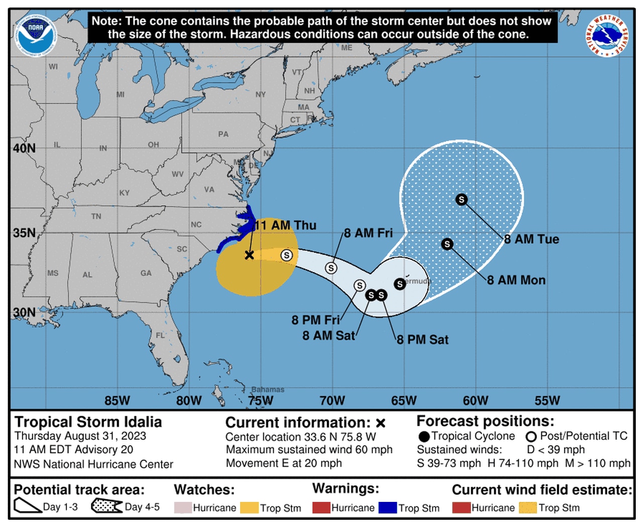
One of those storms is the former Hurricane Idalia, which made landfall on Florida’s Gulf Coast on Wednesday as a Category 3 hurricane. Idalia on Thursday morning was a tropical storm and had moved off the coast of North Carolina and into the western Atlantic.
As of 10 a.m. CDT Thursday, Tropical Storm Idalia was located about 85 miles southeast of Cape Lookout, N.C., and was on a path eastward at 20 mph.
Tropical Storm Idalia could move near Bermuda in a few days.
Idalia had sustained winds of 60 mph on Thursday morning. Idalia peaked in strength early Wednesday morning and was briefly a Category 4 hurricane with 130 mph winds, but it weakened slightly just before coming onshore near Keaton Beach, Fla., as a Category 3 with 125 mph winds.
Forecasters said little change in strength is expected today. Some slight weakening could begin tonight and on Friday.
The hurricane center said Idalia continued to cause life-threatening flash flooding in parts of eastern North Carolina on Thursday.
Tropical storm warnings continued for areas along the coast.
Forecasters said Idalia could bring an additional 2 to 4 inches of rain to parts of coastal North Carolina through this afternoon.
The hurricane center added that a few tornadoes will also be possible this morning in eastern North Carolina.
Idalia is expected to stay on an eastward path, which would take it away from the United States. Idalia could become a concern for Bermuda, however. The latest forecast track from the hurricane center shows the center of the storm — which is forecast to be a tropical storm — could move very near the island by early next week.
Bermuda just had a brush with Hurricane Franklin, which tracked to the northwest of the island but brought a lot of wind and rain to the area on Wednesday.
Speaking of Franklin …
HURRICANE FRANKLIN
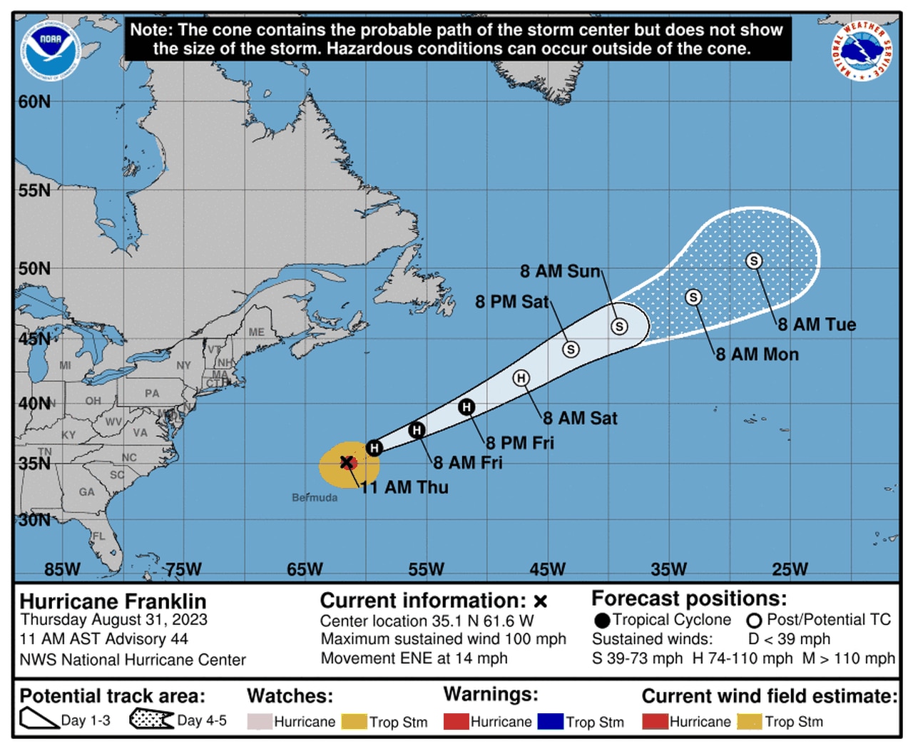
Hurricane Franklin is expected to head out to sea.
Franklin was still a hurricane on Thursday morning as it headed north and eastward and away from Bermuda.
As of 10 a.m. CDT Thursday, Hurricane Franklin was located about 265 miles northeast of Bermuda and was moving east-northeast at 14 mph.
Franklin had 100 mph winds, making it a Category 2 hurricane. Franklin’s peak was as a top-end Category 4 hurricane with 150 mph winds earlier this week. That makes Franklin the strongest hurricane of the season to this point.
Franklin has been a hurricane since Aug. 26.
TROPICAL STORM JOSE
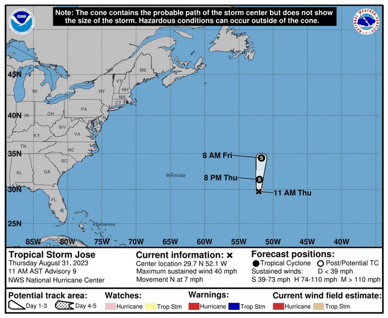
Tropical Storm Jose won’t be around much longer.
If that wasn’t enough the hurricane center was also tracking newly named Tropical Storm Jose in the central Atlantic. Jose isn’t expected to strengthen much and won’t last all that long.
It’s no threat to the U.S. — or any land areas.
As of 10 a.m. CDT Thursday, Tropical Storm Jose was located 770 miles east of Bermuda and was moving north at 7 mph. Jose had winds of 40 mph, making it a minimal tropical storm.
The hurricane center said little change in strength is forecast over the next day or so, and Jose could be absorbed by Franklin by the weekend.
ELSEWHERE IN THE ATLANTIC
The hurricane center was also monitoring two tropical waves in the Atlantic.
One was located west of the Cabo Verde Islands on Thursday and could become a tropical depression over the next few days. It’s expected to track to the west-northwest to northwest over the next few days but is far from the U.S.
The second disturbance was in the central tropical Atlantic and is what’s left of former Tropical Storm Gert. It was located several hundred miles north-northeast of the Leeward Islands and has a low probability of development.
There were no areas to watch in the Gulf of Mexico as of Thursday.