Tropical depression expected to form soon in Atlantic
A tropical depression could form today in the Atlantic Ocean. And there’s another potential storm right on its heels.
This is very unusual for this point in the season, especially in an El Nino year.
The National Hurricane Center on Monday continued to track a tropical disturbance in the central Atlantic that was very close to becoming a depression.
Forecasters said it continued to organize overnight, and if those trends continue it could be upgraded later today to Tropical Depression Three.
The system is expected to continue to track westward at 15 to 20 mph and could strengthen through midweek.
A system has to have a defined center of circulation and winds of at least 39 mph to become a tropical storm and get a name. The next name on the 2023 storm list is Bret.
The potential Bret could head in the direction of the Lesser Antilles through this week, but it’s too soon to say if it could affect the mainland U.S. Puerto Rico will be watching it closely, however.
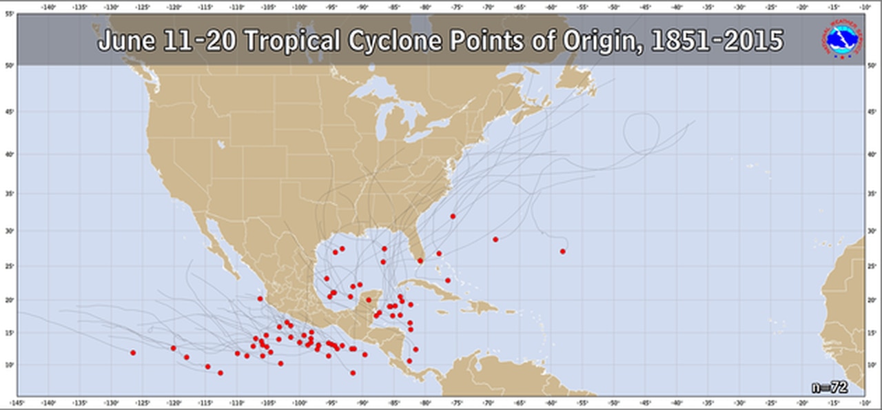
A storm developing this far east in the Atlantic is very unusual for mid-June. Here’s a look at where storms have formed in the Atlantic in mid-June:
Here’s where tropical systems have developed in the past in the June 11-20 timeframe.
But that isn’t the only thing cooking in the Atlantic. The hurricane center was tracking a second disturbance in that same region on Monday.
That disturbance was located several hundred miles south-southwest of the Cabo Verde Islands off the west coast of Africa.
It also has a good shot to develop more, and the hurricane center said another tropical depression could form in the next few days as the disturbance tracks to the west at 10 to 15 mph.
That system has a 40 percent chance of becoming a depression or storm in the next week.
The Atlantic hurricane season began June 1 and lasts until Nov. 30.
Activity this year is expected to be near average as far as the number of storms goes.
El Nino is also active, which typically helps suppress the number of Atlantic tropical storms. However, El Nino is being countered by extremely warm water in parts of the Atlantic and a more active parade of storms expected to emerge off the west coast of Africa.
Forecasters are watching carefully to see how this warmer water and active storm track affects the rest of the season.