Stormy pattern for Alabama through Wednesday
Rain and storms will be in the forecast for parts of Alabama on and off through Wednesday, and some of those storms could be severe.
There will be a Level 1 out of 5 threat for severe weather along the Gulf Coast — including the Mobile area — today. Then the southern half of Alabama will also face another round of severe weather on Tuesday, possibly Tuesday afternoon into early Wednesday morning.
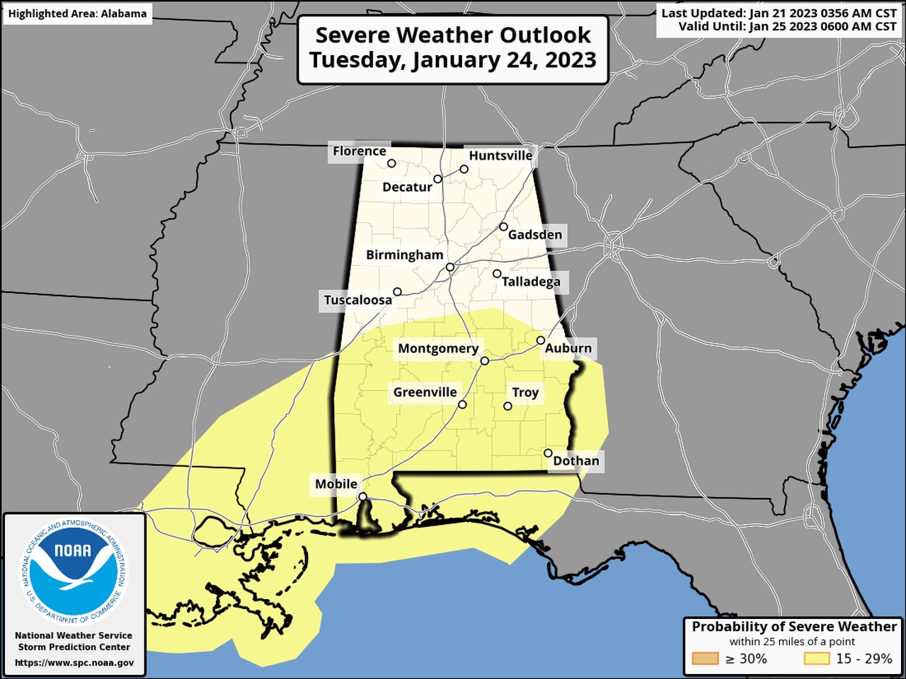
Here is Tuesday’s severe weather outlook:
Severe weather will be possible across the southern half of Alabama on Tuesday night into Wednesday morning.
Damaging winds, tornadoes and heavy rain will all be possible on both days, according to the National Weather Service.
NOAA’s Storm Prediction Center has a Level 1 out of 5 risk (or marginal risk) in place along the Gulf Coast today.
A Level 1 risk means that isolated severe storms will be possible. Rain and storms were moving across south Alabama on Saturday morning and were expected to spread northward during the day but were expected to stay under severe limits.
Forecasters at the National Weather Service in Mobile, however, will also be watching to see if a warm front over the Gulf will push northward and reach the coast. Areas south of that warm front — if it makes it that far north — would have a better potential to see strong to severe storms, including a tornado or two.
If that were to happen, the weather service said, it wouldn’t be until later tonight.
Rain showers could linger into Sunday, forecasters said, but drier weather is expected to take hold on Monday.
The next storm system will begin to affect Alabama on Tuesday — and it has the potential to bring severe weather to more of Alabama.
The Storm Prediction Center’s Day 4 severe weather outlook continues to outline a severe weather risk for the southern half of Alabama.
The timeframe for severe weather on Tuesday appears to be later in the day, from Tuesday night into Wednesday morning.
Tornadoes and damaging winds again look to be possible on Tuesday, forecasters said.
The weather service is also cautioning about the potential for strong gradient winds with the Tuesday system. Winds even away from storms could gust as high as tropical-storm force (40 mph) as the system moves through the state.
A cold front is expected to bring an end to the rain and storm chances on Wednesday, and drier weather is expected to end the work week.
