South Alabama faces enhanced severe weather risk tonight: What to know
The National Weather Service is warning there is the potential for a high-impact severe weather event on the horizon for south Alabama starting late tonight.
Tornadoes, including a few strong ones (EF-2+), wind gusts of 70 mph and 2 to 6 inches of rain will be possible starting Monday night and into Tuesday with two rounds of storms.
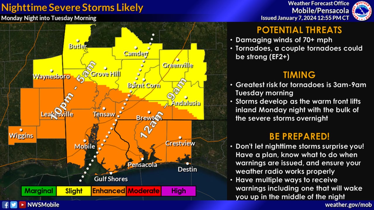
This looks to be an overnight event for most. Rain and storms will be possible starting later this afternoon, but the core of the severe weather threat will arrive late Monday night (10 p.m.) and into the early-morning hours of Tuesday.
That makes it especially important for Alabamians to have not one but multiple ways of getting severe weather warnings overnight.
“This has the potential to be a rather intense severe event occurring overnight,” the weather service in Mobile said in its Monday morning forecast discussion. “Be sure to continue to stay updated and have multiple ways to receive warnings that are battery operated and charged as power may go out well before severe thunderstorms arrive.”
Here’s a look at timing from the National Weather Service:
SOUTHWEST ALABAMA:
Severe weather will be possible in southwest Alabama starting around 10 p.m. in the west and pushing eastward overnight.NWS
SOUTHEAST ALABAMA:
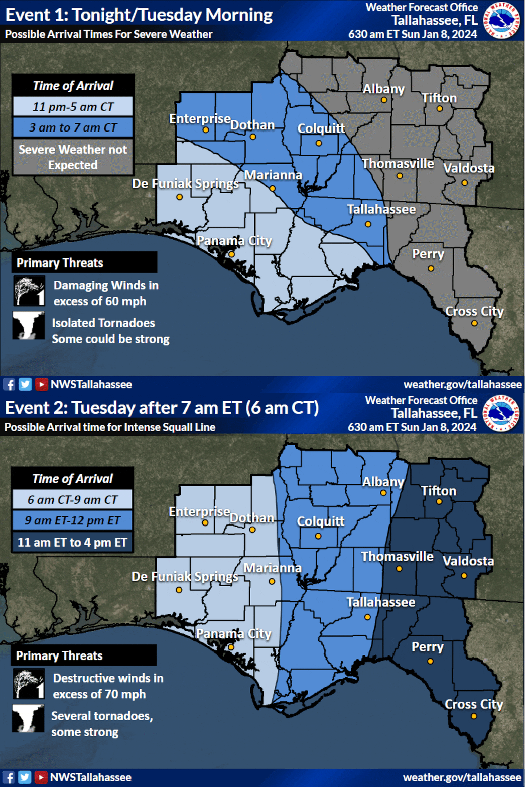
Storms will reach southeast Alabama in the early hours of Tuesday.NWS
CENTRAL ALABAMA:
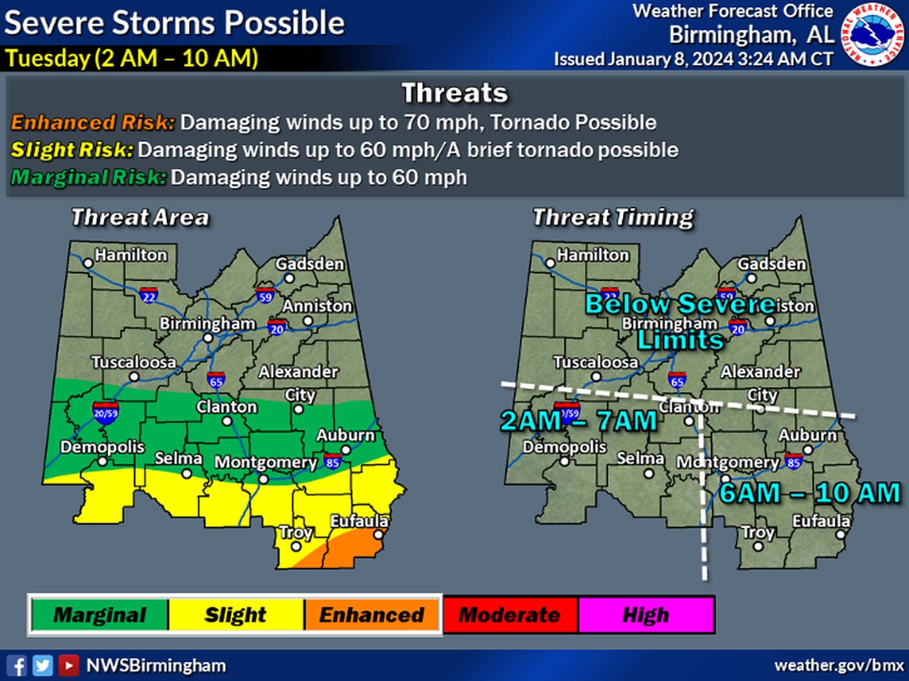
No severe weather is expected for north-central Alabama, but the southern half could have to deal with some overnight.NWS
South and south-central Alabama will be the places to watch for severe weather. No severe weather is expected in north and north-central Alabama, according to forecasters, but downed trees and power lines will also be possible there as well as heavy rain.
Strong winds will affect the entire state — even those areas not expecting severe weather.
The weather service has placed the entire state under wind advisories that will go into effect later this afternoon. Non-thunderstorm winds will be sustained in the 20-30 mph range across the state, and gusts could reach 50 mph or so through Tuesday.
Winds that strong will be capable of downing tree limbs and knocking out power across the state from Monday afternoon into the day on Tuesday.
Winds along the immediate coast could be even higher, and a high wind warning will be in effect there.
NOAA’s Storm Prediction Center has a Level 3 out of 5 risk for severe weather for parts of south Alabama today. The rest of south Alabama has a Level 2 risk, and a Level 1 risk extends as far north as Tuscaloosa, Clanton and just south of Auburn.
A Level 3 (enhanced) risk means that numerous severe storms will be possible. Scattered severe weather is possible in the Level 2 areas and isolated severe storms are possible in the Level 1 areas.
In addition to the threat from storms, those along the coast will have a high risk of rip currents, 10-foot waves off the coast, coastal flooding and gale warnings over the Gulf.
The severe threat will carry over into the morning on Tuesday, and the SPC is maintaining a Level 3 risk for southeast Alabama on Tuesday:
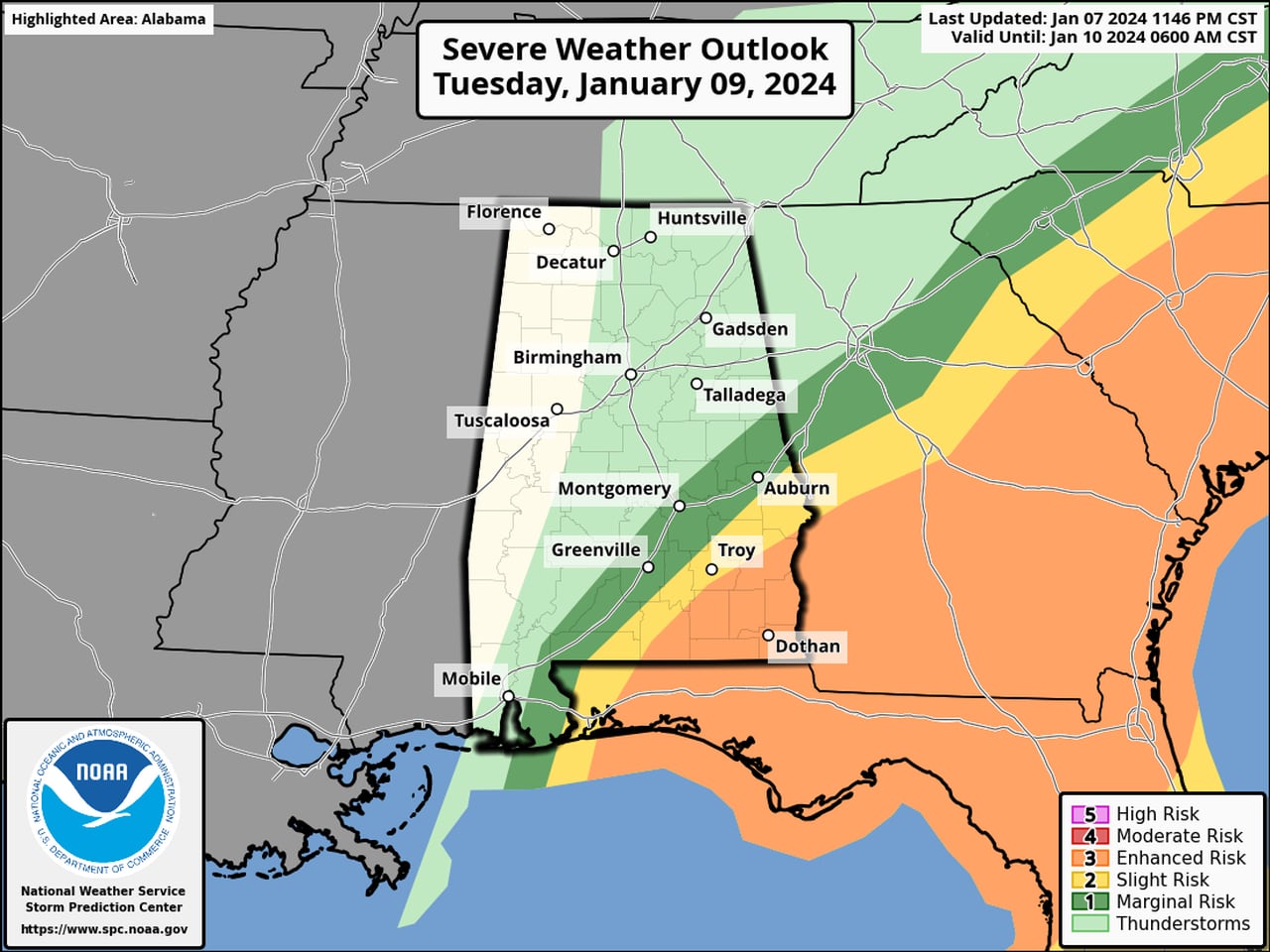
A Level 3 threat for severe weather will extend into Tuesday morning for southeast Alabama.SPC
TWO ROUNDS OF STORMS EXPECTED FOR SOUTH ALABAMA
The weather service is still expecting two rounds of storms starting later tonight — anywhere from 10 p.m. until midnight. The first could develop along and ahead of a warm front that will lift northward from the Gulf. Areas along and south of the warm front could see supercell storms capable of producing strong (EF-2+) tornadoes and strong winds.
That will be followed by what could be an extremely strong squall line of storms that will push from west to east across the state. Forecasters have the most confidence of this line of storms producing severe weather.
The portion of the line in north and north-central Alabama is expected to stay below severe limits. The portion in south Alabama could produce widespread wind damage and tornadoes, again including a few strong ones.
In addition storms could bring as much as 2-6 inches of rain to parts of south Alabama, and parts of north and central Alabama could get 2-4 inches.
Here’s the rainfall outlook:
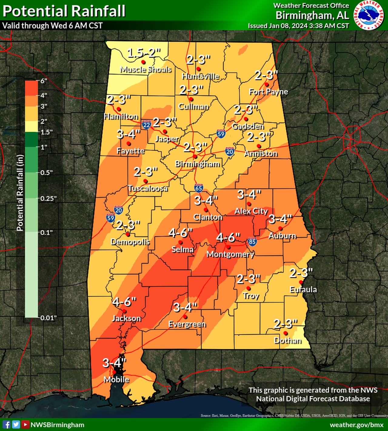
Here are projected rain totals through Wednesday for Alabama.NWS
MORE SEVERE WEATHER FRIDAY?
Rain and storms are expected to exit Alabama during the day on Tuesday (although it will still be windy), and calmer weather is expected for the middle of the week.
However, the Storm Prediction Center has added the potential for severe weather for Alabama again on Friday as the next weather system approaches the state.
Here’s the outlook for Friday:
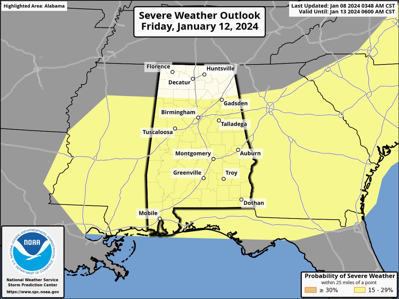
Here’s where there could be more severe weather on Friday.SPC
