Severe weather update: Tornado watch issued
The National Weather Service on Monday night was gearing up for what could be a long night of stormy weather for south Alabama, and a tornado watch has been put in place for that part of the state.
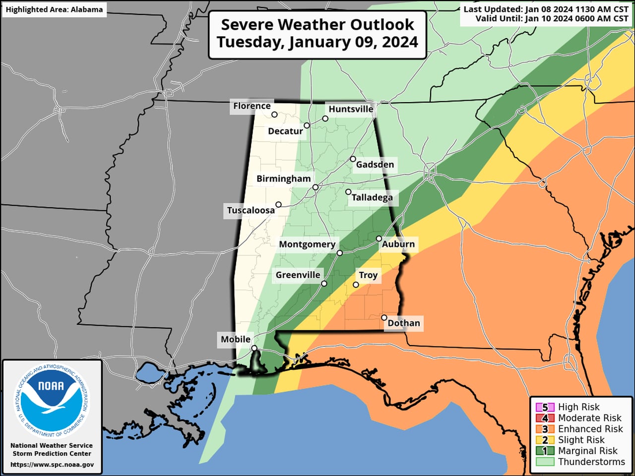
NOAA’s Storm Prediction Center has expanded eastward a Level 3 out of 5 risk for severe weather for Alabama overnight. The Level 3 risk area now includes not only southwest Alabama but more of south-central Alabama as well.
A Level 3 risk means that numerous severe storms will be possible. Tornadoes, including a few strong (EF-2+) ones, wind gusts as high as 70 mph and up to 6 inches of rain will be possible in those areas overnight and into Tuesday morning.
Most of the rest of south Alabama has a Level 2 severe weather risk and could see scattered severe storms. A Level 1 risk extends farther north to include parts of central Alabama as well. Those areas could see isolated severe storms.
North and north-central Alabama are not expected to have to deal with severe storms overnight, but thunderstorms will be possible as well as heavy rain (2-4 inches) and very strong winds.
In fact, the entire state is now under a wind advisory. Winds could gust as high as 50 mph overnight — even in areas not expecting severe weather. Winds that strong could bring down tree limbs and power lines.
A tornado watch will be in effect for south Alabama until 7 a.m. Tuesday:
The Storm Prediction Center said several tornadoes will be “likely” in the watch area, “with a couple intense tornadoes possible.” The watch area also includes parts of Louisiana, Mississippi and the Florida Panhandle.
Forecasters also said scattered damaging winds will be likely with isolated gusts up to 75 mph possible as well as large hail.
The SPC said: “A squall line is expected to strengthen while moving eastward overnight from Louisiana/southern Mississippi to southern Alabama and the western Florida Panhandle closer to sunrise. The storm environment will be favorable for rotating storms within and just ahead of the line, with the potential for a couple of strong (EF2-EF3) tornadoes, damaging gusts up to 75 mph and isolated large hail up to 1.5 inches in diameter.”
The Alabama counties in the tornado watch are: Baldwin, Butler, Choctaw, Clarke, Coffee, Conecuh, Covington, Crenshaw, Dale, Escambia, Geneva, Henry, Houston, Mobile, Monroe, Washington and Wilcox.
WINDS RAMPING UP
As of 9 p.m. Monday it’s been on the quiet side across the state as far as severe weather goes. Rain was falling over a wide area, and non-thunderstorm winds were increasing as expected.
But the winds were picking up. So far the weather service in Huntsville has received reports of downed trees and power lines in parts of Jackson and DeKalb counties in northeast Alabama. Jefferson County has had a reported downed tree as well as of 8 p.m.
The weather service was also watching storms developing over the Gulf and a line of storms taking shape to the west of Alabama in southern Mississippi and Louisiana.
The storms over the Gulf are expected to move northward tonight into south Alabama. That is expected to be Round 1 of the potential severe weather. Then what could be a powerful squall line could approach the state from the west early Tuesday morning. That’s Round 2.
The threat for severe weather will continue later Tuesday in southeast Alabama, where there will continue to be a Level 3 risk for severe weather. Here’s the outlook for Tuesday (from 6 a.m. onward):
The threat for severe storms will continue through the morning hours in southeast Alabama.SPC
Here’s what the NWS in Mobile was thinking on Monday evening: