Severe weather risk ticks upward for Alabama on Tuesday
Severe storms will be possible in Alabama on Tuesday ahead of a cold front.
Tornadoes, damaging winds and hail will be possible with Tuesday’s storms, which could arrive in the form of a squall line ahead of a cold front, according to the National Weather Service. There could also be some supercell storms that develop ahead of or along the line.
“Since it’s been a while since we’ve had a tornado threat, now is the time to dust off/test your weather radios and severe weather plans,” the weather service said in its forecast discussion on Monday morning.
The time frame appears to be Tuesday afternoon (as early as noon) in west Alabama, with storms tracking into eastern Alabama during the evening hours.
The tornado threat appears to be slightly higher in parts of western Alabama, but the weather service warned a quick-forming twister will be possible in all areas.
NOAA’s Storm Prediction Center has upgraded the severe weather risk for parts of Alabama, adding a Level 2 out of 5 risk for the western half of the state for Tuesday.
A Level 2 risk (or slight risk) means that scattered severe storms will be possible.
The rest of Alabama will have a Level 1 out of 5 risk for severe weather, which means that isolated severe storms will be possible. The Level 1 risk has been expanded eastward to include all of Alabama as of Monday.
In addition to the storms it could be windy in parts of north and central Alabama on Tuesday, and pressure gradient winds could gust as high as 35 mph after the storms move out, according to forecasters.
Those kind of gusts could send Halloween decorations flying, forecasters said.
The storms are expected to be gone by Wednesday, but there could be a few lingering clouds.
Cooler and drier weather is expected on Thursday and Friday (except possibly along the coast, which could see some rain on Friday), and the next weather system looks to make an appearance by Saturday.
So far the Storm Prediction Center has no mention of severe weather for Alabama on Saturday.
Here’s a look at the timing for Tuesday’s storms (as of Monday morning):
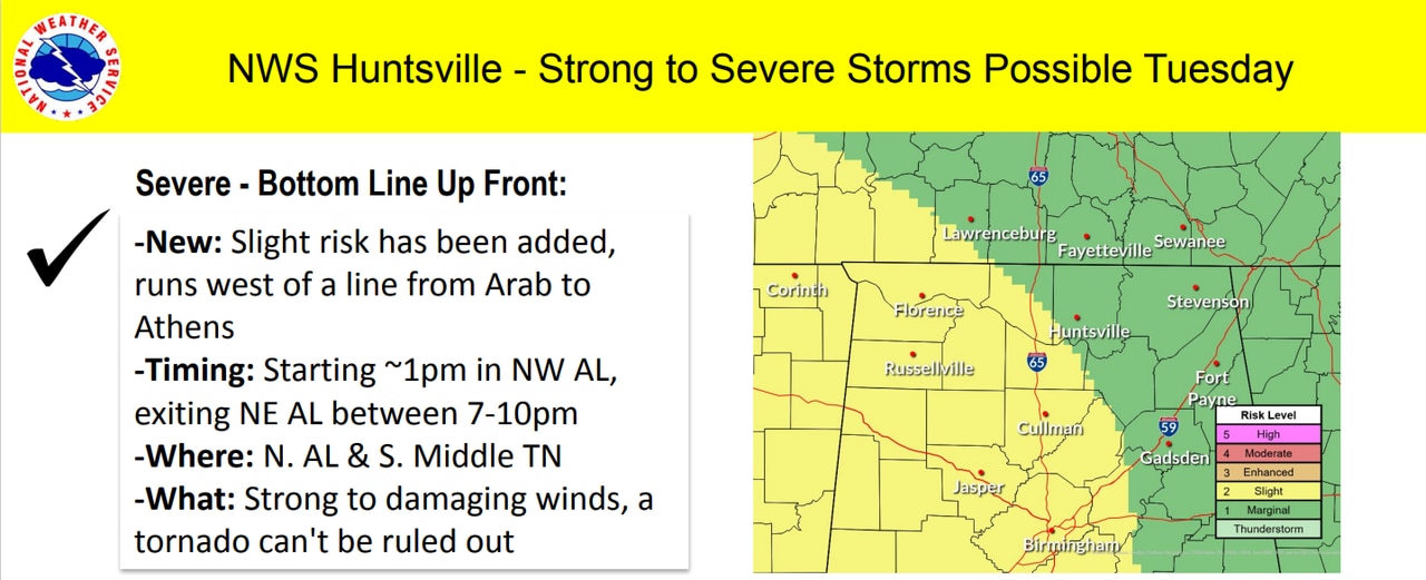
NORTH ALABAMA
Here’s what the National Weather Service in Huntsville was thinking about how storms will affect north Alabama on Tuesday.
Storms could reach northwest Alabama by 1 p.m. Tuesday and move out of the state by 10 p.m., according to the National Weather Service in Huntsville.
CENTRAL ALABAMA
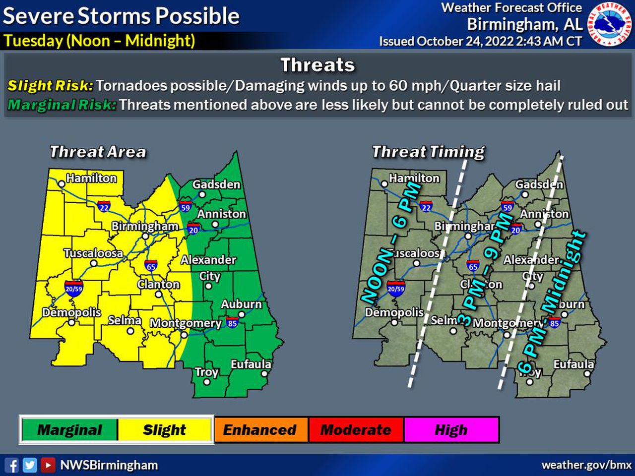
Severe storms could reach west-central Alabama as early as noon on Tuesday, according to forecasters.
The National Weather Service in Birmingham is thinking storms could enter west Alabama as early as noon on Tuesday and track eastward, exiting eastern Alabama as late as midnight.
SOUTH ALABAMA
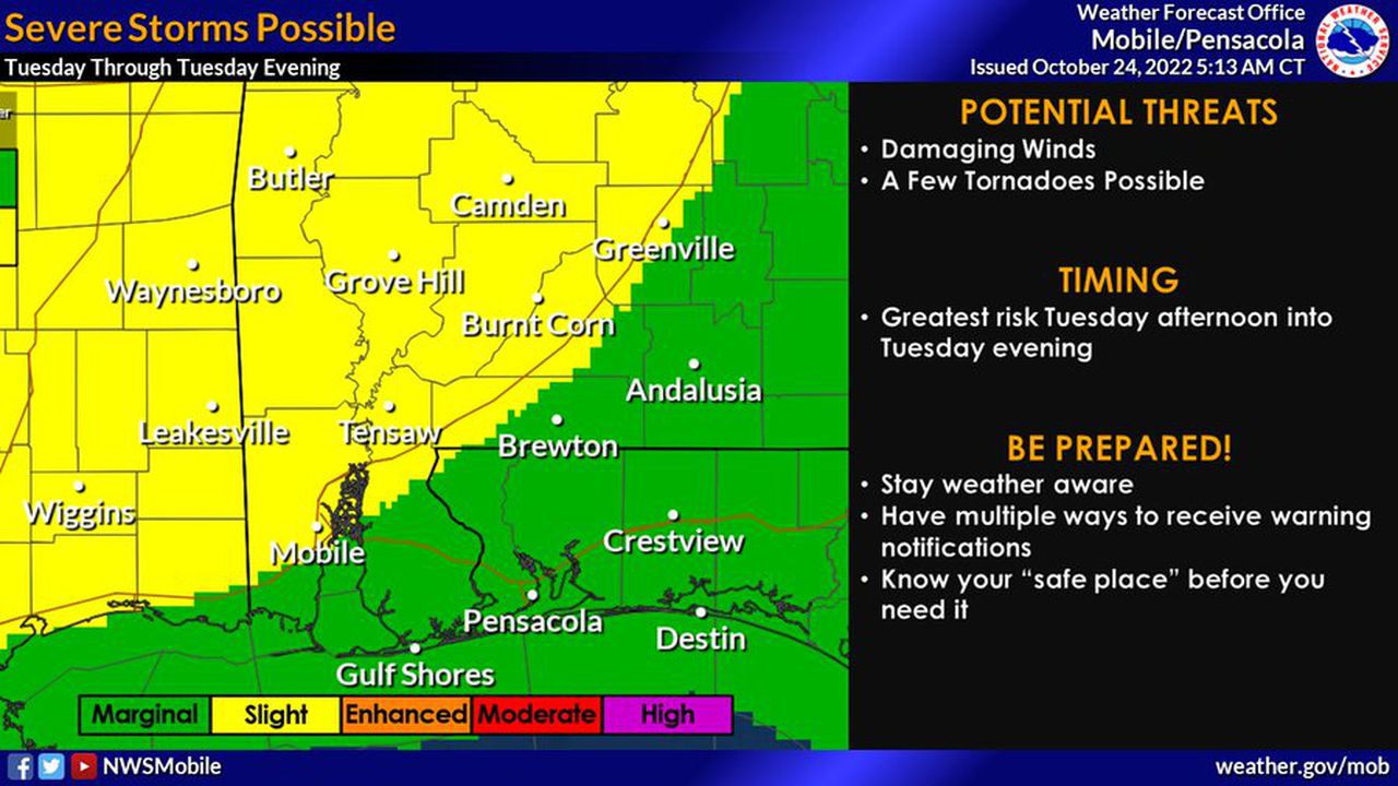
Forecasters will be watching for possible severe storms starting on Tuesday afternoon in southwest Alabama.
Strong to severe storms could enter southwest Alabama on Tuesday afternoon and head eastward across south Alabama into Tuesday night, according to the National Weather Service in Mobile.
Southeast Alabama will have to be on guard for storms later Tuesday afternoon into Tuesday night, according to the National Weather Service in Tallahassee, Fla.: