More storms possible tonight and Sunday in Alabama
Alabama is not done with severe weather just yet.
More strong to severe storms will be possible starting later Saturday night in Alabama, and multiple waves of storms will be possible through the day on Sunday along a slow-moving warm front.
South and south-central Alabama will be the places to watch for the upcoming waves of storms. North Alabama could see rain and even a storm or two, but widespread severe weather isn’t expected this time around.
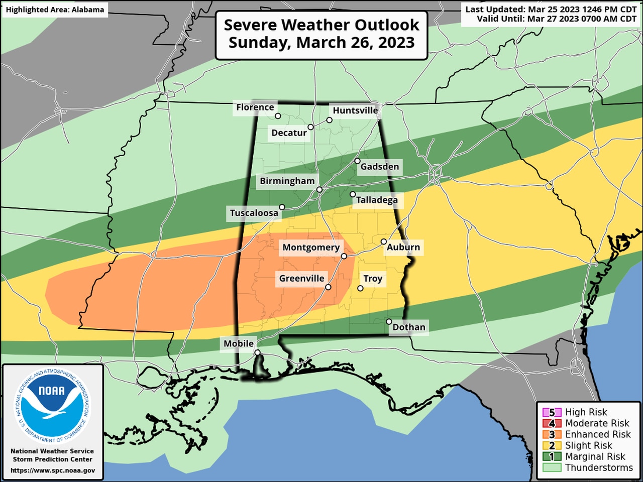
The severe weather risk for Sunday for part of Alabama has been raised to a Level 3 out of 5, mainly out of concern for large hail, according to the National Weather Service. There will be a Level 2 risk overnight for parts of the state (see that map at the top of this post).
Here is the severe weather outlook for Sunday:
There will be a Level 3 out of 5 risk for severe weather on Sunday in the areas in orange. A large part of the rest of the state could also see severe storms on Sunday.
Tonight’s storms could come less than one day after the last round of storms, which began Friday night in north Alabama and continued into Saturday in south Alabama. At least three tornadoes have been confirmed so far from those storms in north Alabama, and one person was killed in Morgan County.
South Alabama was also hit with several severe storms during Saturday afternoon.
Tonight’s storms could be big hail producers and could also bring damaging winds. There will also be the possibility of a tornado, though the probabilities of those are not as high tonight as they were last night.
South Alabama will have the higher probabilities for seeing severe storms tonight and Sunday. The threat for isolated severe storms can’t be ruled out farther north into central Alabama as well, according to the National Weather Service.
NOAA’s Storm Prediction Center has a Level 2 out of 5 risk for severe weather for part of south and south-central Alabama through the overnight hours tonight.
A Level 2 risk means that scattered severe storms will be possible.
More of south Alabama and part of central Alabama has a Level 1 risk, which means that isolated severe storms will be possible.
A Level 3, or enhanced risk, will be in place on Sunday for parts of south and south-central Alabama, which means that numerous severe storms will be possible.
The National Weather Service in Birmingham said the severe weather outlook over the next day is complex and could involve multiple rounds of storms in some places.
Forecasters as of Saturday think there could be two main waves of storms. The first could begin later tonight and last into Sunday morning. Then another round of storms could develop on Sunday afternoon and last into Sunday night.
There could also be storms that develop in between.
Areas that get multiple storms could also have to deal with flooding, the weather service said.
Here is a look at what the National Weather Service offices were expecting as of Saturday evening: