Level 2 severe weather risk again today for Alabama
It’s what meteorologists sometimes call a “rinse and repeat” forecast for Alabama today. But unfortunately it involves yet another round of potential severe weather.
More severe thunderstorms will be possible on Saturday in the state, which has seen daily doses of severe weather since last Sunday.
Today the Storm Prediction Center has the better chances for storms across south and parts of west Alabama. There will be a Level 2 out of 5 risk there. A Level 2 risk means scattered severe storms will be possible. (See the map at the top of this post.)
A good part of central Alabama will have a Level 1 risk. Isolated severe storms will be possible in those areas.
There is no severe weather risk for north Alabama, but rain and storms will be possible there as well today.
The strongest storms today could have wind gusts up to 60 mph, hail and heavy rain. A tornado can’t be ruled out for areas closer to the coast, either.
The threat for severe storms won’t end with today but will extend into Sunday and also Monday, according to forecasters. Sunday could bring a few more storms, while the risk for Monday is more uncertain.
But there could be some hope that the stormy streak will end after Monday with calmer conditions taking hold. The Storm Prediction Center doesn’t have severe weather in the forecast for Alabama after Monday, at least so far.
The weather continued to be active overnight as a line of strong to severe storms pushed southeastward across parts of west and south Alabama.
Baseball-size hail was reported with some storms in west-central Alabama, and downed trees and heavy rain resulted in parts of Interstate 20/59 being closed temporarily. There was also a tornado warning overnight for Mobile County (although a tornado hasn’t been confirmed as of Saturday morning), and some damage was reported to the National Weather Service after that storm passed through.
The weather service continues to sift through a pile of wind damage and hail reports from the past few days.
As for today (Saturday), the best chances for storms will arrive during the afternoon and evening hours. The weather service will be watching for storms to develop to the northwest of the state and track this way, as has been the case the past several days.
Heavy rain will be a concern for those in south Alabama, and a flood watch will be in effect for areas in southwest Alabama through Monday. An additional 2 to 4 inches of rain will be possible in the watch area.
Sunday will feature more of the same, with stronger storms possible in the afternoon and evening.
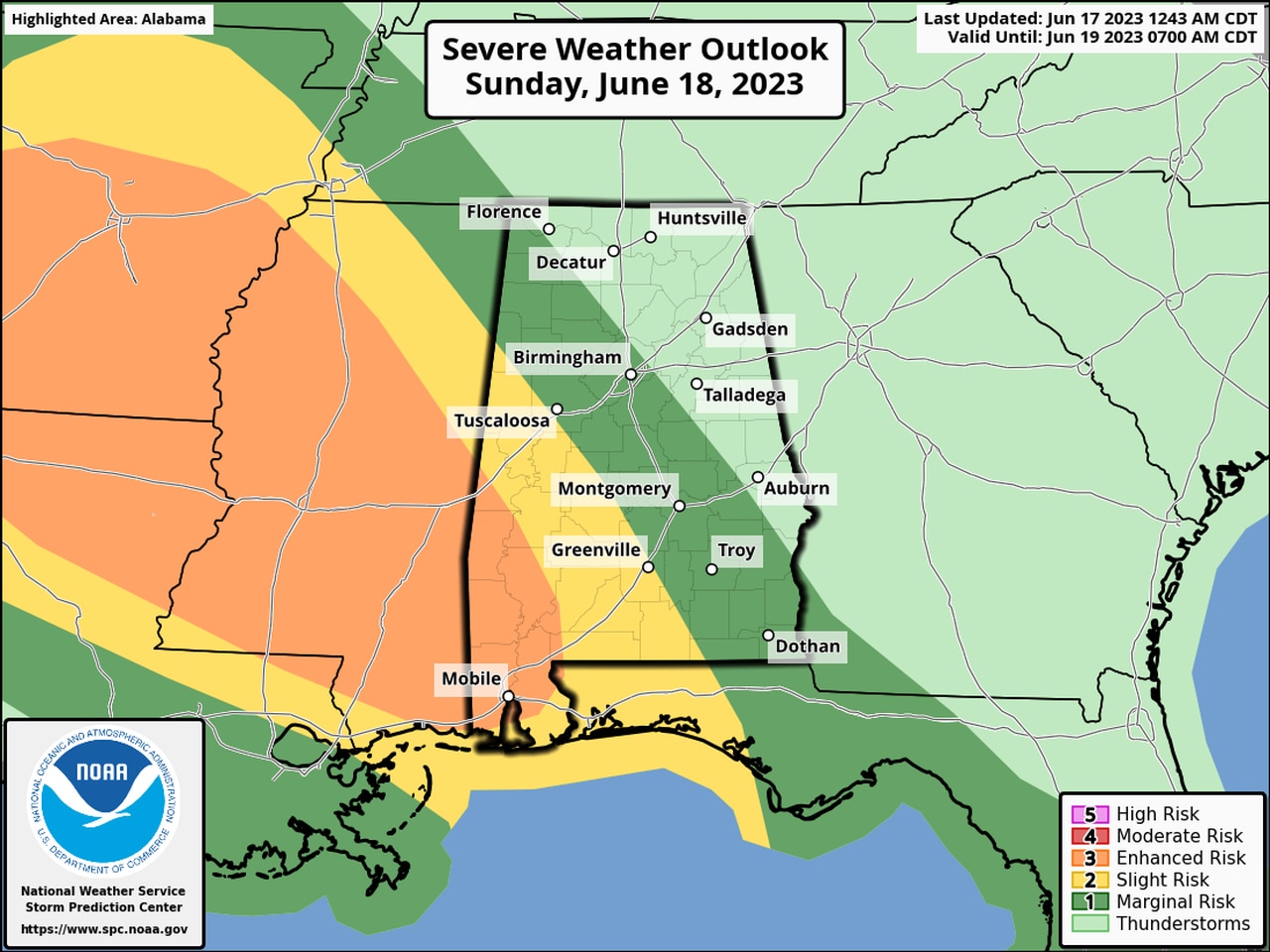
The Storm Prediction Center has added a Level 3 (enhanced) risk for part of west Alabama for Sunday, which means that numerous severe storms will be possible.
Here is the forecast for Sunday:
A Level 3 risk for severe weather is in the forecast for part of southwest Alabama for Sunday.
Monday’s severe weather threat is more uncertain, but a Level 1 risk is in the forecast for now. The timing is also uncertain, according to the weather service, and will be refined in the coming days.
As of now the southern-two thirds of Alabama could see isolated severe storms on Monday.
Here is the outlook for Monday:
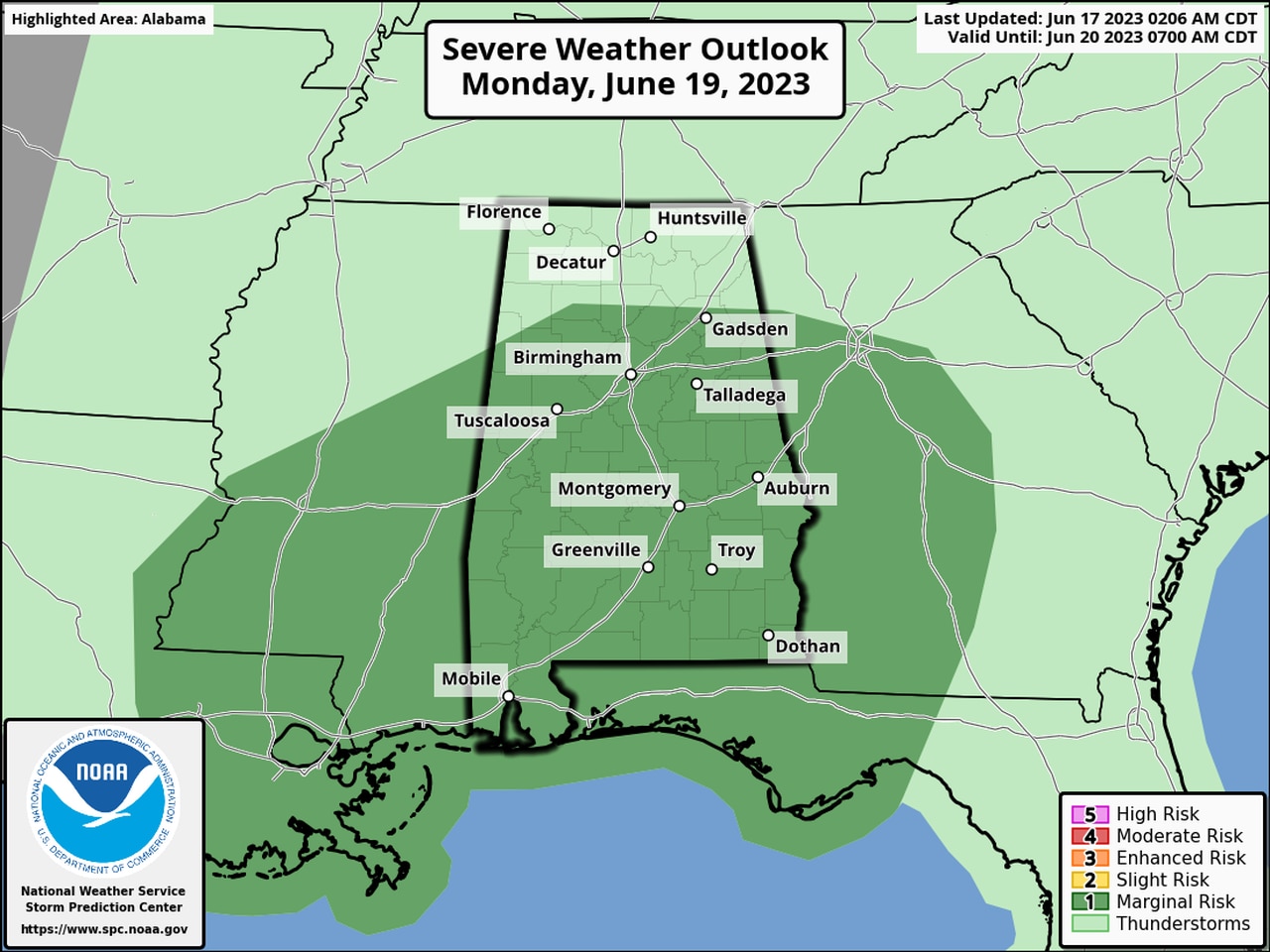
The southern two-thirds of Alabama could see isolated severe storms on Monday.
The strongest storms on both Sunday and Monday could bring more of the same: damaging winds, hail and heavy rain.