Hurricane season 2023: An early look at what to expect
The official start of the 2023 hurricane season is just days away.
June 1 is the start day for the Atlantic basin, which includes the Gulf of Mexico and the Caribbean. The season will last until Nov. 30.
NOAA hasn’t issued its official hurricane season outlook yet. That will come next Thursday, May 25.
Hurricane season 2023: What are this year’s storm names?
However, other groups have put a toe in the water and issued forecasts. The veterans of that group are the researchers at Colorado State University. CSU has been doing early hurricane season forecasts for three decades now.
The CSU early-season forecast, released in April, is suggesting the Atlantic could be in for a slightly-below-average season as far as the number of storms goes.
El Nino is a big player in many of the early hurricane season forecasts.
El Nino is a climate phenomenon characterized by warmer-than-average waters near the equator in the Pacific. Those warmer waters can cause a chain reaction of weather effects worldwide.
And it can have a big impact on the Atlantic hurricane season.
NOAA’s Climate Prediction Center is thinking that El Nino is likely to develop over the summer and hang around through the winter months. An El Nino watch is in effect for that reason.
“It’s looking highly likely that we’re going to have an El Nino through the hurricane season,” said Jason Beaman, the meteorologist in charge at the National Weather Service in Mobile.
“We’re pretty close to an El Nino now. The waters of the equatorial Pacific are warming really fast. So it’s not a certainty, but there are high probabilities that we’re going to have an El Nino through the hurricane season, which is a big difference from the past three seasons where we had La Nina.
“I was actually looking at some probabilistic forecast information and I think we’re up to an 80, 90 percent chance of El Nino during the heart of hurricane season. So we’re getting pretty high confidence that that’s going to be a significant factor this season,” he continued.
Why is that a big deal when it comes to hurricanes?
“Typically with El Ninos we have more wind shear in the Atlantic basin, more hostile conditions for development, so we tend to see the total number of storms below normal, maybe a lot below normal depending on the strength of El Nino, in the Atlantic basin,” Beaman said.
But El Nino ruling over the 2023 hurricane season isn’t a lock just yet, he added.
“Something that’s offsetting that is the Atlantic water temperatures across the entire Atlantic basin are really well above normal, for the most part,” Beaman said. “And with that type of signal sometimes that can tend to give a little bit of a boost to potential activity. The big question, the big uncertainty, is it going to be enough to offset the negative influences of El Nino?”
NOAA will weigh in on that question when its forecasters issue their 2023 Atlantic hurricane season outlook next Thursday.
Beaman cautioned Alabamians not to let their guard down if the forecast calls for a slow hurricane season. And he has evidence to back up his concern.
“I always use Hurricane Danny from 1997 for this type of season, an El Nino season,” he said. “1997 was the strongest El Nino on record. Well, Danny formed just off the coast of Louisiana in July and then proceeded to stall in Mobile Bay and produce historic flooding across our area as a Category 1 hurricane. So, again, that was the only storm in the Gulf that year. El Nino (produced) a well- below-normal season, but we got a big storm.”
Insert here the meteorologist’s mantra for hurricane season: It only takes one.
“The seasonal outlooks, while they are a great point of discussion — hey, it gets us talking, fantastic — but it can’t speak to local impacts, and I think it’s important for people to understand that,” Beaman said.
ANYTHING NEW FOR THE 2023 SEASON?
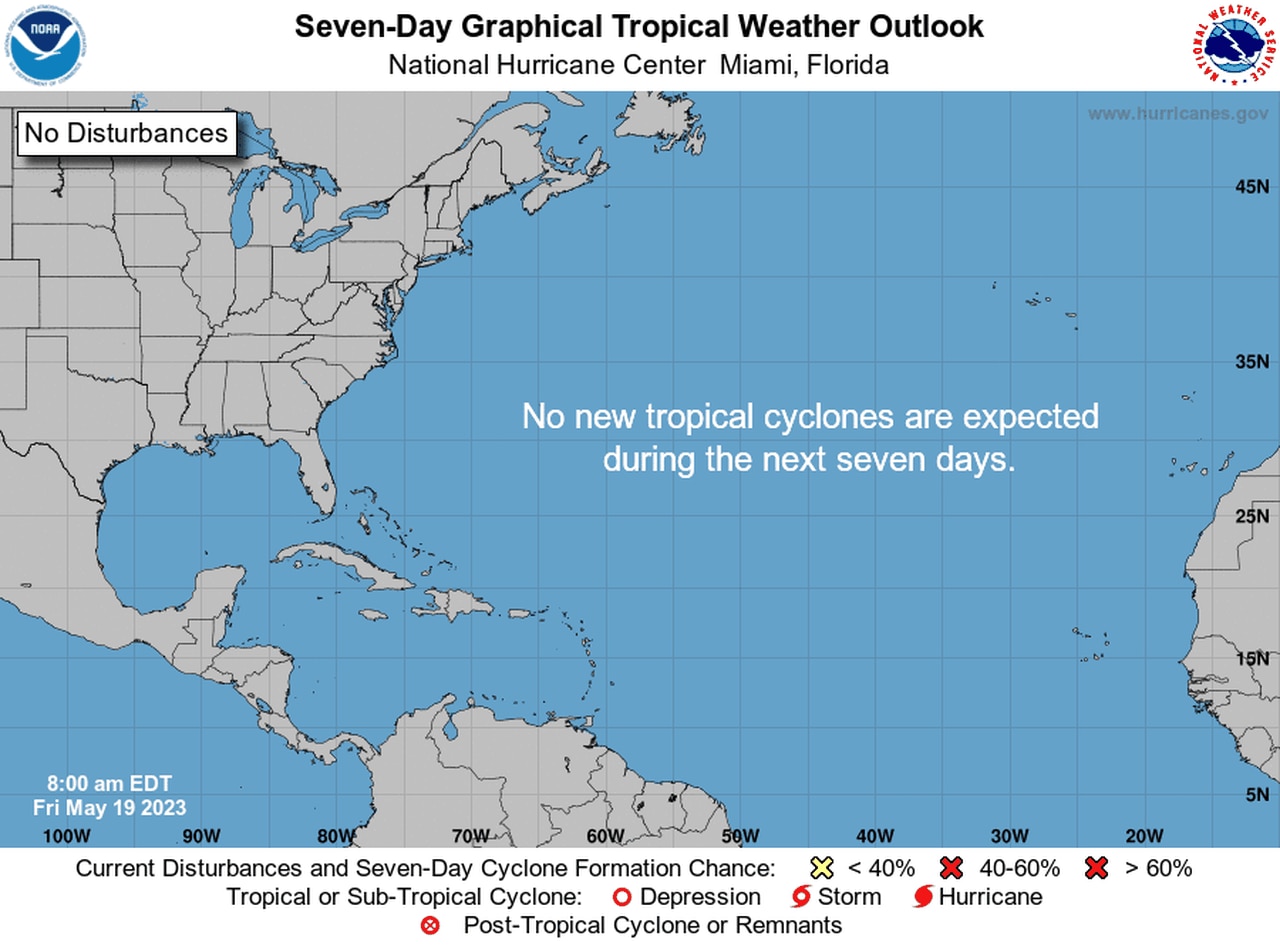
The tropical outlook is already up and running and now looks out seven days instead of five. Nothing to see in the Atlantic basin right now.
Beaman stressed that the thing for Alabamians to do now is go ahead and get prepared, just in case.
And the National Hurricane Center has added a new feature to help with that. Starting this year the hurricane center is offering a seven-day tropical outlook (previously it had been five days). The outlook highlights any areas of concern and tracks them in case they develop into more organized storms.
The extra two days of lead time is a good thing — but it could also be a stressful for some.
“The good thing is that we can be very aware of what is going on, have increased lead time, increased awareness — always a good thing,” Beaman said.
“There also could be some messaging fatigue with that … understand that at seven days out there is still a lot of uncertainty. So some of these storms could fizzle out, and some will go on to become tropical storms and hurricanes. If you hear about a potential storm seven days out, don’t get overly stressed about it. A lot could happen; a lot could change. But stay updated. I think it’s important for people to keep that in the proper context, because it could be a long season.”
LET’S TALK ABOUT THE CONE
The hurricane center will also continue to use what’s sometimes called the “cone of uncertainty,” or the product that shows where forecasters think a storm will go.
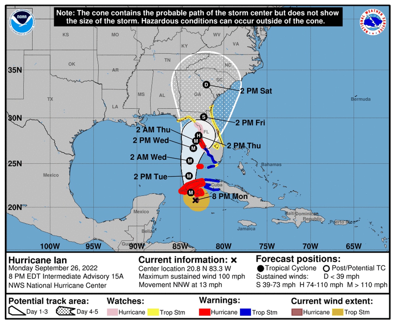
The cone faced extra scrutiny during the 2022 season when Hurricane Ian slammed into southwest Florida on Sept. 28 as a top-end Category 4 storm. Ian’s track shifted during its approach to Florida, and it led to some confusion — and criticism.
Here’s one of the early tracks for Ian, which ended up making landfall farther south near Punta Gorda:

Hurricane Ian was a catastrophic storm for southwest Florida in 2022. This is an early track for the storm, which ended up making landfall on Sept. 28, 2022, farther to the south.
“The cone is a tool in the toolbox for the public to use as a piece of information, but it can’t be the only tool you use,” Beaman said.
“The cone, all that is showing you is where the center of that particular storm is likely to be 66 percent of the time. It also means that a third of that time it could drift outside of that cone. Again, it’s only talking about the center, and I think this is where a lot of people get confused and where some misinterpretation happens.”
Areas within the cone aren’t the only ones that could feel the effects of a storm, he said.
“Do not take it for a cone of impact. A hurricane can be several hundred miles across, producing multiple hazards,” he said.
“What I would like to see and encourage our public (to do) is changing the gears of our typical tropical mindset. Yes, we look at the cone. Yes, I know people want to know what category the storm is, but I want there to be less focus on that — easier said than done I know — let’s put more focus on the watches and warnings that are issued and in effect and the potential local impacts that are being discussed.”
WHAT TO DO NOW
Beaman said now is the time to get ready. That will greatly reduce your stress levels if a storm happens to come your way.
What can you do now to prepare?
“Doing the simple things around our house … trees that are hanging around the house, can we trim them back? Is there a diseased tree that you’re worried about that could fall in a storm — anything we can do in mitigation measures to prepare and limit damage during these storms the better,” he said.
Come up with a plan and know what you’ll do and where you will go if you need to evacuate.
“We always talk about how every family needs to have a plan,” he said. “You need to know if you are in an evacuation zone and you need to know what you will do if an evacuation order is called. The more you do now, the less stress it’ll be for you and your family.”
And don’t forget about after the storm — which has proven to be just as deadly.
“There could be prolonged power outages. How would you handle that?” Beaman said.
“If you get a backup generator, know how to use it properly because a lot of people get in trouble and we’ve had a lot of fatalities in this country over the past several years with improper generator use.”
Beaman also encouraged those near the coast to become familiar with their local emergency management agency.
“They have tons of resources and information to let you know what the evacuation zones are. Tap into those resources now, get familiar now, because the more prepared you are now, it all goes back to that stress,” he said.
“Hurricanes are a stressful time, so what can we do to mitigate that stress ahead of time so we can make better decisions in the heat of the moment, so to speak.”
