Hurricane Idalia strengthens into Category 4 storm
Powerful Hurricane Idalia tracked closer to Florida’s Gulf Coast early Wednesday morning as a Category 4 monster with 130 mph winds.
The National Hurricane Center said Idalia could continue to strengthen up until landfall later this morning — an unfortunate trait of recent Gulf storms.
Forecasters warned that “catastrophic” storm surge and destructive winds are expected in the area over the next few hours.
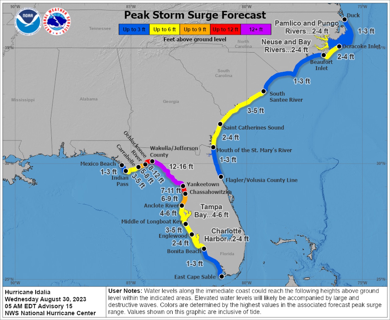
The surge along part of the Florida coast could be as high as 12 to 16 feet above what’s normally dry ground. Winds are expected to cause destruction and widespread power outages, and there could be nearly a foot of rain in some areas.
As of 4 a.m. CDT Wednesday, the center of Hurricane Idalia was located about 60 miles west of Cedar Key, or 90 miles south of Tallahassee, and was moving north-northeast at 18 mph.
Idalia had 130 mph winds, making it a Category 4 hurricane. The hurricane center said that Idalia could even strengthen more before it makes landfall in a few hours.
Hurricane warnings stretched along the Florida coast, and watches and warnings were also accumulating along the Atlantic coast as well.
Idalia is not expected to bring major impacts to Alabama, though areas in the southeast corner of the state stand to see heavy rain and gusty winds as the storm moves inland today. There will also continue to be a high risk for rip currents along the coast, and beachgoers are encouraged to stay out of the water.
Forecasters said that Idalia is likely to still be a hurricane while it tracks across southern Georgia, and possibly when it reaches the coast of Georgia or southern South Carolina late today.
The hurricane center said that after landfall, Idalia is forecast to turn toward the northeast and east-northeast, moving near or along the coasts of Georgia, South Carolina, and North Carolina late today and Thursday.
Idalia could also bring a few tornadoes from the coast of west-central Florida northward into the Florida Big Bend region, the hurricane center said. The tornado risk will move into Georgia and the coastal Carolinas later today.
Here is the surge forecast for Idalia as of Wednesday morning:
Idalia could bring catastrophic storm surge of 12 to 16 feet to parts of Florida’s Gulf Coast.
Here are the watches and warnings for Idalia as of Wednesday morning:
* A Storm Surge Warning is in effect from Englewood northward to Indian Pass, including Tampa Bay, and from St. Catherine’s Sound to South Santee River, S.C.
* A Hurricane Warning is in effect from the middle of Longboat Key northward to Indian Pass, including Tampa Bay.
* A Tropical Storm Warning is in effect from Chokoloskee northward to the Middle of Longboat Key, from west of Indian Pass to Mexico Beach and from Sebastian Inlet, Fla., to the North Carolina/Virginia border, and Pamlico and Albemarle Sounds.
* A Storm Surge Watch is in effect from Bonita Beach northward to Englewood, including Charlotte Harbor, from the mouth of the St. Mary’s River to South Santee River, S.C., from Beaufort Inlet to Drum Inlet, N.C., and the Neuse and Pamlico Rivers in North Carolina.
* A Hurricane Watch is in effect from the mouth of the St. Mary’s River to Altamaha Sound, and from Edisto Beach to South Santee River, S.C.
* A Tropical Storm Watch is in effect from north of Surf City, N.C., to the North Carolina/Virginia border and Pamlico and Albemarle Sounds.