Hurricane forecasters will be watching Gulf next week
The National Hurricane Center had its hands full as of Friday.
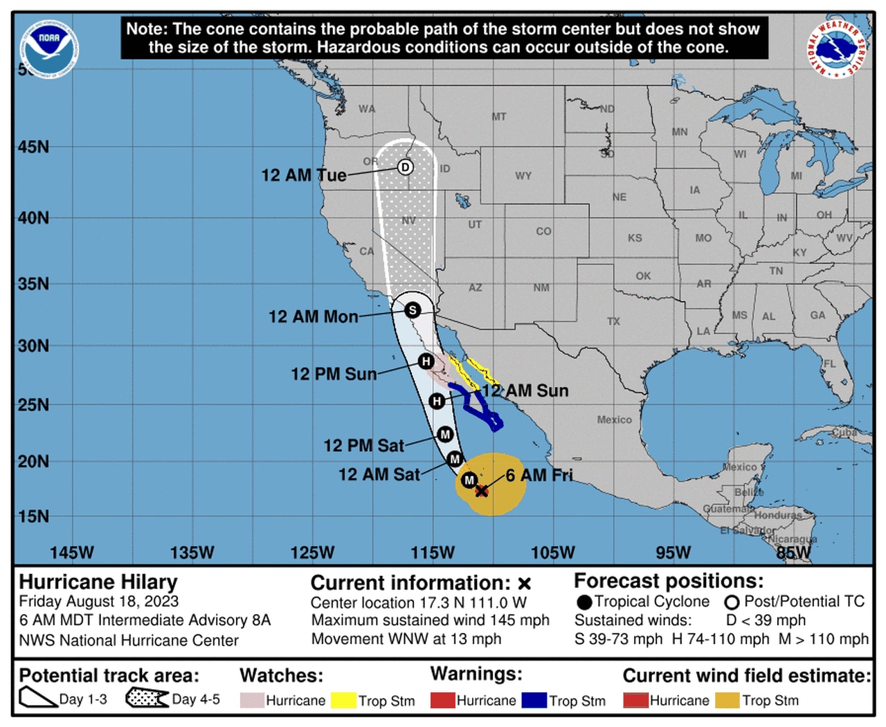
Forecasters were tracking powerful Category 4 Hurricane Hilary in the eastern Pacific, which is forecast to be a rare storm that moves very close to California.
Here’s the track forecast for Hilary, a track you don’t see every day:
Hurricane Hilary could bring widespread flooding to parts of California and the Southwest U.S.
Then, in the Atlantic, there are four disturbances that are being tracked. And one of them will make it into the Gulf of Mexico early next week.
That disturbance was located just north of Hispaniola on Friday morning but will eventually make it into the Gulf, according to forecasters.
The hurricane center said an area of low pressure could then form, and some slow development will be possible as the system heads toward the western Gulf Coast (Texas and Mexico) by the middle of next week.
The system is not expected to threaten Alabama.
The hurricane center gave that disturbance a 30 percent probability of becoming a tropical depression in the next week (which is unchanged from Thursday).
There were also three other disturbances being watched, but they were farther out in the Atlantic.
The one that is closest to becoming a tropical depression was in the eastern Atlantic, a few hundred miles west of the Cabo Verde Islands off Africa’s west coast. The hurricane center said the disturbance continued to look more organized, and a tropical depression could form over the weekend as the system tracks to the west-northwest or northwest.
This may not be a storm to worry about, however. Forecasters expect winds over the Atlantic to become unfavorable by early next week “and further development is not expected.”
The next disturbance was in the central Atlantic about halfway between the Cabo Verde Islands and the Lesser Antilles.
It was disorganized as of Friday morning, but there is a chance it could still develop and become a tropical depression over the next few days as it tracks to the west-northwest. Upper-level winds are also expected to become unfavorable for this disturbance and could limit any more development, the hurricane center said.
The last area to watch was to the east-southeast of the Lesser Antilles on Friday. The hurricane center said an area of low pressure could form over the weekend and could slowly develop over the weekend and into early next week as it tracks to the west-northwest.
That disturbance has a 30 percent chance of becoming a tropical depression in the next seven days.
The climatological peak of the Atlantic hurricane season is fast approaching on Sept. 10. NOAA is forecasting a busy season, with 12-17 named storms (that includes tropical storms and hurricanes), five to nine hurricanes and one to four major hurricanes (Category 3 or stronger storms).
That forecast includes storms that have already formed. There have been three tropical storms, one unnamed storm and one hurricane so far in 2023.
According to NOAA an average season in the Atlantic basin has 14 named storms, seven hurricanes and three major hurricanes.
