Hurricane forecasters keep close watch on Gulf
The Gulf of Mexico is expected to have to deal with another tropical system in the next few days.
The National Hurricane Center continued to track a tropical wave in the northwestern Caribbean Sea on Saturday — as well as Tropical Storm Franklin in the western Atlantic and two other tropical waves.
But it’s the system headed for the Gulf that is expected to affect the United States.
As of Saturday the soon-to-be Gulf system was getting more organized and in a good area to strengthen more. The hurricane center said a tropical depression was likely to form later this weekend or early next week as the system moves northward and into the eastern Gulf.
The hurricane center raised the probability of a depression forming to 90 percent as of Saturday morning.
Forecasters urged those along Mexico’s Yucatan Peninsula, western Cuba and Florida to keep a close eye on the system.
The next names on the Atlantic storm list, by the way, are Idalia (pronounced ee-DAL-ya), Jose and Katia.
The big questions are where will it go and how strong will it get? And there just are no sure answers as of Saturday, according to forecasters.
The thinking is that the system could end up affecting Florida — anywhere from the Big Bend area to the peninsula. But that’s not a sure thing by any means.
The National Weather Service in Mobile continued to watch the system and said on Saturday that it could at the very least increase the risk for rip currents along the Alabama and northwest Florida coasts next week.
Expect rain chances to increase as well — especially on Tuesday and Wednesday — with scattered to numerous storms expected.
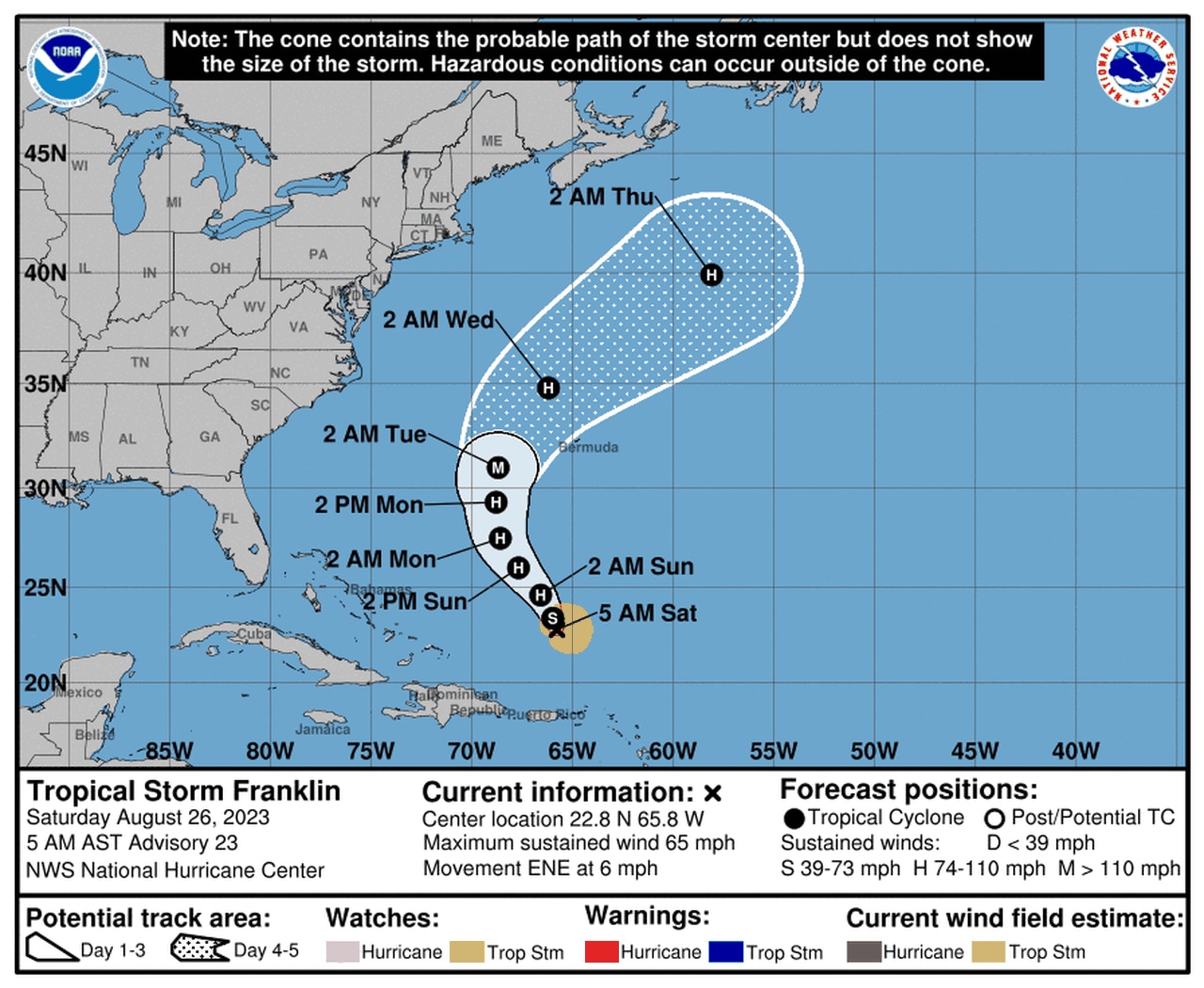
The hurricane center was also tracking Tropical Storm Franklin, which is not expected to directly affect the U.S. but will need to be watched by those in Bermuda.
Franklin could become a hurricane soon.
Franklin had 65 mph winds as of early Saturday morning and was expected to become the second hurricane of 2023 in the Atlantic in the next few days (the first one was Don). The hurricane center’s intensity forecast shows Franklin possibly peaking as a Category 3 hurricane with 115 mph winds in a few days.
Franklin was located 660 miles south of Bermuda early Saturday morning and is forecast to take a sharp turn to the north starting later today. The center of the storm is forecast to pass west of Bermuda by Tuesday.
The hurricane center was also tracking a tropical wave in the central Atlantic that could become a tropical depression soon but is no threat to land.
Another tropical wave that could develop was expected to move off Africa’s west coast by early next week and track westward.
