Hurricane expected to hit Florida Gulf coast this week
A tropical depression headed for the Gulf of Mexico is expected to become Tropical Storm Idalia today, according to the National Hurricane Center.
It could become a hurricane by Tuesday, and there are some signs that it could strengthen more than presently forecast.
Tropical Depression 10 was in the northwestern Caribbean near Cozumel, Mexico, on Sunday morning and is forecast to take a path northward and enter the eastern Gulf on Monday.
It is expected to become a hurricane by Tuesday, and the forecast path shows it making landfall somewhere on Florida’s Gulf Coast by Wednesday. The so-called “cone of uncertainty” has narrowed and shows that the center of the storm could make landfall anywhere from Panama City to Tampa, with the center of the cone focused on Florida’s Big Bend region.
But it should be noted that heavy rain and winds from the storm will be felt far outside the cone, which only shows where the center of the storm is forecast to go.
Alabama’s coast is not included in the cone as of Sunday morning, but part of southeast Alabama is. The National Weather Service offices in Mobile and Birmingham were keeping a close eye on the storm in case the track shifts and the potential for more significant effects become possible in the state. The storm will bring an increased risk for rip currents to the Alabama coast this week.
The weather service in Mobile urged those along the Alabama and northwest Florida coasts to stay alert: “No watches or warnings are in effect for our area at this time. No local impacts are expected through Monday. High risk of rip currents and high surf are expected to ramp up late Tuesday through Thursday. Please continue to closely monitor the progress of this system over the next few days and DO NOT LET YOUR GUARD DOWN.”
The hurricane center noted two things in its Sunday morning forecast discussion: The forecast track is still very uncertain because of the erratic movement of the system so far, and there is the potential that it could quickly intensify once it makes it into the record-warm waters of the Gulf of Mexico.
Right now the storm is forecast to peak as a Category 1 hurricane with winds up to 90 mph.
Those along the Florida coast are being urged to get their supplies and their plans in order as soon as possible.
The hurricane center said several reconnaissance flights planned today will give forecasters invaluable data to help better calculate the storm’s potential path and eventual intensity.
But forecasters noted some troubling trends in overnight computer model forecasts.
The hurricane center noted that “there’s a notable risk of rapid intensification while the system moves across the record warm eastern and northeastern Gulf of Mexico, which is highlighted by the recent HAFS and HWRF guidance. The new NHC forecast is raised from the previous one, near or above the model consensus, and could be too low. I’m reluctant to make any big changes to the forecast until we get more in-situ data, but the upward overnight model trend certainly bears watching. Users are reminded to continue monitoring forecasts for any changes to the system’s expected intensity as it approaches Florida.”
The storm is forecast to track across northern Florida, then into Georgia and could emerge into the Atlantic off the coast of the Carolinas, spreading heavy rain and gusty winds far inland across the Southeast.
As of 7 a.m. CDT Sunday, the center of Tropical Depression Ten was located about 70 miles southeast of Cozumel, Mexico, and was moving southeast at 5 mph.
The depression had sustained winds of 35 mph. It needs winds of at least 39 mph to become Tropical Storm Idalia, and that is expected to happen sometime today.
Tropical storm warnings continued along parts of Mexico’s Yucatan Peninsula and western Cuba, and tropical storm watches were also in effect for parts of Cuba.
The storm could bring a lot of heavy rain to areas in its path. For Florida, the hurricane center is forecasting 3 to 6 inches with the potential for up to 10 inches for areas along the west coast and Panhandle as well as southern Georgia.
HURRICANE FRANKLIN
Hurricane Franklin could become a Category 3 storm as soon as tonight but is not a direct threat to the U.S.
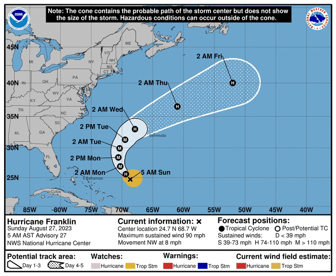
The hurricane center also continued to track a strengthening Hurricane Franklin on Sunday.
Franklin poses no direct threat to the U.S., but it will track close to Bermuda this week.
Franklin is also forecast to strengthen into 2023′s first major hurricane and could become a Category 4 storm before it’s done.
As of early Sunday morning Hurricane Franklin was located about 575 miles south-southwest of Bermuda and was moving northwest at 8 mph.
The center of the storm is expected to pass west of Bermuda in three or four days, forecasters said.
Franklin was a Category 1 hurricane with 90 mph winds as of Sunday morning. The hurricane center said Franklin could become a Category 3 hurricane as soon as tonight. It could peak as a Category 4 hurricane later this week with winds as high as 130 mph.
Franklin could generate deadly rip currents along the southeast coast of the U.S. this week.
