Heat advisories for nearly all of Alabama for Thursday
All by two Alabama counties will be under heat advisories on Thursday, and temperatures could crack the triple digits in a spot or two.
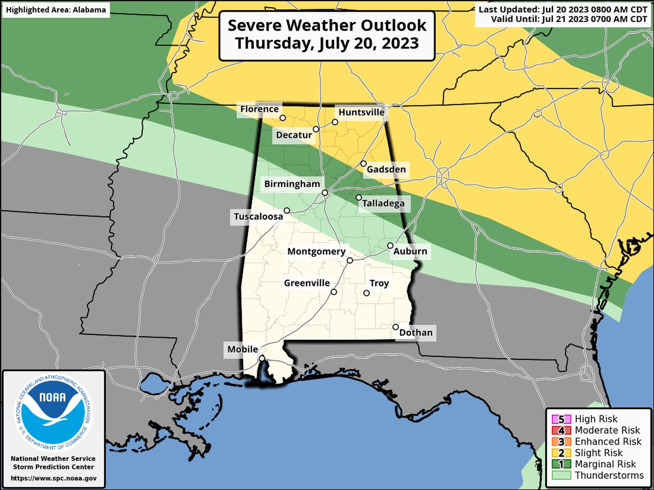
There will also be a risk for severe weather for the northern part of the state.
The National Weather Service said the heat index, or “feels like” temperature, could climb as high a 112 in some areas this afternoon.
Air temperatures are expected to be in the mid- to upper 90s statewide, and that combined with an oppressive blanket of humidity will make it feel even hotter.
Use extra caution if you will be working outside today for long periods.
There is also a chance for severe storms later this afternoon. NOAA’s Storm Prediction Center thinks scattered severe storms will be possible in the northeast corner of the state, and there is a Level 2 out of 5 severe weather risk there.
The rest of north Alabama and part of central Alabama has a Level 1 risk and could have to deal with isolated severe storms.
Here’s the severe weather outlook for today:
Areas in yellow will have a Level 2 risk for severe weather today. Areas in dark green will have a Level 1 risk.
The strongest storms could have damaging straight-line winds, hail and heavy rain. Confidence is low on the timing, according to the weather service, but the most likely time for storms will be this afternoon into tonight.
Here is a look at the heat advisories that have been issued for Alabama by region:
NORTH ALABAMA
* Heat advisory from 11 a.m. until 8 p.m. Thursday for Lauderdale, Colbert, Franklin, Lawrence, Limestone, Madison, Morgan, Marshall and Cullman counties.
The National Weather Service in Huntsville said heat index values of 105-109 are expected.
CENTRAL ALABAMA
* Heat advisory in effect until 9 p.m. for Pickens, Tuscaloosa, Jefferson, Shelby, Sumter, Greene, Hale, Perry, Bibb, Chilton, Coosa, Tallapoosa, Chambers, Marengo, Dallas, Autauga, Lowndes, Elmore, Montgomery, Macon, Bullock, Lee, Russell, Pike, Barbour, Marion, Lamar, Fayette, Winston, Walker, Blount, St. Clair, Talladega, Etowah, Calhoun, Cherokee, Cleburne, Clay, and Randolph counties.
The National Weather Service in Birmingham said the heat index could climb as high as 109 in those areas this afternoon.
SOUTH ALABAMA
* Heat advisory from 11 a.m. until 7 p.m. for Choctaw, Washington, Clarke, Wilcox, Monroe, Conecuh, Butler, Crenshaw, Escambia, Covington, Mobile and Baldwin counties.
The National Weather Service in Mobile said the heat index could climb to between 105 and 110 degrees in those areas this afternoon.
* Another heat advisory will be in effect from 11 a.m. until 7 p.m. CDT Thursday for Coffee, Dale, Geneva, Henry and Houston counties.
The National Weather Service in Tallahassee, Fla., said that the heat index could reach up to 112 today.
There could be one more hot day coming before temperatures cool down a bit this weekend.
Here are the projected highs for Friday:
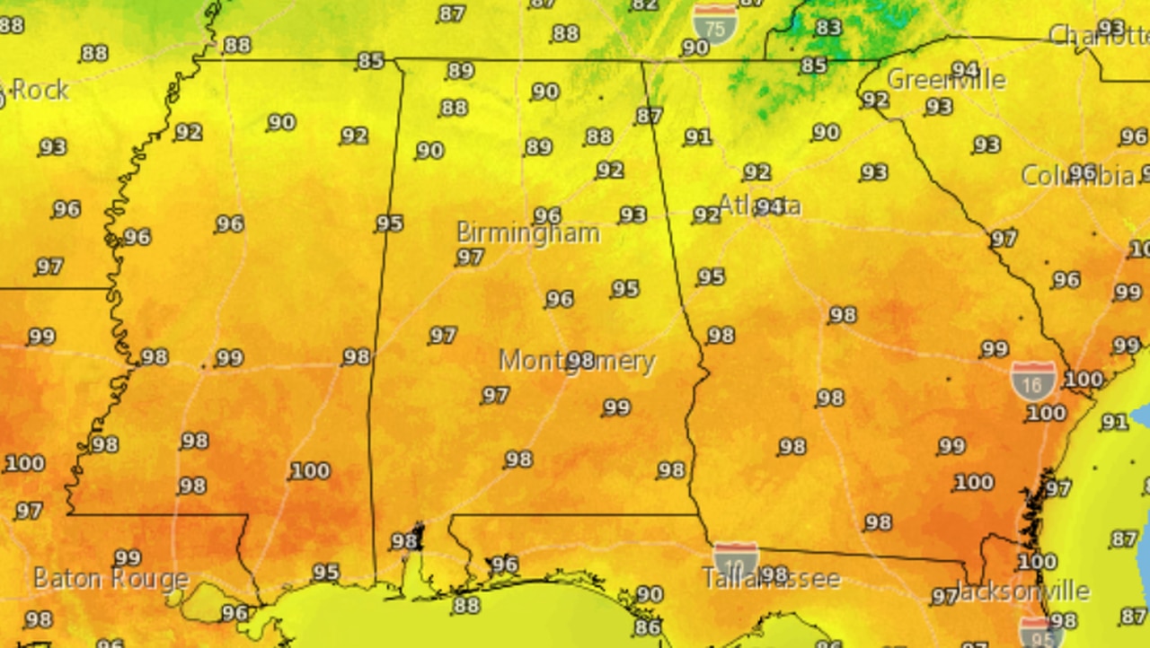
Here are the forecast highs for Friday.
Heat levels are expected to come down by Saturday for most of the state and over the weekend. It will still be hot in south Alabama, however, with highs expected to still be in the mid-90s
Here is the forecast for Saturday:
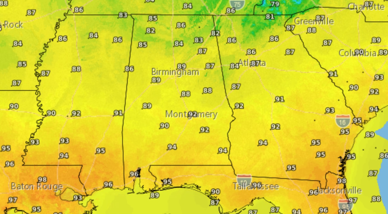
Highs could dip back down in the 80s for parts of Alabama on Saturday.