Heat advisories and severe storms in Alabama forecast
Alabama will have triple-digit heat index values and the chance for severe storms today.
The National Weather Service has issued a heat advisory for Friday for western Alabama, where the heat index, or “feels like” temperature, could climb above 105 this afternoon.
And there could also be a few strong to severe storms in the mix.
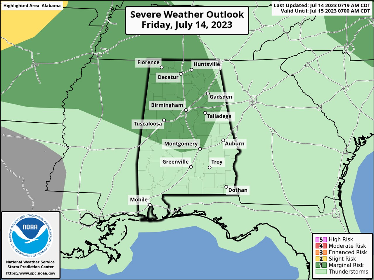
NOAA’s Storm Prediction Center has a Level 1 out of 5 risk for severe weather in place for most of north and central Alabama today. A Level 1 risk means that isolated severe storms will be possible.
The strongest storms today could have damaging straight-line winds. Tornadoes are not expected.
And there could also be some flooding rain, and a flood watch will be in effect for the southeast corner of the state today.
That’s a lot of weather for one state. Here’s a look at the different impacts possible today.
HEAT ADVISORY
High temperatures in Alabama are expected to climb into the 90s nearly statewide today. Combine that with very high humidity levels (even for Alabama) and you get “feels like” temperatures that could lead to heat illnesses.
* A heat advisory will be in effect from 10 a.m. until 9 p.m. Friday for the central Alabama counties of Lamar, Fayette, Walker, Pickens, Tuscaloosa, Sumter, Greene, Hale, Perry, Bibb, Chilton, Marengo, Dallas, Autauga, Lowndes, Elmore and Montgomery.
The weather service said heat index values up to 106 are expected.
* Another heat advisory will be in effect from 11 a.m. until 7 p.m. Friday for the southwest Alabama counties of Choctaw, Washington and Mobile.
The weather service said heat index values of 107 to 110 will be possible.
SEVERE WEATHER
A Level 1 risk for severe weather is in place on Friday for the areas in dark green.
There is a Level 1 risk for severe weather for much of north and central Alabama today, which means that isolated severe storms will be possible. Rain and storms will also be possible across the rest of Alabama today.
Storms are most likely this afternoon and tonight. The strongest could have damaging winds and heavy rain, which will be a concern for areas in western Alabama that were hit with considerable flash flooding on Thursday. Excessive rainfall is also a concern for southeast Alabama.
Storms are expected to be slow-movers like those on Thursday, which could lead to a lot of rain falling in a short amount of time.
Forecasters will be watching in case a storm complex forms to the west and tracks into the state later today.
More rain and storms will be possible in Alabama on Saturday, but as of now the SPC has no severe weather risk for Alabama.
FLOODING
Flooding will continue to be a concern in parts of Alabama, mainly in the west and southeast.
The National Weather Service has issued a flood watch for the southeast corner of the state, including the counties of Coffee, Dale, Geneva, Henry and Houston. It will be in effect through Saturday evening.
The weather service said excessive rainfall will be possible during that time.
NOAA’s Weather Prediction Center will also be on the lookout for flooding and has a Level 2 out of 4 risk for flash flooding across a good chunk of the state. The rest of Alabama will have a Level 1 risk today.
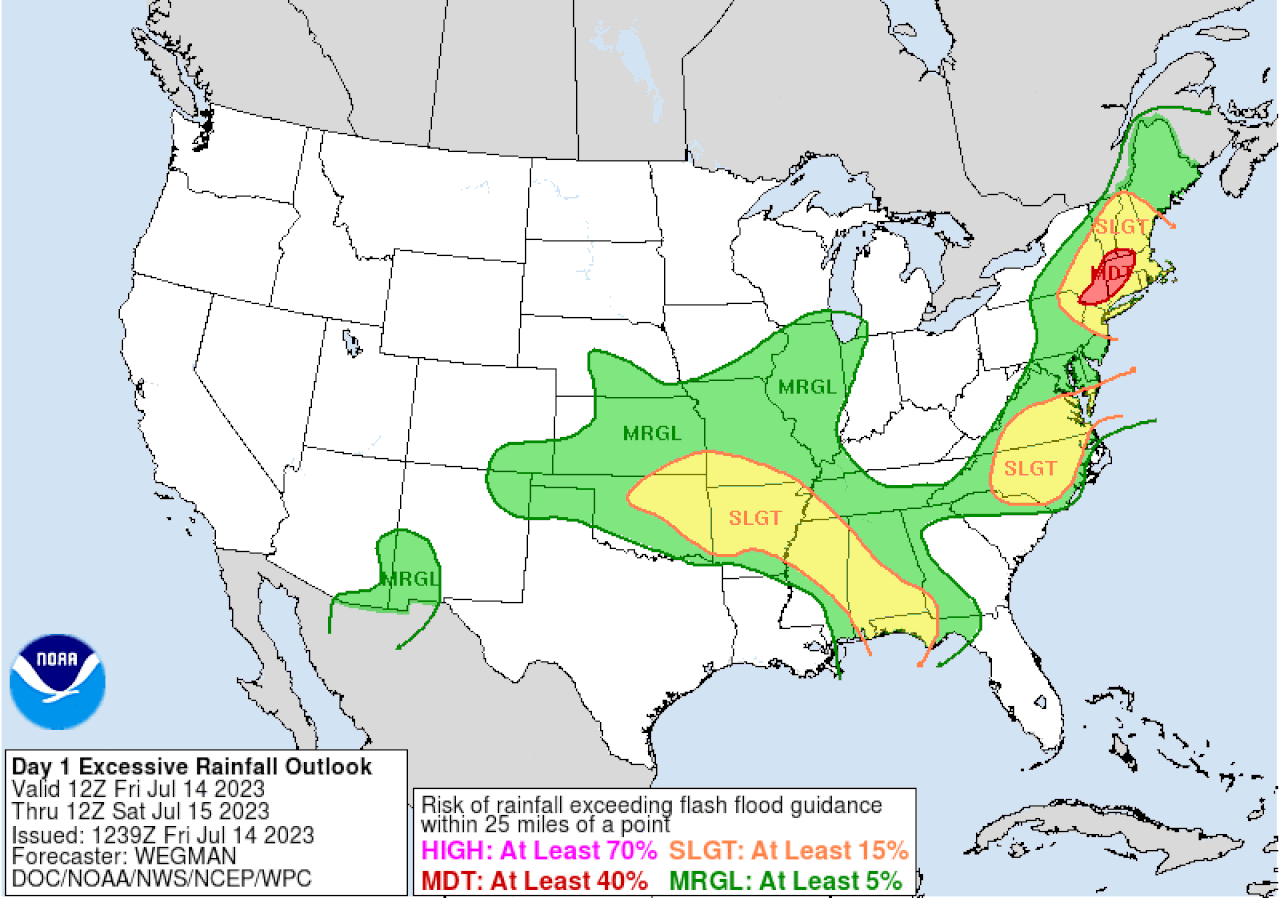
Flash flooding will again be a concern in Alabama on Friday. This is the excessive rainfall outlook for Friday. Areas in yellow have a Level 2 out of 4 risk for flash flooding. Areas in green have a Level 1 risk.