Forecasters watching for next tropical storm in Atlantic
The tropical Atlantic Ocean continued to be busy early Tuesday as the peak of the 2023 hurricane season neared.
There were no named storms, for the first time in a while, but that could change in the next day or two.
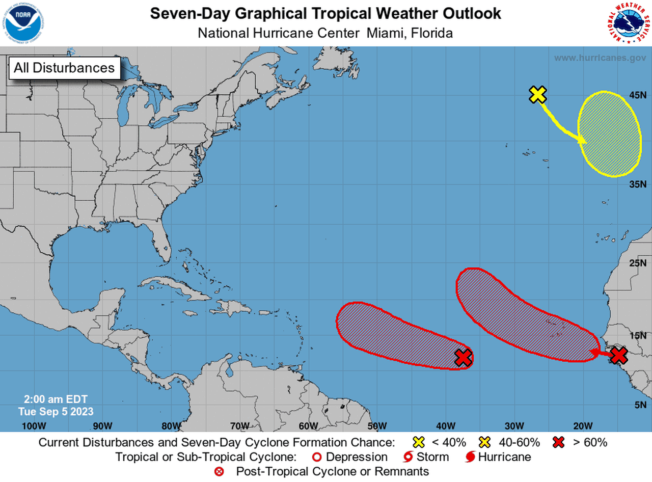
The National Hurricane Center continued to track a well-organized tropical wave that is expected to become a tropical depression or tropical storm soon. If it gets a name it will be Lee.
Forecasters expect the potential Lee to strengthen and possibly become a hurricane later this week as it heads westward in the central Atlantic.
It’s too soon to say if the storm could affect the United States, but its path is being tracked very closely by the hurricane center and those along the U.S. East Coast.
The hurricane center’s forecast path takes the storm in the general direction of the Leeward Islands, but many forecast models steer it near the islands or to the north of them — which could keep it out of the Caribbean.
However, it’s too soon to say if that forecast track will become reality.
The hurricane center said the disturbance was located about 900 miles west-southwest of the Cabo Verde Islands early Tuesday and was tracking to the west-northwest at 15 to 20 mph.
Forecasters said it continued to look more organized, and a tropical depression or storm is expected to form over the next day or so.
The hurricane center added that “additional strengthening, possibly to a hurricane, is likely later this week while the system moves over western portions of the tropical Atlantic, near or to the northeast of the northern Leeward Islands.”
The hurricane center was also tracking a second tropical wave expected to move off the coast of Africa that could also become a depression this week. However it is expected to take a more northwesterly track. That is bad news for the Cabo Verde Islands, which could wind up in its path and get wind and rain from the storm. However, after its brush with the islands the system could head out to sea and not affect any other land areas.
Forecasters are also watching the remnants of former Hurricane Franklin, now over the north-central Atlantic several hundred miles north of the Azores. That system was forecast to track to the southeast and over warmer water. It could try to regenerate later this week or this weekend and is expected to move “erratically” between the Azores and Portugal.
It has a 20 percent chance of becoming a tropical depression in the next seven days.
The hurricane center on Monday ruled that former Tropical Storms Gert and Katia had lost their tropical features.
There have been 11 named storms and one unnamed storm so far this year. Three of those storms (Don, Franklin and Idalia) have strengthened to hurricanes, and two of those — Franklin and Idalia — became major hurricanes (both were Category 4 storms).
NOAA is forecasting 12-17 named storms to form before the season ends (that includes tropical storms and hurricanes), five to nine hurricanes and one to four major hurricanes (Category 3 or stronger storms).
According to NOAA an average season in the Atlantic basin has 14 named storms, seven hurricanes and three major hurricanes.
