Coldest temperatures in âdecadesâ possible in parts of Alabama tonight
Parts of Alabama woke up to snow, ice and very cold temperatures on Tuesday. And the National Weather Service is warning those in part of the state that the coldest temperatures in “decades” will be possible tonight and into Wednesday.
The snow and freezing rain was over for north and parts of central Alabama as of Tuesday morning, but freezing rain was still falling in parts of south Alabama, where winter weather advisories were still in effect.
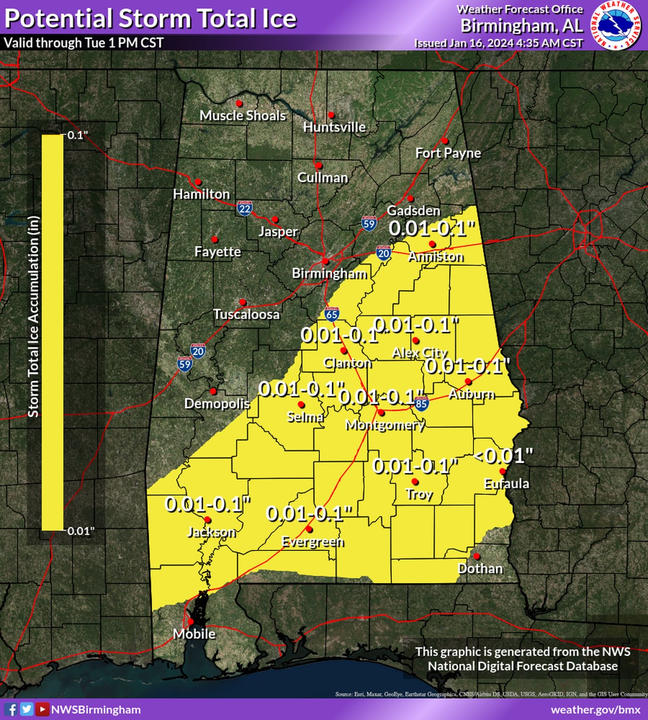
Here is the forecast for additional ice accumulations through the morning:
Here are the potential ice accumulations through this afternoon.NWS
The weather service warned Alabamians to only travel if necessary, keep devices charged, check on neighbors and bring pets indoors.
Highs today will not make it above freezing in a large part of the state, which will allow any frozen precipitation that has fallen to stick around into Wednesday.
Here are the forecast highs for Tuesday:
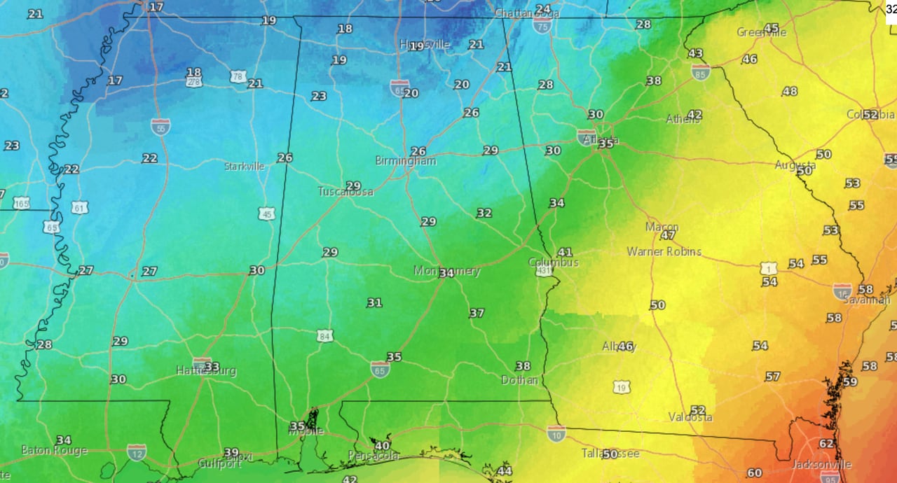
Here are the forecast highs for Tuesday.NWS
Then the coldest night of the winter is in store for all of Alabama tonight.
The weather service said morning lows in north Alabama are expected to fall into the single digits — or could even go below zero — and wind chills could make it feel like 5 to 15 degrees below zero.
Wind chill advisories and hard freeze warnings will be in effect for much of the state.
Another weather system is expected to move into Alabama Thursday night into Friday, bringing with it another chance of precipitation. As of Tuesday morning forecasters think the chances of additional accumulating wintry precipitation are low.
More dangerous cold temperatures are expected this weekend.
Here’s a look at what the National Weather Service is expecting statewide:
NORTH ALABAMA
The National Weather Service in Huntsville said north Alabama is facing dangerously cold temperatures and wind chills through Wednesday morning. Wind chill warnings and advisories are in effect for the region.
Low temperatures tonight could fall to the single digits or even below zero, and wind chills could make it feel anywhere from 5 to 15 degrees below zero.
The weather service also said temperatures could possibly get above freezing briefly on Wednesday before falling again, which could refreeze any liquid on surfaces on Wednesday night.
Forecasters are also looking at the weather on Thursday and Friday, when rain could arrive and transition to a wintry mix on Thursday night. Forecasters said the chances for snow or ice are low at the moment.
More extreme cold is anticipated this weekend.
* Wind chill warning for Lauderdale, Colbert, Franklin, Lawrence, Limestone and Madison counties until 9 a.m. Wednesday. The weather service said wind chills as low as 10 to 15 below zero will be possible.
* Wind chill advisory for Morgan, Marshall, Jackson, DeKalb and Cullman counties until 9 a.m. Wednesday. Wind chills as low as 5 to 10 below zero will be possible.
CENTRAL ALABAMA
The National Weather Service said a mix of rain and wintry precipitation continued across southeastern portions of the central Alabama this morning.
The wintry precipitation and rain will continue to move southeast over the next few hours and could cause some minor ice accumulation and slick conditions along and south of the Interstate 85 corridor as temperatures continue to fall.
Forecasters said slick and icy roadways are expected to persist through the day for most of the area with only a brief opportunity for roads to dry this afternoon. Most locations north and west of I-85 will remain below freezing for the entire day, and bitterly cold temperatures are expected areawide tonight. As such, slick roadways may persist into Wednesday morning.
* Hard freeze warning until 10 a.m. Wednesday for Marion, Lamar, Fayette, Winston, Walker, Blount, Etowah, Calhoun, Cherokee, Cleburne, Pickens, Tuscaloosa, Jefferson, Shelby, St. Clair, Talladega, Clay, Sumter, Greene, Hale, Perry, Bibb, Chilton, Coosa and Marengo counties.
The weather service said temperatures will range from around 8 degrees in the northwest to 20 degrees in the central part of the region this morning, then remain at or below freezing in many areas this afternoon, and drop into the 0 to 10 range tonight.
* Hard freeze warning from 8 p.m. Tuesday until 10 a.m. Wednesday for Randolph, Tallapoosa, Chambers, Dallas, Autauga, Lowndes, Elmore, Montgomery, Macon, Bullock, Lee, Russell, Pike and Barbour counties.
The weather service said temperatures will range from 10 to 20 degrees tonight.
* Wind chill advisory from until noon today and from 8 p.m. Tuesday until 8 a.m. Wednesday for Marion, Fayette, Winston, Blount, Etowah, Cherokee, Jefferson, St. Clair and Walker counties.
Wind chills as low as 5 below zero will be possible.
* Wind chill advisory until noon Tuesday for Lamar, Pickens, Sumter, Tuscaloosa, Greene, Hale, Marengo counties.
* Wind chill advisory from 8 p.m. Tuesday until 8 a.m. Wednesday for Calhoun, Cleburne, Shelby, Clay, Randolph and Talladega counties.
SOUTH ALABAMA
The National Weather Service in Mobile said freezing rain will be possible this morning. Minor ice accumulation will be possible in areas generally along and to the northwest of the Interstate 65 corridor. A few hundredths of an inch of ice will be possible.
Forecasters said slick spots on sidewalks and roads, especially on bridges and overpasses, will be possible.
* Winter weather advisory until 9 a.m. Tuesday and a wind chill advisory from 9 p.m. Tuesday until 9 a.m. Wednesday for Mobile, Baldwin, Conch, Butler, Crenshaw, Escambia, Covington, Choctaw, Washington, Clarke, Wilcox and Monroe counties.
* Winter weather advisory until noon Tuesday and a wind chill advisory from 7 p.m. Tuesday until 10 a.m. Wednesday for Coffee, Dale, Geneva, Henry and Houston counties.
Light freezing rain will be possible with a few hundreds of an inch possible. Wind chills of 5 to 10 degrees possible tonight.