Chances increase for tropical depression in Gulf
The odds are increasing that a tropical depression will form next week in the Gulf of Mexico.
The National Hurricane Center on Saturday raised the probability of development to 50 percent (medium) and said a depression could form early to mid-week as the disturbance tracks westward across the Gulf toward Texas or Mexico.
The system is not expected to directly affect Alabama’s coast, and the National Weather Service in Mobile said the highest rain chances should stay well offshore.
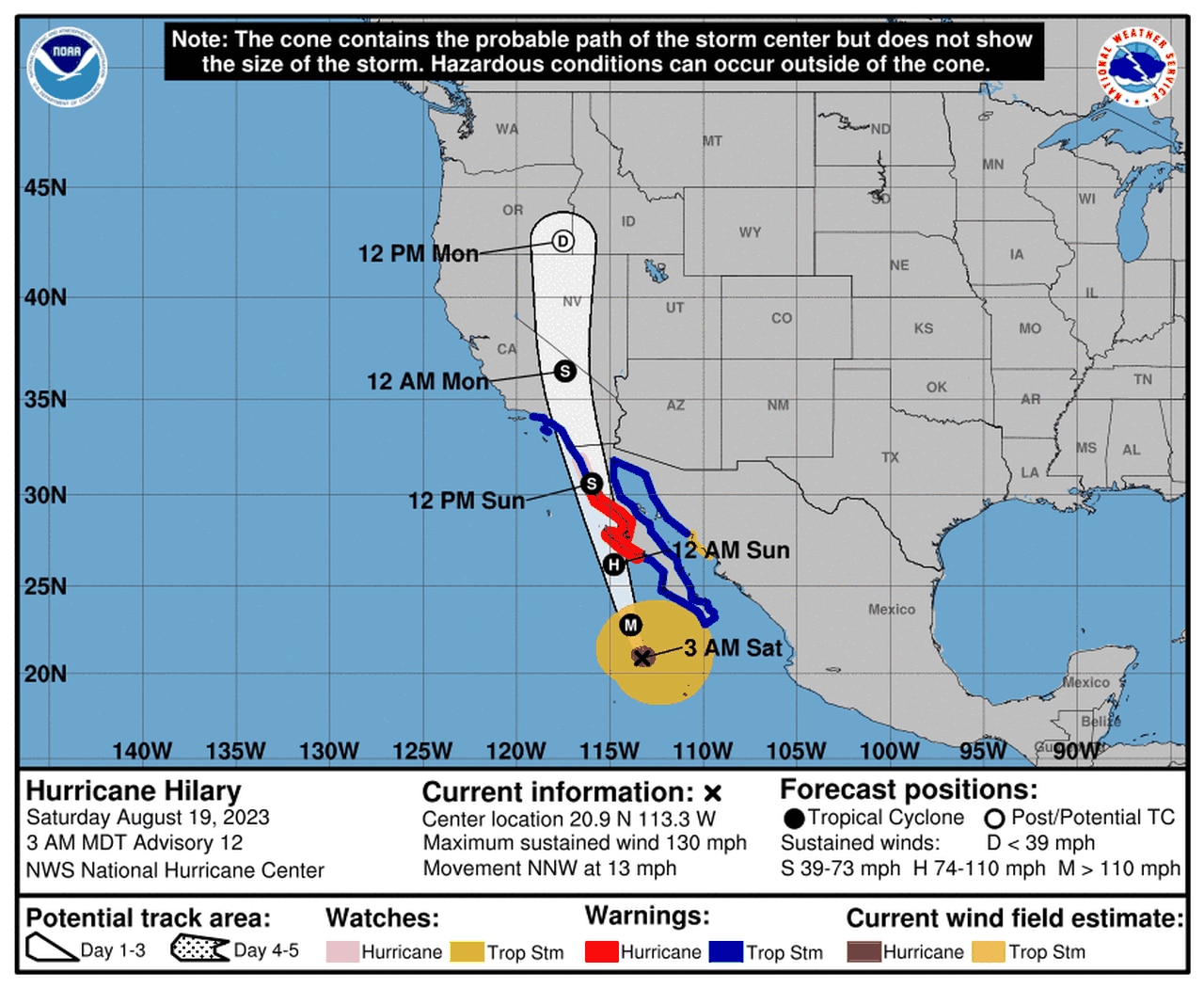
The hurricane center was also tracking Hurricane Hilary in the eastern Pacific. Hilary is a rare storm on a path that will bring it near southern California, and forecasters warn that catastrophic flooding will be possible starting this weekend.
Hilary also has prompted the first tropical storm warnings on record for California. Here’s the forecast path for Hilary:
Hilary was a Category 4 hurricane early Saturday and is expected to bring widespread flooding to parts of the Southwest U.S. over the weekend.
But of more concern to those along the Gulf Coast was the system expected to move into the Gulf in a few days.
The disturbance on Saturday morning was located near the Bahamas. It’s expected to stay on a path westward and move into the Gulf early next week. An area of low pressure is expected to form thereafter.
The disturbance is expected to stay on a westward path that would make it more of a concern for Texas than the northern Gulf Coast.
The hurricane center was also watching three other areas for potential development.
The first one was in the eastern Atlantic a few hundred miles west of the Cabo Verde Islands. It continued to look more organized early Saturday morning, and the hurricane center said a short-lived tropical depression is “likely” to form over the weekend as the system moves to the west-northwest or northwest.
It’s not expected to affect land, and the hurricane center said upper-level winds will turn more hostile and limit any more development by early next week.
Another wave was in the central tropical Atlantic about halfway between the Cabo Verde Islands and the Caribbean. Forecasters have dropped the odds of it becoming a tropical depression to 30 percent and said it will move into unfavorable conditions over the next day or two.
The last system being monitored was east-southeast of the Lesser Antilles early Saturday.
The hurricane center said it was disorganized as of Saturday morning but could gradually develop in next week as it tracks to the west-northwest across the Lesser Antilles and into the Caribbean.
It has a 30 percent probability of becoming a tropical depression in the next week.
The next three names on the Atlantic storm list, by the way, are Emily, Franklin and Gert.
The Atlantic has been quiet lately but had a busy start to the season. So far there have been three tropical storms, an unnamed storm and one hurricane (Don).
The peak of the Atlantic hurricane season is just around the corner on Sept. 10. The last day of the season will be Nov. 30.