Arctic blast headed for Alabama
A early dose of winter is on its way to Alabama.
A cold front will move through today (Monday) and bring a blast of arctic air that will affect the whole state starting tonight.
Low temperatures will drop to or below freezing in some areas, and freeze warnings and watches have been issued for much of the state by the National Weather Service.
Look for lows to drop to 32 degrees or lower in north Alabama tonight. Those chilly readings could expand southward to central and even parts of south Alabama on Tuesday night and Wednesday night as well, according to forecasters.
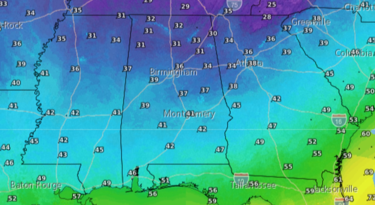
Here are tonight’s forecast low temperatures:
Tonight will be much colder for much of Alabama. Here are the lows expected overnight tonight.
High temperatures on Tuesday will be downright chilly compared with temperatures over the weekend. Here are the forecast highs for Tuesday:
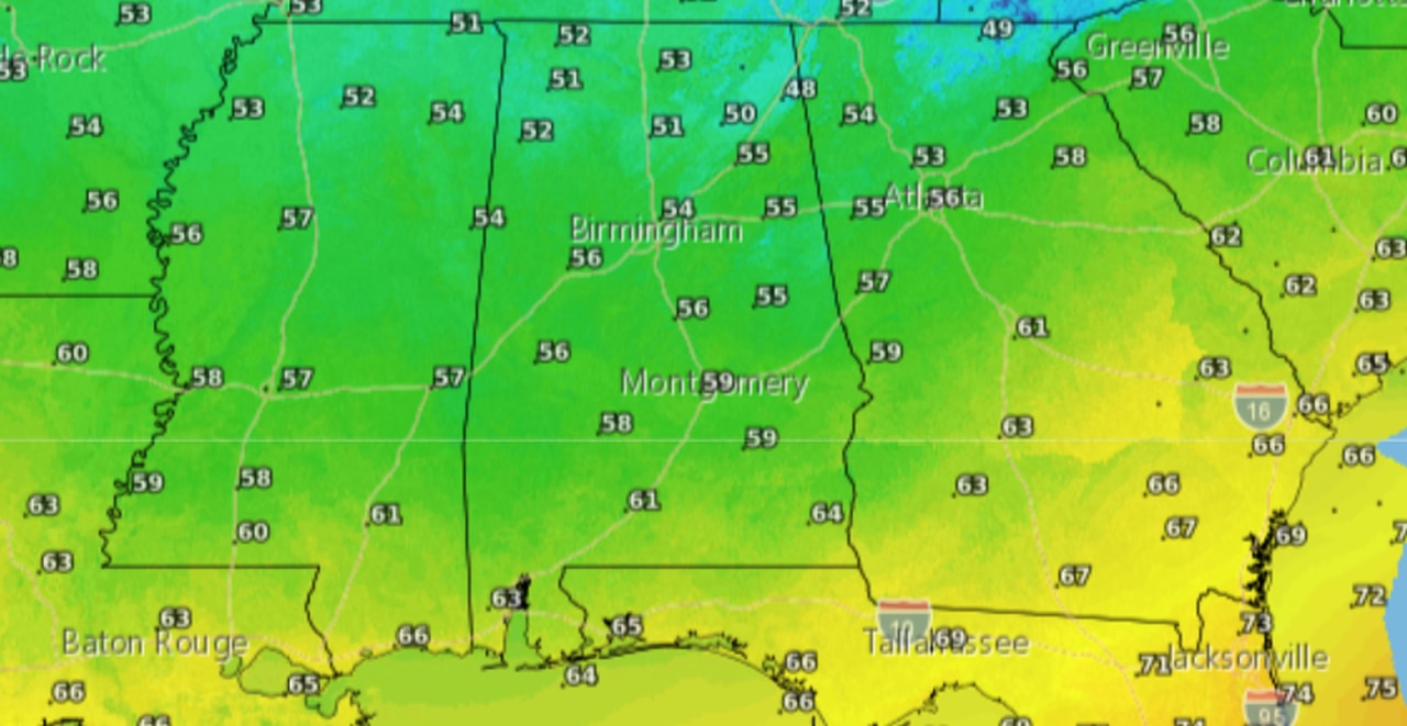
Some parts of Alabama may not make it out of the 50s on Tuesday.
Then it will get even colder on Tuesday night into Wednesday morning. Here are the forecast lows for Tuesday night:
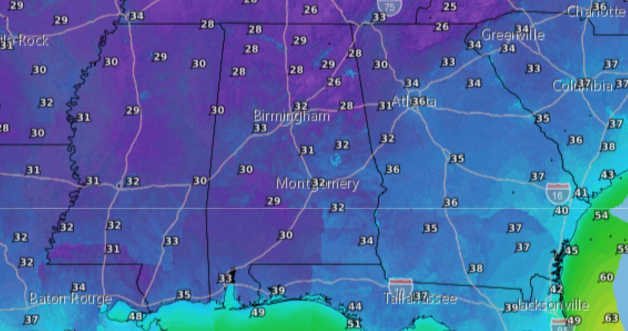
Get ready for freezing temperatures on Tuesday night into Wednesday morning.
Wednesday night into Thursday morning will be just as cold (and maybe even colder in some areas):
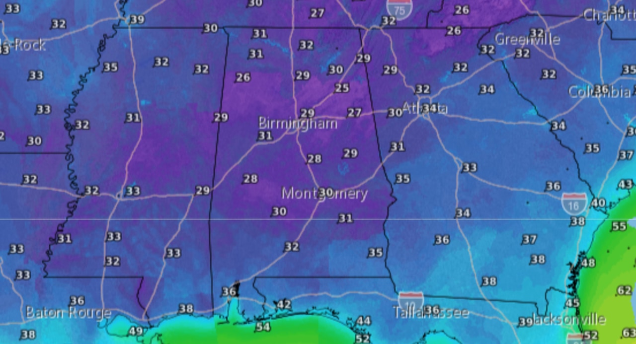
Here are the lows expected Wednesday night into Thursday morning.
Here’s a look at the freeze warnings and watches for Alabama:
NORTH ALABAMA
* Freeze warning: A freeze warning will be in effect for all of north Alabama from 1 a.m. until 9 a.m. Tuesday.
The counties affected are Lauderdale, Colbert, Franklin, Lawrence, Limestone, Madison, Morgan, Marshall, Jackson, DeKalb and Cullman.
The National Weather Service in Huntsville said temperatures as low as 31 degrees area expected across the region.
CENTRAL ALABAMA
* Freeze warning: A freeze warning will be in effect for Marion, Winston, Blount, Etowah and Cherokee counties from 2 a.m. until 9 a.m. Tuesday.
A freeze watch will also be in effect for those same counties from Tuesday night into Wednesday morning.
* Freeze watch: For much of central Alabama from Tuesday night into Wednesday morning.
The counties in the watch are Lamar, Fayette, Walker, Calhoun, Cleburne, Pickens, Tuscaloosa, Jefferson, Shelby, St. Clair, Talladega, Clay, Randolph, Sumter, Greene, Hale, Perry, Bibb, Chilton, Coosa, Tallapoosa, Chambers, Marengo, Dallas, Autauga, Lowndes, Elmore, Montgomery, Macon, Bullock, Lee, Russell, Pike and Barbour.
SOUTH ALABAMA
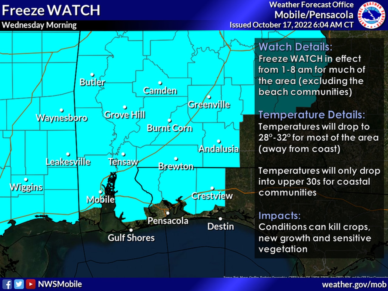
A freeze watch will be in effect for part of south Alabama starting on Tuesday night.
* Freeze watch: A freeze watch has been issued for Choctaw, Washington, Clarke, Wilcox, Monroe, Conecuh, Butler, Crenshaw, Escambia, Covington and inland Mobile and Baldwin counties from Tuesday night into Wednesday morning.
The National Weather Service in Mobile said temperatures as low as 29 degrees will be possible Tuesday night into Wednesday morning in those counties.
RECORD COLD?
Could there be some record cold temps? It’s possible. Here is a look at the record lows for some Alabama cities for the next three days:
BIRMINGHAM
Oct. 18: 31 in 1948
Oct. 19: 29 in 1948
Oct. 20: 32 in 1964
DAUPHIN ISLAND
Oct. 18: 49 in 2009
Oct. 19: 46 in 2009
Oct. 20: 42 in 1989
DOTHAN
Oct. 18: 36 in 2001
Oct. 19: 37 in 2009
Oct. 20: 34 in 1989
FORT PAYNE
Oct. 18: 32 in 2009
Oct. 19: 38 in 2015
Oct. 20: 39 in 2008
HIGHLAND HOME
Oct. 18: 43 in 2015
Oct. 19: 42 in 2015
Oct. 20: 42 in 2015
HUNTSVILLE
Oct. 18: 28 in 1943
Oct. 19: 25 in 1948
Oct. 20: 30 in 1925
MOBILE
Oct. 18: 35 in 1948
Oct. 19: 38 in 1989
Oct. 20: 33 in 1989
MONTGOMERY
Oct. 18: 35 in 2001
Oct. 19: 34 in 1948
Oct. 20: 32 in 1989
MUSCLE SHOALS
Oct. 18: 29 in 1948
Oct. 19: 28 in 1948
Oct. 20: 28 in 1917
SELMA
Oct. 18: 34 in 1943
Oct. 19: 34 in 1948
Oct. 20: 35 in 1989
TROY
Oct. 18: 31 in 1943
Oct. 19: 37 in 1981
Oct. 20: 32 in 1989
TUSCALOOSA
Oct. 18: 30 in 1948
Oct. 19: 28 in 1948
Oct. 20: 32 in 1989