Alabama sees 4 inches of snow in areas with more winter weather on the way: What to expect
Snow and wintry precipitation continued to fall on parts of north Alabama on Monday morning, and it could spread southward and affect more of the state later today and tonight.
Winter storm warnings were in effect for north Alabama, which was expected to see the most wintry precipitation, and winter weather advisories will go into effect through the day in parts of central and even south Alabama.
Areas in north Alabama could get a total of 1 to 6 inches of snow, sleet and ice. Areas to the south may get less snow but enough ice to cause travel headaches.
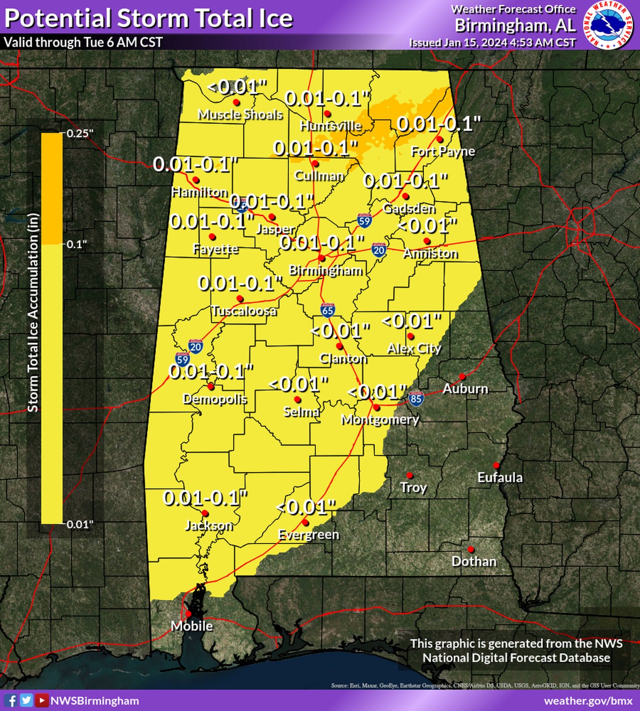
The forecast for additional snow (not counting what has already fallen) is at the top of this post. Below is the forecast for ice:
Ice will be possible across a large part of Alabama through Tuesday.NWS
The National Weather Service has gotten reports of accumulating snow in areas around north Alabama, and also reports of roads becoming icy and hazardous for travel.
Some of the higher snow reports so far are from Lauderdale County: 4 inches in Waterloo, 3.8 inches near Underwood, 3.75 in Cloverdale in and 2 inches in Florence.
More wintry precipitation was ongoing across parts of north Alabama early Monday:
Temperatures will be falling across the state today and will be especially cold tonight — which could cause icy spots on roads and make travel dangerous.
A hard freeze warning has been issued for north and parts of central Alabama tonight.
It will be even colder Tuesday night, with temperatures in the single digits and teens possible over a large part of Alabama. More hard freeze warnings and wind chill warnings will go into effect then for more of Alabama.
Here’s the low temperature forecast for tonight into Tuesday morning:
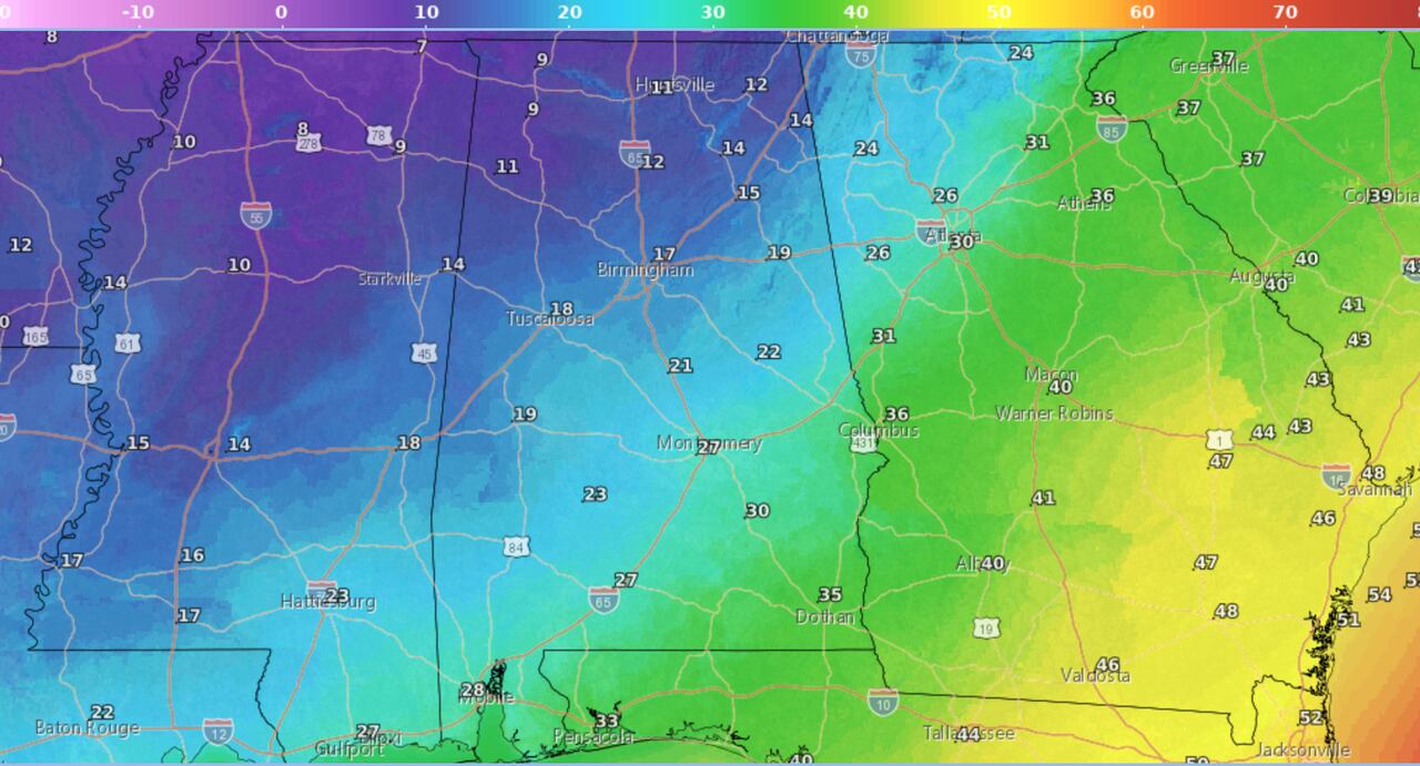
Here are the lows expected tonight into Tuesday morning.NWS
Here are Tuesday’s expected high temperatures:
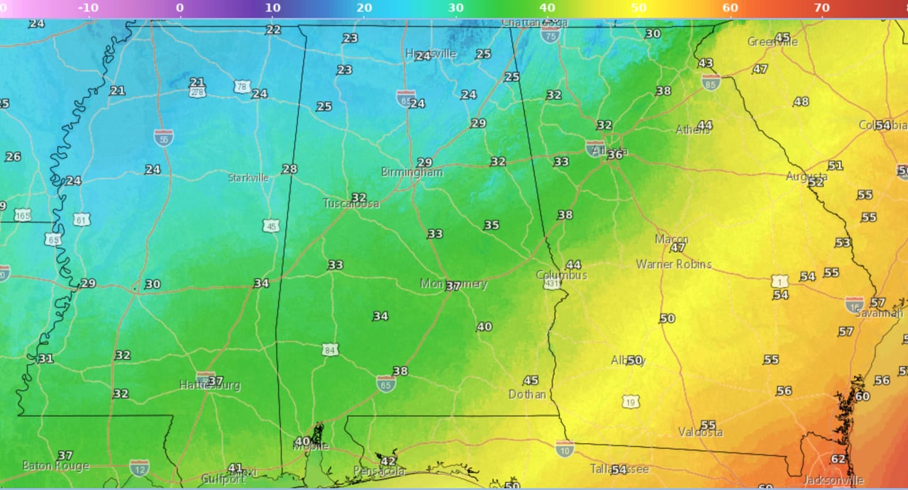
Here are Tuesday’s forecast high temperatures.NWS
Here are the forecast low temperatures for Tuesday night into Wednesday morning, which could be the coldest one of this event:
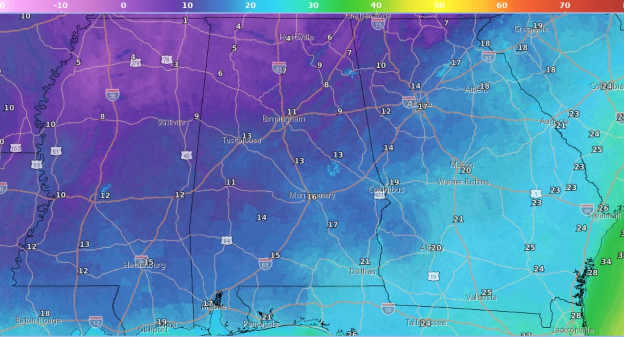
Tuesday night into Wednesday morning could be the coldest for most of the state.NWS
Here is a look at what the National Weather Service offices across the state were thinking on Monday.
NORTH ALABAMA
* A winter storm warning is in effect for all of north Alabama until 6 a.m. Tuesday.
The National Weather Service in Huntsville said heavy mixed precipitation is expected with up to an additional 4 inches of snow and a tenth of an inch of ice.
The north Alabama counties in the winter storm warning are Lauderdale, Colbert, Franklin, Lawrence, Limestone, Madison, Morgan, Marshall, Jackson, DeKalb and Cullman.
* Hard freeze warning for all of north Alabama from 8 p.m. Monday until 10 a.m. Wednesday. Temperatures are forecast to drop into the teens tonight and will remain below freezing in many areas all day on Tuesday. Temperatures are forecast to drop into the single digits and teens Tuesday night.
CENTRAL ALABAMA
Here’s when frozen precipitation could affect central Alabama.NWS
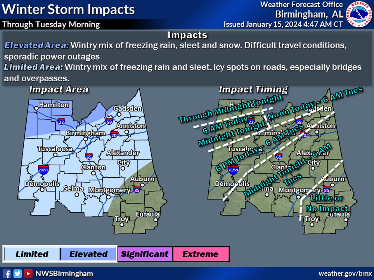
The National Weather Service in Birmingham said wintry precipitation was already affecting far northwest portions of central Alabama on Monday morning. Forecasters added that the arctic front is east of the area, and the wintry mix is expected to expand southeastward today into tonight. Bitter cold is expected through the middle of the week with another surge of cold air possible this weekend.
A winter weather advisory has been extended slightly south and east as of Monday morning.
* Winter storm warning until midnight tonight for Marion and Winston counties. The National Weather Service in Birmingham said a wintry mix of snow, freezing rain and sleet is expected. Total snow and sleet accumulations of up to 1.5 inches and ice accumulations of around one tenth of an inch are expected.
* Winter weather advisory until midnight tonight for Lamar, Fayette and Walker counties. A wintry mix of sleet and freezing rain is expected. Total sleet accumulations less than half an inch and ice accumulations of up to one tenth of an inch will be possible. Wind chills below zero late tonight and tomorrow morning.
* Winter weather advisory from noon today until 6 a.m. Tuesday for Blount, Etowah, Pickens and Sumter counties. A wintry mix of sleet and freezing rain is expected, with total sleet accumulations less than a quarter inch and ice accumulations of up to one tenth of an inch
* Winter weather advisory from 6 p.m. today until 6 a.m. Tuesday for Calhoun, Cherokee, Cleburne, Tuscaloosa, Jefferson, Shelby, St. Clair, Talladega, Hale, Perry, Bibb, Chilton, Marengo, Greene and Dallas counties. Freezing rain is expected. Total ice accumulations of a light glaze.
* Winter weather advisory from midnight tonight until 6 a.m. Tuesday for Clay, Randolph, Coosa, Tallapoosa, Autauga, Lowndes, Elmore and Montgomery counties. A light glaze of freezing rain is expected.
SOUTH ALABAMA
A winter weather advisory will be in effect for part of southwest Alabama.NWS
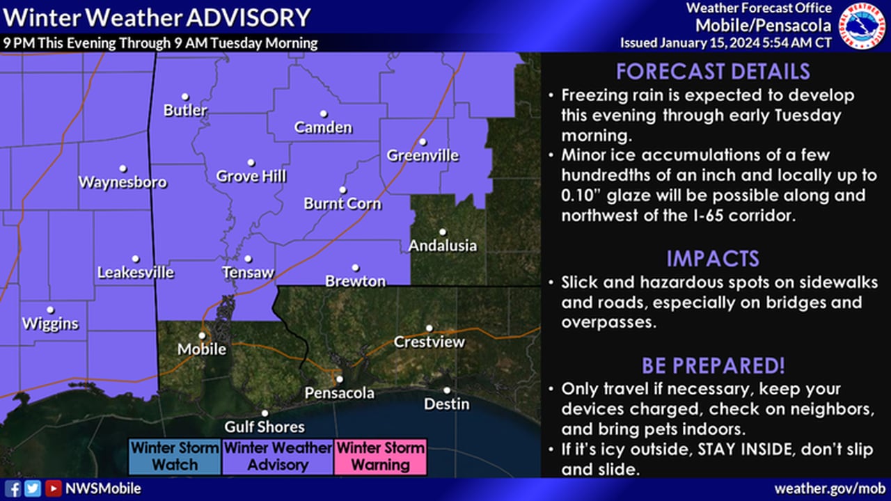
* Winter weather advisory from 9 p.m. Monday until 9 a.m. Tuesday for Choctaw, Washington, Clarke, Wilcox, Monroe, Conecuh, Butler, Crenshaw, Escambia and the inland parts of Mobile and Baldwin counties.
A light glaze of freezing rain is expected.
* Wind chill advisory from 9 a.m. Tuesday until 9 a.m. Wednesday for the same area above. Wind chills as low as zero to 5 above zero will be possible.