Alabama âSnowmaggedonâ 10 years later: How it happened and what we learned
It’s hard to believe it’s been 10 years since Alabama’s infamous “Snowmaggedon.”
It’s also frequently called the “Snowpocalypse” — and there are other variations.
“It has a couple of names, and two of them we can repeat,” said John De Block of the National Weather Service in Birmingham.
It was Jan. 28, 2014, a Tuesday, when parts of Alabama were first paralyzed by a round of winter precipitation that turned roadways and interstates into ice rinks, stranding many in their cars in freezing temperatures. Winter conditions caused travel nightmares for three days after that as well.
According to the weather service, Alabama State Troopers responded to 731 vehicle accidents across the state over four days (Jan. 28-31).
Snow and sleet caused headaches from central Alabama all the way into south Alabama, where sleet fell on Mobile’s Bayway and icy slush was spotted on the Bay.
The icy roads were linked to nine deaths from vehicle accidents, according to the weather service.
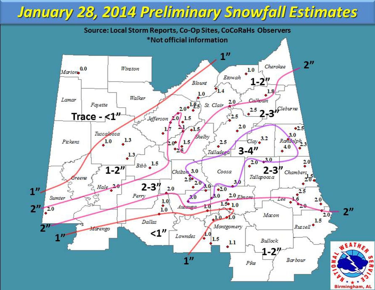
According to the weather service snowfall totals across central Alabama ranged from zero in the far northwest to 2-3 inches in a corridor from Chilton County northeast to Randolph County.
Three inches of snow was also reported in south Alabama’s Butler County and multiple south Alabama communities were covered in sleet.
Some counties in the southeast half of the state also reported up to 0.25 inches of ice.
The National Weather Service in Mobile reported 1.3 inches of sleet at its office, and ice and slush was reported on many local waterways, including Mobile Bay. Interstate 10 was shut down due to icing.
It wasn’t a lot of snow that fell on central Alabama, but it paralyzed much of the region.NWS files
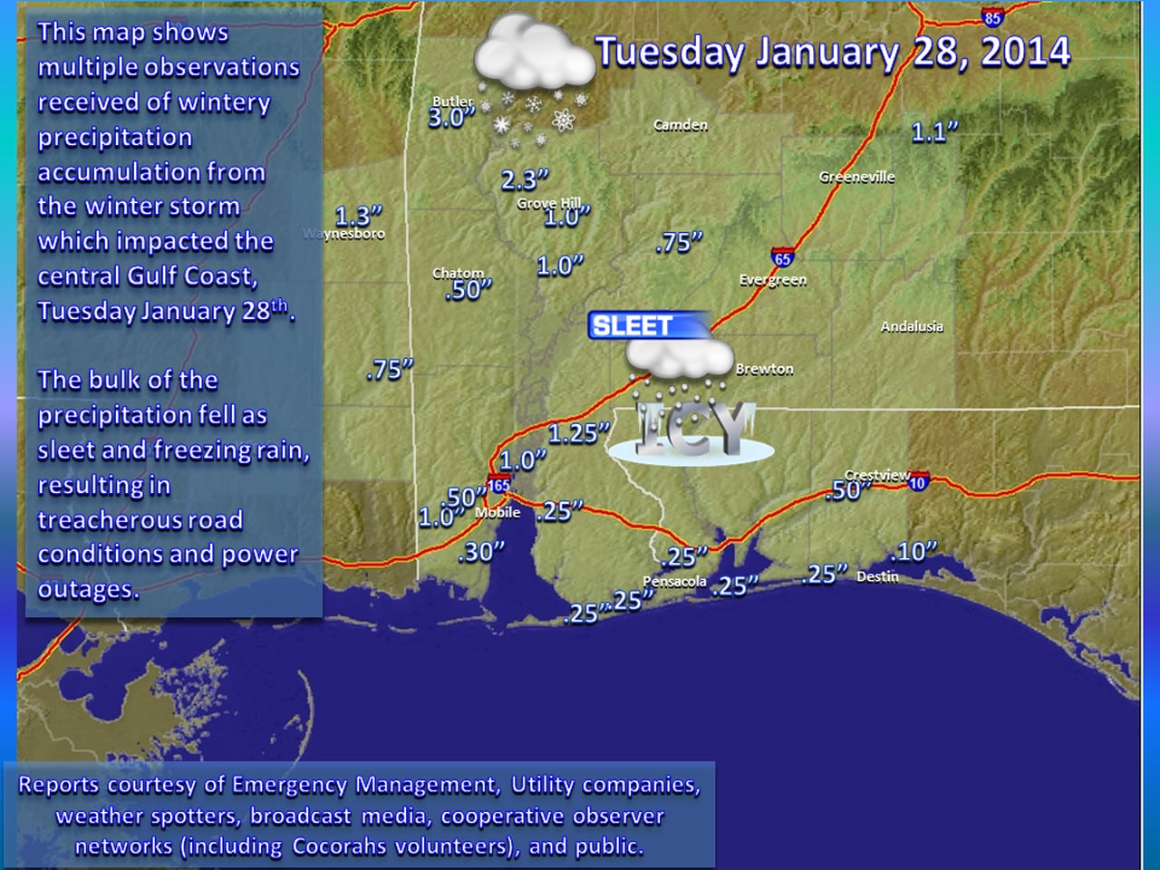
Here’s a look at the precipitation that fell across south Alabama starting on Jan. 28, 2014.NWS files
Alabama learned a lot about snow — and ice— that day.
“If I were to tell you we were going to have an inch of snow in Alabama prior to this event, I don’t think anyone would really cringe or go into a panic. It’s an inch of snow, no big deal, it’s going to be OK,” De Block said.
“When we get snow here, the majority of the time the temperature is in the upper 20s and it warms up the next day into the 30s and we get to make snowmen and have a few snowball fights and everything. It’s fun for 12-15 hours and then it’s melted and gone.”
NO ORDINARY SNOW EVENT
But this was no ordinary snow event — even by Alabama standards.
First off, it was very warm (for January) just a few days before. According to the weather service, temperatures in parts of Alabama were in the 60s just two days before Snowmaggedon.
That’s hardly snow weather. But on the horizon was an arctic front, and it had very, very cold air right behind it. Straight from the North Pole, De Block said.
The arctic front passed through Alabama, and temperatures in many areas dropped into the 20s.
The arctic air was very cold and very, very dry. The weather service said some dew points actually registered in the negative numbers — not something you see in Alabama every day.
“The cold air just wrings the moisture out of the air,” De Block said.
It also caused an extra headache — in a day of headaches — for forecasters. The weather service said the drier air made it very challenging to forecast exactly when there would be enough moisture in the air to generate any snow. Another challenge was knowing how far north the precipitation would fall.
This was an occasion when north Alabama actually wasn’t in the bullseye for snow — in this case the heavier precipitation was expected over south-central and even south Alabama, which were under winter storm warnings.
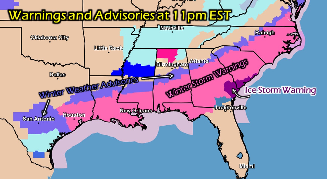
South Alabama was under winter storm warnings during the ice and snow storm of 2014. Those warnings were issued while it was still 60 degrees outside.NWS
“So we had these warm temperatures. And we were off by maybe a county in the location of where we thought the maximum amount of snow was going to fall, and as a result we wound up getting more snow into the Birmingham area than we were expecting. And our timing was a little bit off as well,” De Block said.
“But the biggest factor was that when the snow fell, it fell on warm roads. And the air temperatures were very cold. So when the snow melted, it quickly froze over and we got this flash freeze of melted snow on roadways. And once the traffic got jammed up, there was no recovery from that.
“All the cards lined up in the favor of a Snowpocalyse or Snowmaggedon.”
HOW IT HAPPENED
Meteorologically, there was a stark contrast going from above-average temperatures to very cold arctic air over a short period of time. Moist air from the Gulf of Mexico worked its way northward and flowed over the top of the shallower arctic air. Rain falling through that very cold air actually has a cooling effect.
“It’s a cooling process, almost like an engine; it was feeding on itself. It got colder, so the snow was more efficient,” De Block said.
“We had lots of moisture in what we call the ‘snow growth zone’ high up in the atmosphere where it’s between minus-10 and minus-20 degrees Celsius, so we had ample snow growth happening. High pressure centered to the north with a northeasterly flow just kept bringing reinforcing the cold air at the lower levels, as this warm, moist air rides up over the top of it. That’s typically when we have our big snow events in a classical sense in Alabama in that pattern. It was an extreme version of that setup with that cold Arctic air to the north.”
There were a number of lessons learned in January 2014.
One of the biggest was that it only takes a small amount of snow to cause big, big trouble.
“Even through it wasn’t a huge amount of snow it had a huge impact. A lesson that we learned from Jan. 28, 2014, is snow amount is not equal to snow impact,” De Block said.
As a result the Alabama Department of Transportation, the Alabama Emergency Management Agency, the National Weather Service and national insurance carriers have teamed up as part of a federal project called Pathfinder, De Block said.
De Block said that the project provides a framework for state transportation departments, the National Weather Service and private weather firms that forecast road temperatures to work together to try to get consistent messaging about the potential impacts from a weather event.
“For this Pathfinder project ALDOT contracted with Baron Weather, and Baron is the contractor that provides the expertise in regard to road temperatures and road behavior with precipitation,” De Block said.
“So we combine their expertise of forecasting road conditions with the expertise of the National Weather Service of forecasting what falls from the sky and then the DOT experts know what their resources are and what they have available to go treat the roads.”
One of the lasting effects of Snowmaggedon is that many Alabamians are less resistant to heeding official advice on potential winter precipitation.
“We’ve learned a lot, both the weather service and the department of transportation and EMA and the population has learned as well that we don’t want to mess with these kind of systems,” De Block said.
That came into play again last week when north Alabama was hit hard with icy roads and snow from the last arctic front that moved through.
“So the message is to remember the lessons that we’ve learned, listen for messaging from the National Weather Service and ALDOT … and play it on the safe side. Don’t take unnecessary risks when it comes to winter weather,” De Block said.
“It’s a hard decision to make because a lot of peoples’ incomes depend on getting to work. We hate to impact someone’s livelihood, but it’s better to be alive and maybe have to work a couple extra hours later in the week than be stranded, injured or worse.”