âSignificantâ weather event possible next week, Alabama EMA says; Times and places to know
Alabama is in for a rainy weekend followed by chances for what emergency management officials are describing as a potentially “significant” weather event early next week.
Rain and a few thunderstorms will enter the western section of the state Friday afternoon into evening, spreading across the rest of Alabama tonight before ending Saturday morning, according to Jim Stefkovich, meteorologist with the Alabama Emergency Management Agency.
Most of the instability will remain offshore but Baldwin, Mobile and possibly counties along the Alabama/Florida state line could see a couple of severe storms between 5 p.m. Friday and 2 a.m. Saturday. The main threat would be damaging wind gusts or tornadoes with rainfall up to 2 inches in areas south of Highway 80/I-85.
Non-thunderstorm winds will be increasing statewide Friday and continuing through early Saturday morning with sustained winds of up to 20 mph and gusts of up to 30 mph.
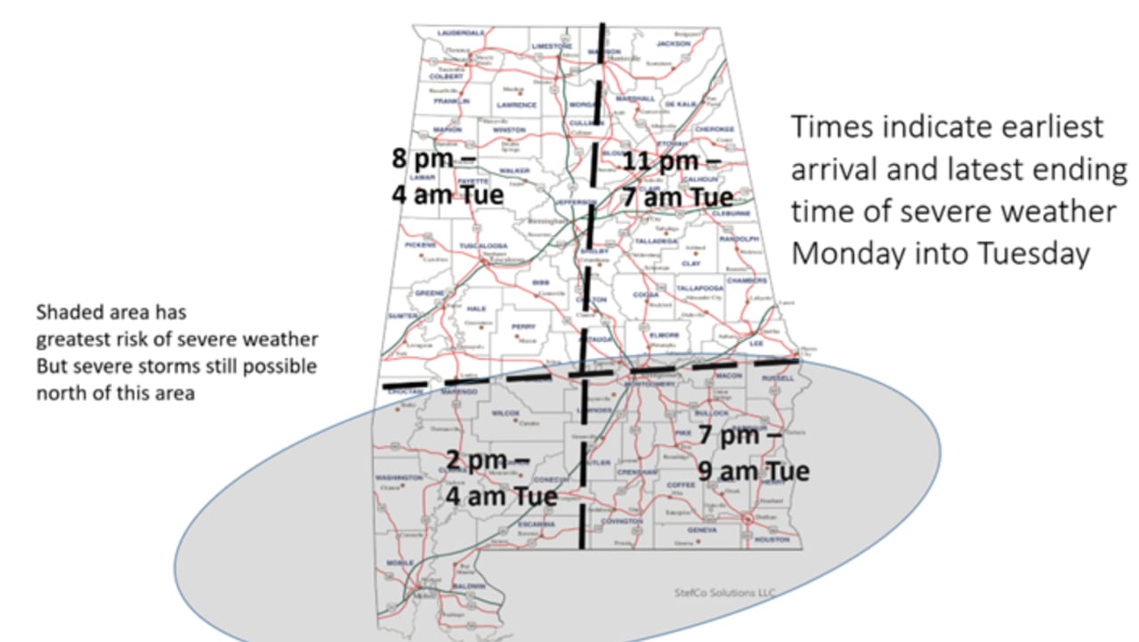
Monday into Tuesday
The weather situation will intensify Monday into Tuesday when a potent system likely produces supercells that could begin south of Livington/Montgomery/Auburn line beginning Monday afternoon and continuing into the evening. Damaging wind gusts and tornadoes will be possible, including EF3 or greater, Stefkovich said.
The southern third of the state can expect to see storms entering from the west around 2 p.m. Monday as they track towards the east until about 4 a.m. The southeastern part of the state will see storms starting around 7 p.m. Monday until 9 a.m. Tuesday.
Storms are also possible in the central and northern parts of the state from around 8 p.m. Monday to 4 a.m. Tuesday for the western part of the state to 11 p.m. Monday – 7 a.m. Tuesday for the eastern half.
Those storms will be followed by another fast-moving line that will enter the western portion of the state Monday evening and exiting the eastern portions Tuesday morning. Damaging wind gusts, along with a few embedded tornadoes, will be possible from central Alabama to the coast.
Non-thunderstorm winds both ahead of and behind this system will produce gusts from 25-40 mph – enough to topple trees and cause power outages- from Monday afternoon through Tuesday afternoon. Widespread rain of up to 4 inches is possible with localized flash flooding a concern, especially for areas south of Highway 80/I-85.
Precipitation will end across most of the state early Tuesday afternoon though showers could continue north of I-20 into early Wednesday morning with a changeover to snow flurries or light snow possible in far northern Alabama Tuesday evening. No impacts are expected from the snowfall.