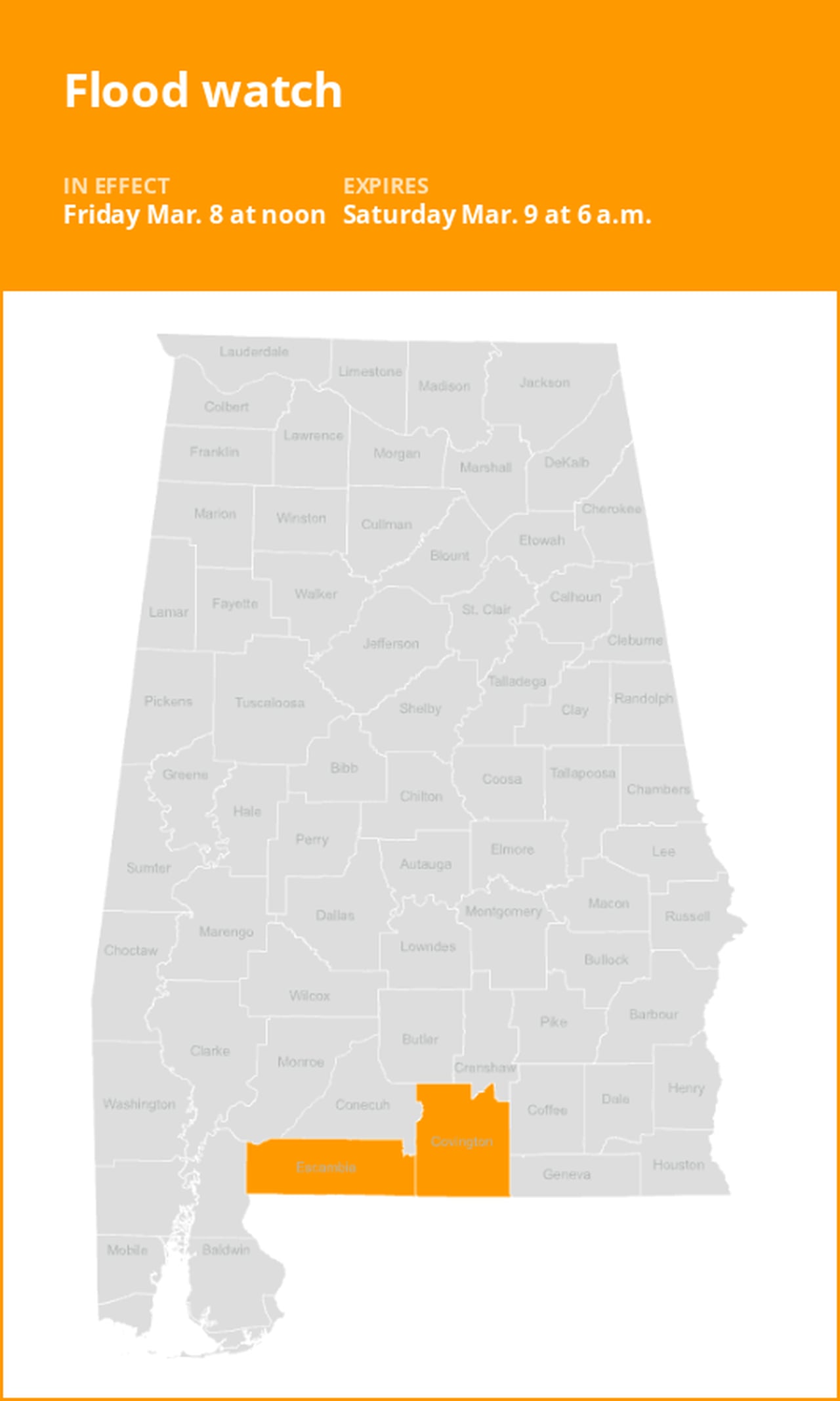
Update: Flood watch issued for South Alabama until Saturday morning
On Friday at 9:18 a.m. an updated flood watch was issued by the National Weather Service valid from noon until Saturday 6 a.m. for Choctaw, Washington, Clarke, Wilcox, Monroe, Conecuh, Butler, Crenshaw, Escambia and Covington counties.
The weather service states, “Flooding caused by excessive rainfall continues to be possible.”
“Excessive runoff may result in flooding of rivers, creeks, streams, and other low-lying and flood-prone locations,” comments the weather service. “You should monitor later forecasts and be alert for possible Flood Warnings. Those living in areas prone to flooding should be prepared to take action should flooding develop.”
Breaking down weather alerts: advisories, watches, and warnings
- Flash flood warning: Take action!
A flash flood warning is issued when a flash flood is imminent or occurring. If you are in a flood-prone area, move immediately to high ground. A flash flood is a sudden violent flood that can take from minutes to hours to develop. It is even possible to experience a flash flood in areas not immediately receiving rain.
- Flood warning: Take action!
A flood warning is declared when flooding is on the verge of happening or is already underway.
- Flood advisory: Be aware:
A flood advisory is issued when flooding is not expected to be bad enough to issue a warning. However, it may cause significant inconvenience, and if caution is not exercised, it could lead to situations that may threaten life and/or property.
- Flood watch: Be prepared:
A flood watch is issued when conditions are favorable for flooding. It does not mean flooding will occur, but it is possible.
Weathering the storm: Flood safety guidelines from the weather service
In flood-prone regions or while camping in low-lying areas, understanding and following the weather service flood safety guidelines can be a lifesaver:
1. Move to higher ground:
- If you reside in a flood-prone region or are camping in low-lying terrain, the first step to safety is relocating to higher ground.
2. Follow evacuation orders:
- When local authorities issue an evacuation order, promptly comply. Before leaving, secure your home by locking it.
3. Disconnect utilities and appliances:
- If time allows, disconnect your utilities and appliances. This reduces the risk of electrical hazards during flooding.
4. Steer clear of flooded basements and submerged areas:
- Steer clear of basements or rooms where water has submerged electrical outlets or cords. This helps prevent electrical accidents.
5. Swift evacuation for your safety:
- If you notice sparks or hear buzzing, crackling, snapping, or popping sounds, evacuate without delay. Do not enter water that may carry an electrical charge.
6. Refrain from walking in floodwaters:
- Never attempt to walk through floodwaters. Even just 6 inches of swiftly moving water can forcefully knock you off your feet.
7. Seek higher ground when trapped:
- In the event you become trapped by moving water, make your way to the highest point available and contact emergency services by calling 911.
During periods of intense rainfall, the risk of flooding increases, particularly in low-lying and flood-prone areas. It is imperative to avoid driving through any water on the road, even if it seems shallow. According to the weather service, most cars can be swept away by just 12 inches of rushing water. Stay safe by being prepared and informed.
Rainy roadways ahead: Essential safety tips for heavy rain
When heavy rain strikes, safety is paramount. Equip yourself with these guidelines from the weather service to navigate wet roads and avoid hazards:
Beware of rapid water flow:
- In heavy rain, refrain from parking or walking near culverts or drainage ditches, where swift-moving water can pose a grave danger.
Maintain safe driving distances:
- Use the two-second rule to maintain a safe distance from the car in front of you and allow an extra two seconds in heavy rain.
Reduce speed and drive cautiously:
- On wet roads, slowing down is paramount. Gradually ease off the accelerator and avoid abrupt braking to prevent skidding.
Choose your lane wisely:
- Stick to the middle lanes to minimize the risk of hydroplaning. Outer lanes are more prone to accumulating water.
Prioritize visibility:
- Enhance your visibility in heavy rain by turning on your headlights. Watch out for vehicles in blind spots, as rain-smeared windows can obscure them.
Watch out for slippery roads:
- The initial half-hour of rain is when roads are slickest due to a mixture of rain, grime, and oil. Exercise heightened caution during this period.
Keep a safe distance from large vehicles:
- Large trucks and buses can reduce your visibility with tire spray. Avoid tailgating and pass them swiftly and safely.
Mind your windshield wipers:
- Overloaded wiper blades can hinder visibility. If rain severely limits your sight, pull over and wait for conditions to improve. Seek refuge at rest areas or protected spots.
- If the roadside is your only option, pull off as far as possible, preferably past the end of a guard rail, and wait until the storm passes. Keep your headlights on and turn on emergency flashers to alert other drivers of your position.
By following these safety measures, you can significantly reduce risks and ensure your well-being when heavy rain pours down. Stay informed about weather conditions and heed advice from local authorities to make your journey safe and sound.
Advance Local Weather Alerts is a service provided by United Robots, which uses machine learning to compile the latest data from the National Weather Service.