Expect pea-sized hail with thunderstorms in East Central Alabama Sunday
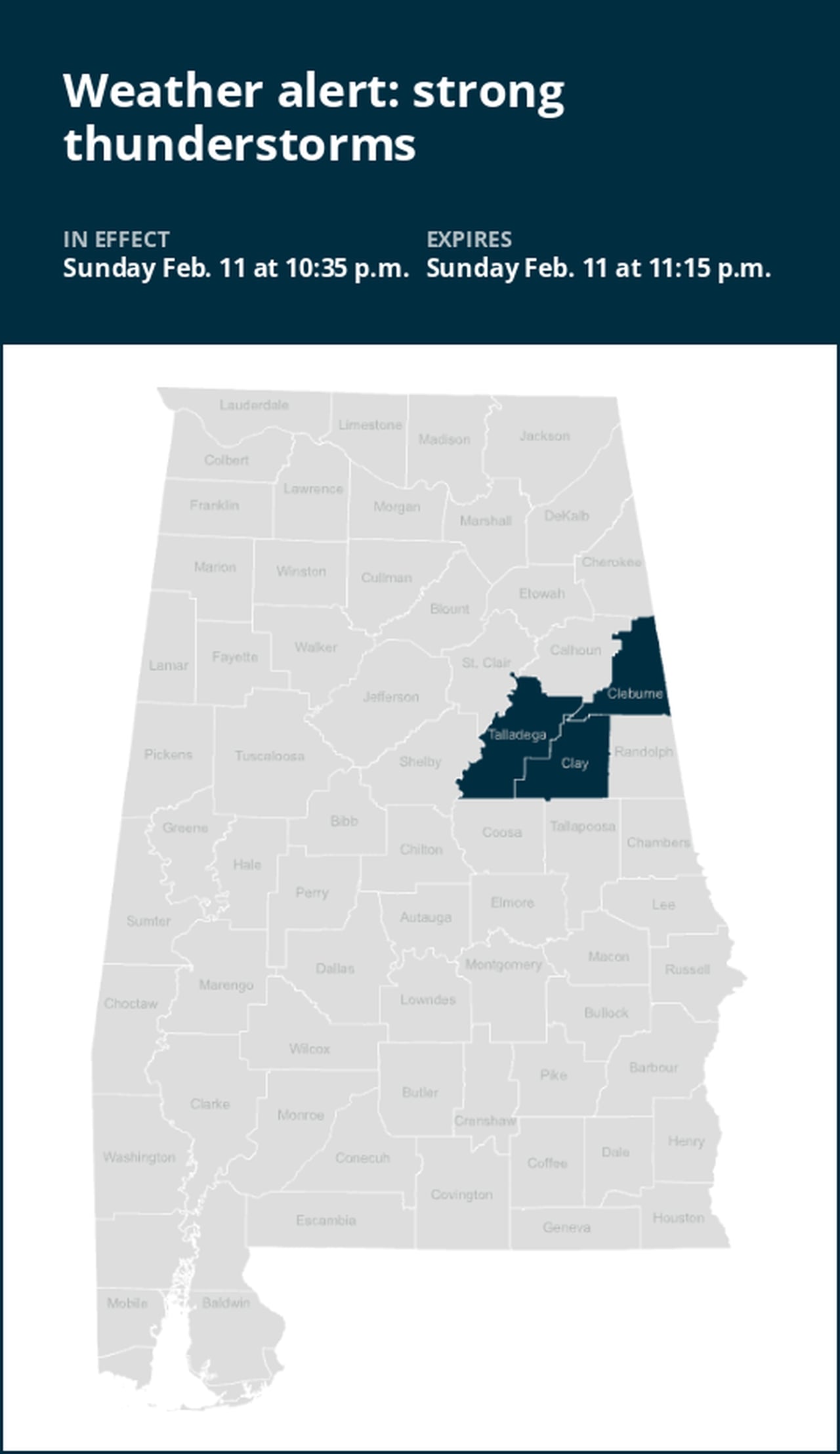
A report from the National Weather Service was issued on Sunday at 10:35 p.m. for strong thunderstorms until 11:15 p.m. for Cleburne, Talladega and Clay counties.
Expect pea-sized hail (0.25 inches) and wind gusts of up to 40 mph.
“At 10:35 p.m., Doppler radar tracked a strong thunderstorm over Waldo, or near Talladega, moving east at 55 mph,” says the weather service. “Gusty winds could knock down tree limbs and blow around unsecured objects. Minor hail damage to vegetation is possible.”
The warning is for Oxford, Talladega, Lineville, Ashland, Munford, Waldo, Grant Town, Barfield, Winterboro, Anniston Regional Airport, Delta, Mount Cheaha, Logan Martin Lake, Hollis Crossroads, Camp Mac, Chandler Springs, Chalafinnee, Ironaton, Jenifer and Lake Chinnabee.
The weather service states, “If outdoors, consider seeking shelter inside a building. Torrential rainfall is also occurring with this storm and may lead to localized flooding. Do not drive your vehicle through flooded roadways.”
When lightning looms: Expert safety tips for thunderstorms
Lightning strikes the United States approximately 25 million times each year, with the bulk of these electrical discharges occurring during the summer months. Tragically, lightning claims the lives of about 20 individuals annually, as reported by the weather service. The risk of lightning-related incidents escalates as thunderstorms draw near, reaching its peak when the storm directly looms overhead. However, it gradually recedes as the tempest moves away.
To guarantee your safety in the midst of a thunderstorm, take into account the following recommendations:
1. Lightning safety plan:
- When venturing outdoors, it’s crucial to have a lightning safety plan in place.
- Stay vigilant by monitoring the sky for ominous signs and listening for the telltale sound of thunder. If thunder is audible, it’s a clear indication of nearby lightning.
- Seek shelter promptly in a safe location, preferably indoors.
2. Indoors safety measures:
- Once you’re indoors, avoid using corded phones, electrical devices, plumbing fixtures, and stay away from windows and doors.
- Lightning can follow conductive pathways, and these precautions reduce the risk of electrical surges.
3. Wait for the all-clear:
- After the last lightning strike or thunderclap, wait at least 30 minutes before resuming outdoor activities.
- Lightning can strike even when a storm has seemingly passed, so exercise caution.
When indoor shelter isn’t available:
If you find yourself outdoors with no access to indoor shelter during a thunderstorm, take these steps to maximize your safety:
- Avoid open fields, hilltops, or ridge crests, as they expose you to greater lightning risk.
- Steer clear of tall, isolated trees and other prominent objects. In forested areas, stay close to lower stands of trees.
- If you’re in a group, ensure that individuals are spaced out to prevent lightning current from transferring between people.
- Camping in an open setting during a thunderstorm is strongly discouraged. If no alternative exists, set up camp in a valley, ravine, or other low-lying areas. Remember that a tent offers no protection against lightning.
- Do not approach water bodies, wet objects, or metal items. While water and metal don’t attract lightning, they conduct electricity effectively and can pose significant risks.
In summary, when facing the threat of lightning, preparedness and vigilance are your best allies. By following these guidelines, you can significantly reduce the likelihood of lightning-related incidents and prioritize your safety.
Navigating rainy roads: Safety tips for wet weather
When heavy rain sets in, the risk of flooding and hazardous driving conditions rises. Whether it’s prolonged rainfall or rapid runoff, being prepared is essential. Here are some valuable safety tips from the weather service to ensure you stay safe in heavy rain:
Beware of swollen waterways:
- Avoid parking or walking in close proximity to culverts or drainage ditches, as the swiftly moving water during heavy rain can potentially carry you away.
Maintain safe driving distances:
- Adhere to the two-second rule for maintaining a safe following distance behind the vehicle in front of you. In heavy rain, allow an additional two seconds of distance to compensate for reduced traction and braking effectiveness.
Reduce speed and drive cautiously:
- If it is raining and the roads are wet, slow down. Take your foot off the accelerator and let your speed drop gradually. Never use the brakes suddenly because this may cause the car to skid.
Choose your lane wisely:
- Stay toward the middle lanes – water tends to pool in the outside lanes.
Prioritize visibility
- Enhance your visibility in heavy rain by activating your headlights. Be particularly vigilant for vehicles in blind spots, as rain-smeared windows can obscure them.
Watch out for slippery roads:
- Be extra careful during the first half hour after rain begins. Grime and oil on the road surface mix with water to make the road slippery.
Keep a safe distance from large vehicles:
- Large trucks and buses can reduce your visibility with tire spray. Avoid tailgating and pass them swiftly and safely.
Mind your windshield wipers:
- Heavy rain can overload the wiper blades. When visibility is so limited that the edges of the road or other vehicles cannot be seen at a safe distance, it is time to pull over and wait for the rain to ease up. It is best to stop at rest areas or other protected areas.
- When stopping by the roadside is your only option, position your vehicle as far off the road as possible, ideally beyond guardrails. Keep your headlights on and activate emergency flashers to alert other drivers of your position.
By following these safety measures, you can significantly reduce risks and ensure your well-being when heavy rain pours down. Stay informed about weather conditions and heed advice from local authorities to make your journey safe and sound.
Advance Local Weather Alerts is a service provided by United Robots, which uses machine learning to compile the latest data from the National Weather Service.