Temperatures take a plunge tonight: How cold will Alabama get?
Icy roadways remained a problem for parts of north Alabama on Friday as another blast of arctic air rolled into the state.
Temperatures will be on a downward trend today, according to the National Weather Service, and lows tonight into Saturday morning will be brutal — in the single digits in north Alabama and the teens and 20s elsewhere. Saturday night into Sunday morning will be just as cold if not colder, according to forecasters.
Wind chill advisories will be in effect starting tonight for parts of the state, as well as hard freeze warnings. Those will continue into Saturday night for some areas.
Saturday will be a bitterly cold day, with highs only reaching the 20s and 30s, and Saturday night into Sunday morning could be even colder, with more single-digit lows possible in north Alabama.
The National Weather Service in Huntsville warned those in north Alabama that ice could continue to be an issue on roads today.
Forecasters issued a special weather statement warning that lingering moisture from recent rainfall and recently melted snow/icepack is expected to freeze as subfreezing temperatures move into the region this morning.
“This will create areas of black ice producing very icy and dangerous conditions on a number of area roadways, including some major highways through noon today,” the weather service said.
“Bridges and overpasses, especially those crossing the Tennessee River, are especially at risk.”
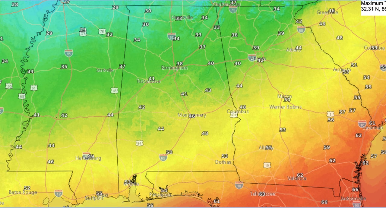
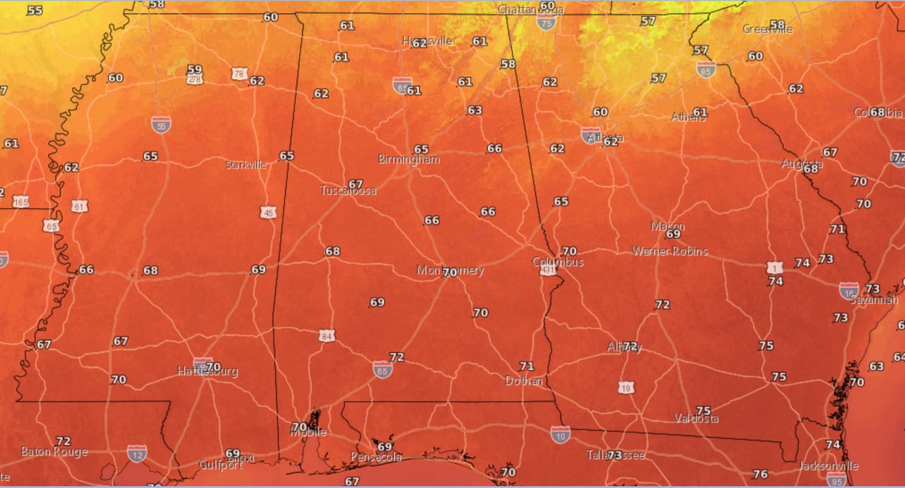
There will be a big spread with highs today across Alabama. North Alabama may not make it above freezing today.
Highs in central Alabama will range from the lower 30s in the north to the upper 40s in the south. And highs in south Alabama are forecast to be in the low 50s.
Here are Friday’s forecast highs:
Here are the forecast highs for Friday.NWS
But temperatures will be falling through the day as another shot of arctic air spreads southward.
Lows tonight will be brutal again, with single digits possible in north Alabama, the teens expected in central Alabama and the low 20s in south Alabama (see tonight’s forecast at the top of this post).
Daytime temperatures across the state on Saturday won’t warm up much. Highs in north Alabama will only make it into the low 20s on Saturday. For central Alabama highs will range from the upper 20s to low 30s in the north to the upper 30s in the south. And south Alabama will have highs only reaching the low 40s.
Here is the high temperature forecast for Saturday:
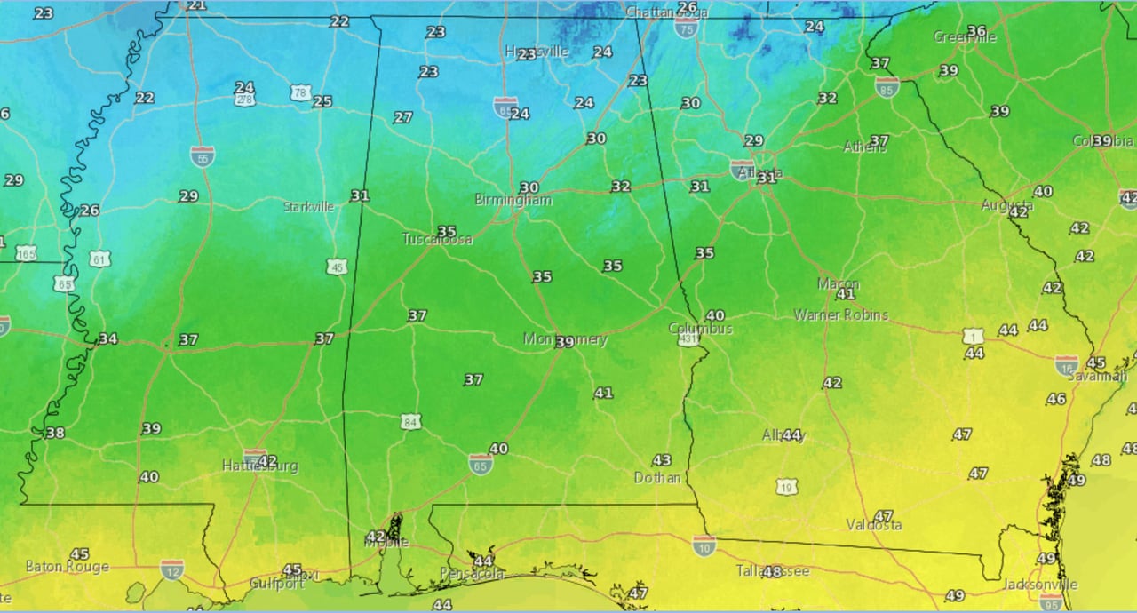
Saturday’s forecast high temperatures.NWS
Saturday night will be just as cold or even colder than Friday night. Lows in north Alabama will be in the single digits. Central Alabama will have lows in the teens and south Alabama will bottom out in the teens or low 20s.
Here are the lows expected from Saturday night into Sunday morning:
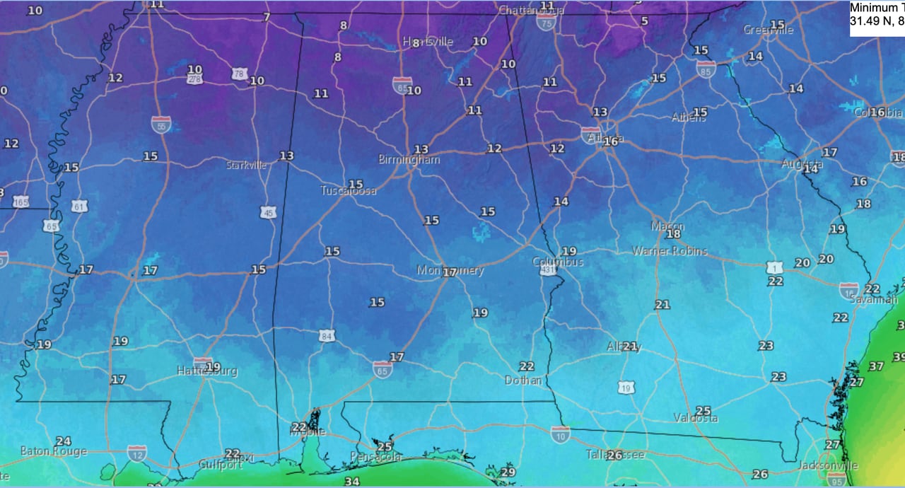
Here are the lows expected from Saturday night into Sunday morning.NWS
But respite from the cold is coming. The weather service says the weather pattern will flip to warm starting on Sunday, with temperatures steadily rising through next week.
Highs on Sunday will range from the 30s in north Alabama to the 40s in south Alabama:
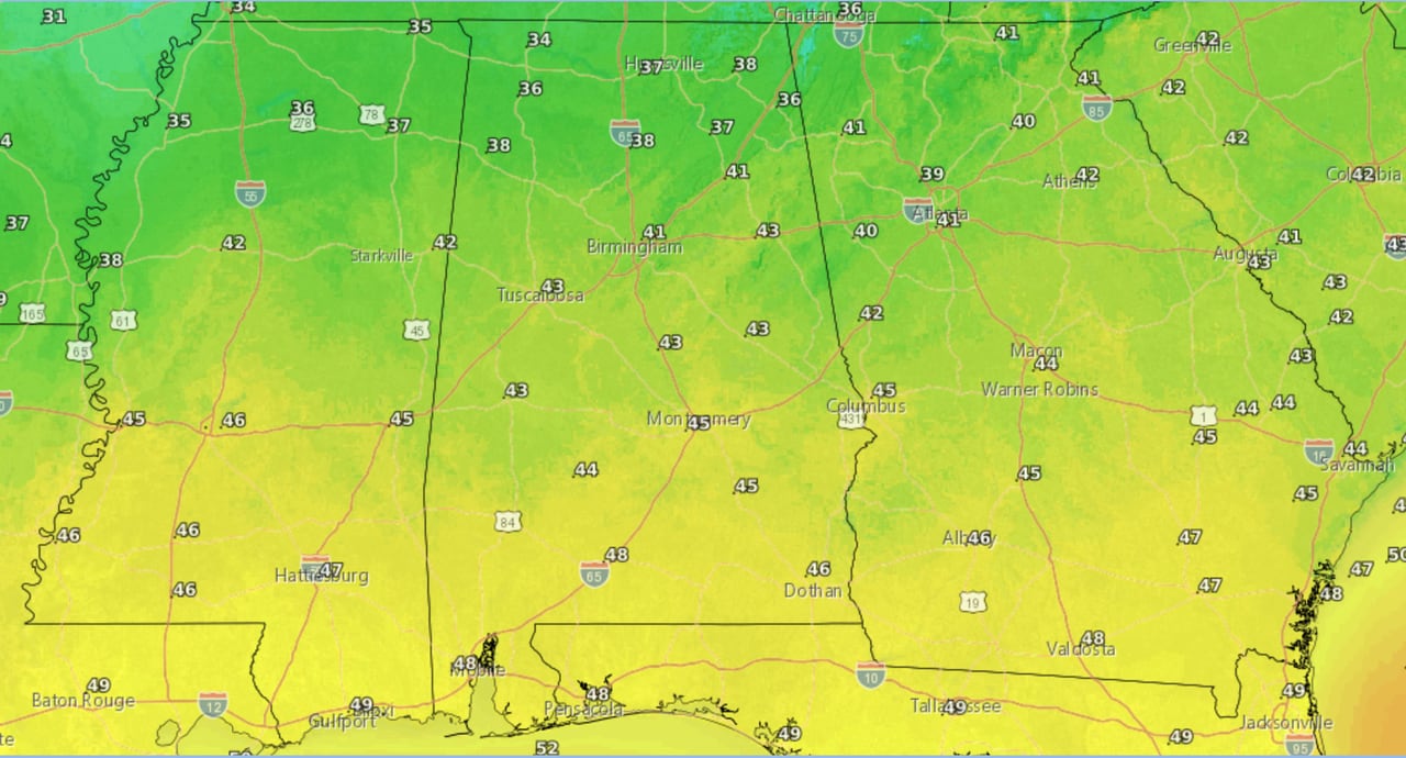
High temperatures for Sunday.NWS
But by Wednesday highs will be in the 60s statewide, and lows will be warmer than today’s highs, in the 40s and 50s.
Here’s a look at what Wednesday could bring for high temperatures:
Warmer weather will reach the entire state by Wednesday.NWS
The warmer weather next week will come with increased rain chances, but so far no severe weather is expected in Alabama.
Here’s a look at what’s expected across Alabama by region:
NORTH ALABAMA
* Wind chill advisory for all of north Alabama from 10 p.m. Friday until noon Saturday. Wind chills as low as 5 to 10 below zero are expected.
CENTRAL ALABAMA
* Wind chill advisory from midnight until 9 a.m. Saturday for Marion, Lamar, Fayette, Winston, Walker, Blount, Etowah, Cherokee, Calhoun, Cleburne and St. Clair counties. Wind chills as low as 5 below zero will be possible.
* Hard freeze warning from 8 p.m. Friday until noon Saturday and from 6 p.m. Saturday until noon Sunday for all of central Alabama. Temperatures as low as single digits possible in some parts of the region both nights.
SOUTH ALABAMA
* Wind chill advisory from midnight tonight until 9 a.m. Saturday for Choctaw, Washington, Clarke, Wilcox, Monroe, Conecuh, Butler, Crenshaw and Covington counties. Wind chills as low as 3 degrees will be possible.
* Wind chill advisory from 9 p.m. CST Friday until 9 a.m. CST Saturday for Coffee, Dale, Geneva, Henry and Houston counties.
* Hard freeze warning from midnight until 9 a.m. Saturday for Choctaw, Washington, Clarke, Wilcox, Monroe, Conecuh, Butler, Crenshaw and Covington counties.
* Hard freeze warning from 2 a.m. Saturday until 9 a.m. for Coffee, Dale, Geneva, Henry and Houston counties.
*Hard freeze warning from 9 p.m. Saturday until 9 a.m. Sunday for Choctaw, Washington, Clarke, Wilcox, Monroe, Conecuh, Butler, Crenshaw, Covington, Escambia and inland and central Mobile and Baldwin counties.