Southeast Alabama under a flash flood warning Tuesday morning
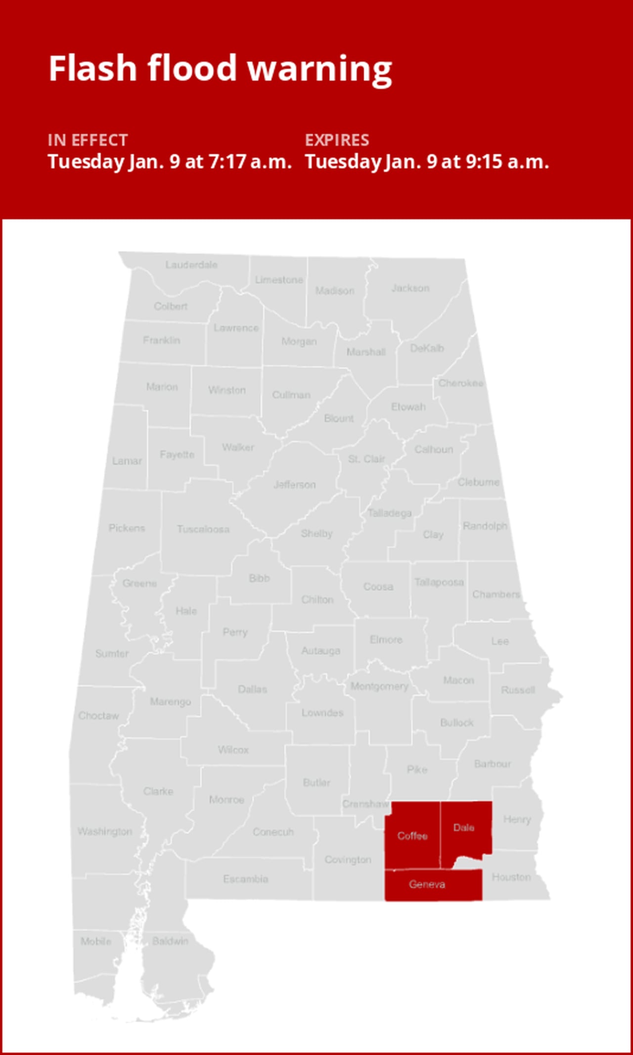
The National Weather Service issued a flash flood warning at 7:17 a.m. on Tuesday in effect until 9:15 a.m. for Coffee, Dale and Geneva counties.
“At 7:17 a.m., Doppler radar indicated thunderstorms producing heavy rain across the warned area. Flash flooding is ongoing or expected to begin shortly,” says the weather service. “Flash flooding of small creeks and streams, urban areas, highways, streets and underpasses as well as other poor drainage and low-lying areas.”
Locations impacted by the warning include Daleville, Elba, Enterprise, Fort Novosel, Ozark, Geneva, Hartford, Level Plains, Samson, Newton, New Brockton, Ariton, Clayhatchee, Kinston, Coffee Springs, Black, Enterprise Municipal A/P, Keyton, Battens Crossroads and Coppinville.
The weather service comments, “Turn around, don’t drown when encountering flooded roads. Most flood deaths occur in vehicles.”
Your guide to weather alerts: Advisories, Watches, and Warnings
- Flash flood warning: Take action!
A flash flood warning is issued when a flash flood is either imminent or already occurring. In flood-prone areas, it’s crucial to move immediately to higher ground. A flash flood is a sudden and violent inundation that can develop within minutes to hours, and it can even happen in areas not currently experiencing rainfall.
- Flood warning: Take action!
A flood warning is issued when flooding is imminent or occurring.
- Flood advisory: Be aware:
A flood advisory is released when flooding is not expected to reach a severity level necessitating a warning. Nonetheless, it can still cause considerable inconvenience and, without exercising caution, potentially lead to situations that threaten life and/or property.
- Flood watch: Be prepared:
A flood watch is issued when conditions are favorable for flooding. It does not mean flooding will occur, but it is possible.
Weather service flood safety guidelines: Weathering the storm
In flood-prone regions or while camping in low-lying areas, understanding and following the weather service flood safety guidelines can be a lifesaver:
1. Move to higher ground:
- If you reside in a flood-prone region or are camping in low-lying terrain, the first step to safety is relocating to higher ground.
2. Adhere to evacuation orders:
- When local authorities issue an evacuation order, promptly comply. Before leaving, secure your home by locking it.
3. Disconnect utilities and appliances:
- If time allows, disconnect your utilities and appliances. This reduces the risk of electrical hazards during flooding.
4. Steer clear of flooded basements and submerged areas:
- Steer clear of basements or rooms where water has submerged electrical outlets or cords. This helps prevent electrical accidents.
5. Evacuate promptly for safety:
- If you notice sparks or hear buzzing, crackling, snapping, or popping noises, evacuate immediately. Avoid any water that may be charged with electricity.
6. Stay away from floodwaters:
- Never attempt to walk through floodwaters. Even just 6 inches of swiftly moving water can forcefully knock you off your feet.
7. Seek higher ground when trapped:
- In the event you become trapped by moving water, make your way to the highest point available and contact emergency services by calling 911.
When heavy rain occurs, there is a risk of flooding, particularly in low-lying and flood-prone regions. It is important to never attempt to drive through water on the road, regardless of how deep it appears. According to the weather service, as little as 12 inches of rushing water can sweep away most vehicles. Prioritize your safety by staying informed and prepared.
Rainy roadways ahead: Essential safety tips for heavy rain
When heavy rain strikes, safety is paramount. Equip yourself with these guidelines from the weather service to navigate wet roads and avoid hazards:
Beware of rapid water flow:
- In heavy rain, refrain from parking or walking near culverts or drainage ditches, where swift-moving water can pose a grave danger.
Maintain safe driving distances:
- The two-second rule for following distance is your ally in heavy rain. Extend it to four seconds to ensure safe spacing in adverse conditions.
Slow down and drive with care:
- If it is raining and the roads are wet, slow down. Take your foot off the accelerator and let your speed drop gradually. Never use the brakes suddenly because this may cause the car to skid.
Choose your lane wisely:
- Stay toward the middle lanes – water tends to pool in the outside lanes.
Prioritize visibility:
- Enhance your visibility in heavy rain by activating your headlights. Be particularly vigilant for vehicles in blind spots, as rain-smeared windows can obscure them.
Watch out for slippery roads:
- The first half-hour of rain is when roads are slickest due to a mix of rain, grime, and oil. Exercise heightened caution during this period.
Keep a safe distance from large vehicles:
- Don’t follow large trucks or buses too closely. The spray created by their large tires reduces your vision. Take care when passing them as well; if you must pass, do so quickly and safely.
Mind your windshield wipers:
- Heavy rain can overload the wiper blades. When visibility is so limited that the edges of the road or other vehicles cannot be seen at a safe distance, it is time to pull over and wait for the rain to ease up. It is best to stop at rest areas or other protected areas.
- When stopping by the roadside is your only option, position your vehicle as far off the road as possible, ideally beyond guardrails. Keep your headlights on and activate emergency flashers to alert other drivers of your position.
By following these safety measures, you can significantly reduce risks and ensure your well-being when heavy rain pours down. Stay informed about weather conditions and heed advice from local authorities to make your journey safe and sound.
Advance Local Weather Alerts is a service provided by United Robots, which uses machine learning to compile the latest data from the National Weather Service.