Severe weather in Alabama Friday, Monday: Where and when will it storm?
Rain and thunderstorms will roll into Alabama Friday as a potentially “significant” weather event could arrive by Monday, according to the Alabama Emergency Management Agency.
Jim Stefkovich, meteorologist with the Alabama EMA, said rain and a few thunderstorms will enter western Alabama Friday afternoon, spreading across the remainder of the state by the evening before ending Saturday morning. The highest risk of instability remains offshore with less threat to coastal counties, though Baldwin, Mobile and counties along the Alabama/Florida state line could experience a couple of supercell thunderstorms followed by a broken line of storms between 5 p.m. and 5 a.m. Saturday. These storms could bring damaging wind gusts or tornadoes.
Up to 1.5 inches of rainfall is forecast north of Highway 80/I-85 and 2-4 inches south of that area.
Winds will be increasing statewide Friday morning through Saturday with sustained winds of 10-20 mph and gusts from 25-35 mph.
Storms will arrive around 5 p.m. Friday, lasting until roughly 3 a.m. Saturday for the western part of the coast before tracking eastward towards Florida around 5 a.m. Saturday.
What to expect Monday
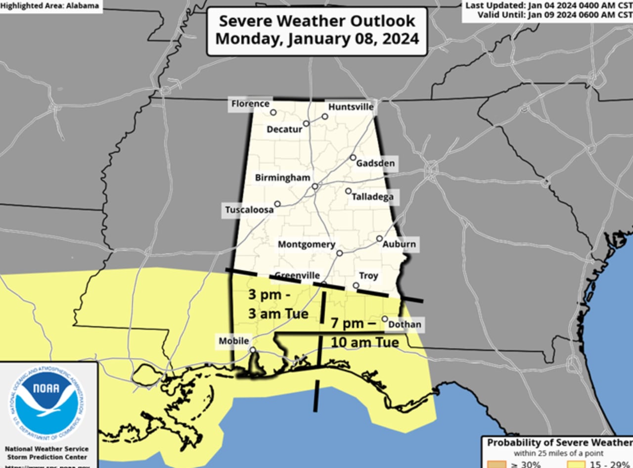
Stefkovich said a potent system with supercells and line segment storms will move across parts of the state Monday afternoon through Tuesday morning. Damaging winds gusts and tornadoes are expected in the southern portions of Alabama.
“This has the potential to become a significant event,” EMS said in a Thursday statement.
Storms are expected to start for the southwestern part of the state around 3 p.m. Monday and last until 2 a.m. Tuesday. The southeast corner of the state could see storms from 7 p.m. Monday – 10 a.m. Tuesday.
The latest threat is moving further inland from the coast though changes to the risk level and area are expected to change.
Strong winds are also expected before and after the storms with gusts from 25-40 mph from late Monday afternoon through Tuesday afternoon. Widespread 2-4 inches of rain will fall and when combined with the totals from Friday into Saturday, localized flash flooding is possible, especially south of Hwy 80/I-85.
Showers are expected to end across the state by early Tuesday afternoon, though will likely continue north of I-20 into early Wednesday morning with a changeover to snow flurries or light snow possible in far north Alabama Tuesday evening.