Cold across Alabama; but a few storms may be coming
Alabama woke up to a very cold morning on Wednesday, with a least one area hitting the teens.
The National Weather Service expects cooler weather to hold on for at least one more day, but likely today will be the coldest morning of the week.
Here are a look at some unofficial overnight low temperatures from across Alabama. The coldest spot surveyed was Gadsden, which dropped to at least 18 degrees since midnight, according to weather service data. Below are the lowest temperatures observed overnight from midnight until 6 a.m. Wednesday:
Alexander City: 26
Anniston: 21
Auburn: 26
Birmingham: 26
Decatur: 20
Demopolis: 27
Dothan: 30
Eufaula: 26
Evergreen: 27
Gadsden: 18
Greenville: 25
Haleyville: 20
Huntsville: 23
Mobile: 32
Montgomery: 26
Muscle Shoals: 22
Sylacauga: 24
Troy: 28
Tuscaloosa: 26
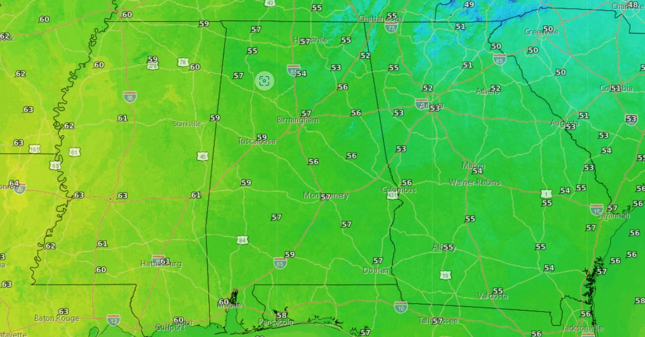
Chilly temperatures will hold on today, with highs expected to climb only into the 50s in most of Alabama with maybe a 60-degree reading in a spot or two. Here are the forecast highs for today (Wednesday):
Here are the forecast high temperatures for Wednesday.NWS
Wednesday night into Thursday morning will again be cold, but not as cold as the previous two nights, according to weather service forecasts. Expect lows in the 30s across most of the state with 40s on the coast. Here is the low-temperature forecast for tonight:
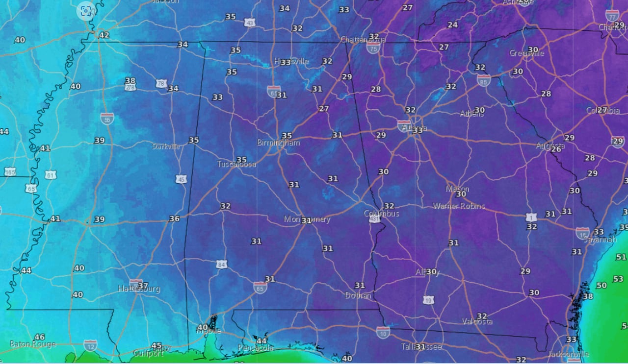
Here are the forecast lows for tonight (Wednesday night into Thursday morning).NWS
Thursday will see a shift to winds more out of the southwest, which will help to bring temperatures back up some and raise humidity levels.
A storm system will enter the picture on Friday, and NOAA’s Storm Prediction Center has added a Level 1 out of 5 risk for severe storms for much of south and parts of central Alabama on Friday (see the map at the top of this post).
A Level 1 threat means isolated severe storms will be possible. Weather service forecasters added that at this point it appears to be a low-end severe weather risk. Keep an eye on the forecast for Friday in case that changes.
The weather pattern turns wetter starting on Thursday night, and several inches of rain will be possible from Thursday through at least Sunday, according to the weather service.
Computer models have backed off some on potential rain totals from previous forecasts, but the weather service said 4 or more inches of rain will be possible for parts of Alabama through the weekend.
Here’s the five-day precipitation outlook from NOAA’s Weather Prediction Center. It shows the axis of the heaviest rain shifting to the southeast, and lower rainfall totals than in previous forecasts:
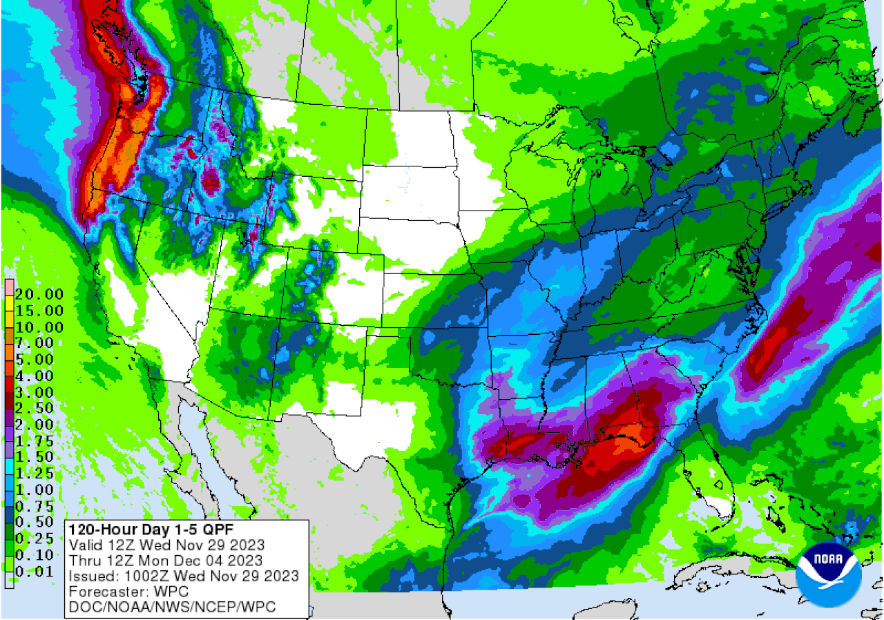
Here is the precipitation outlook for the next five days.Weather Prediction Center
The rain is expected to be on and off, but the wettest day is expected to be on Saturday, according to forecasters.
Drier weather is expected next week.