Tornado count from Saturday up to 9 in south Alabama
At least nine tornadoes hit southwest Alabama during a round of severe weather last Saturday, Oct. 29.
The National Weather Service in Mobile added two more tornadoes to the count recently after initially confirming seven twisters.
The two additional storms were both in Baldwin County. Both were EF-0s on the Enhanced Fujuita Scale.
Here’s a look at the two most recently confirmed storms:
* Skunk Bayou tornado: EF-0, top winds 85 mph. Path length 0.5 miles; path width 20 yards. No injuries. The tornado touched down on Saturday (Oct. 29) at 5:10 p.m. likely south of County Road 49 in Skunk Bayou. It moved north, damaging trees. It flipped a chicken coop and destroyed a barn just west of Carver Road. A travel trailer also had windows broken by debris on Carver Road. The tornado likely lifted just north of County Road 49.
* Daphne tornado: EF-0, top winds 80 mph. Path length 0.6 miles. No injuries. The tornado touched down at 9:19 p.m. south of Daphne Avenue, where some trees were damaged. The tornado crossed Daphne Avenue and downed several bigger trees. Then it crossed Randall Avenue and tore some shingles off a roof before lifting north of the area.
Here are the other tornadoes previously confirmed by the weather service:
1. Daws tornado (Mobile County): EF-1, peak winds 90 mph. Path length 4.9 miles; path width 250 yards. No injuries. The tornado touched down at 6:40 p.m. Saturday in a field to the southwest of the Pecan Terrace subdivision and damaged trees and a fence as it crossed Old Pascagoula Road. The storm moved across open fields for about 1.5 miles and then hit the Labrador Trail subdivision, significantly damaging fences and some roofs and sheds. Some damage was also noted along Dawes Oak Drive, including one home that had two windows blown in and roof damage, which prompted the EF-1 rating. The tornado likely lifted near Dawes Lane.
2. Orchard tornado (Mobile County): EF-0, peak winds 81 mph. Path length 2.5 miles; path width 180 yards. No injuries. The tornado touched down at 7:15 p.m. Saturday near Orchard along Lucerne Drive, damaging trees and fences. It moved north-northeast and crossed Overlook Road and then Howells Ferry Road and along Grider Road, where damage to sheds and homes was noted. One home near Rose Hill land had some roof damage with tree damage nearby. The tornado likely lifted around Moffett Road.
3. Magnolia Springs tornado (Baldwin County): EF-1, top winds 100 mph. Path length 0.50 miles; path width 40 yards. No injuries. The tornado touched down at 5:16 p.m. likely in a field southest of County Road 49 south of Bay Road East. The tornado snapped some wood power poles along Bay Road East and likely lifted as it crossed the road.
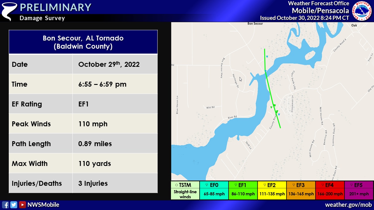
4. Bon Secour tornado (Baldwin County): EF-1, top winds 110 mph. Path length 0.888 miles; path width 110 yards. Three injuries. The weather service did an additional survey on this tornado and determined it likely began at 6:50 p.m. Saturday as a waterspout over Oyster Bay and then crossed Oyster Bay Road. It then tracked through a wooded area southeast of County Road 6 and headed northeast, taking most of the roof off a barn and snapping tree branches. It strengthened as it crossed the road and uprooted several trees. It peaked in intensity north of County Road 6 and destroyed a mobile home, causing minor injuries to three people inside. The tornado continued northeast, crossing the Bon Secour River and causing minor damage to a construction site. It lifted shortly after that.
5. Point Clear tornado (Baldwin County): EF-0, top winds 85 mph. Path length 0.02 miles; path width 20 yards. No injuries. The tornado touched down at 8:51 p.m. off Scenic Highway 98 by James Lowe Land in southwestern Baldwin County. It toppled a tree, shifted a carport off its holding blocks and shifted a loaded trailer about 20 feet.
6. Spanish Fort tornado (Baldwin County): EF-1, top winds 90 mph. Path length 0.257 miles; path width 20 yards. No injuries. The tornado touchd down at 9:29 p.m. near or just southwest of Waites Lane. It lifted briefly then touched down again to the northeast after crossing Spanish Fort Boulveard and moving to City Hall property. It snapped a few treets before heading futher northeast.
7. Brookley Field tornado (Mobile County): EF-0. The weather service said more information will be available on that tornado later this week.