Hurricane Lee path turns north; will it affect the US?
Hurricane Lee remained a Category 3 hurricane with 120 mph winds on Monday morning as it tracked slowly to the northwest.
The National Hurricane Center expects Lee to remain a strong hurricane through the week and slow down on its path to the northwest. That is expected to spare the Leeward Islands and Puerto Rico as well as the southeast U.S. coast.
Bermuda and, possibly, the Northeast U.S. will have to continue to keep an eye on the storm, however.
Bermuda is in the forecast cone, which shows where the center of the storm could go. The hurricane center thinks Lee will pass by the island to the west on Friday.
The hurricane center continues to forecast Lee to turn more to the north this week, but when that turn happens is still not set in stone. A turn farther to the west could bring some storm effects close to the New England coast by next weekend or later.
Lee is also expected to get a lot bigger, which means wind and rain from the storm could reach farther from the center.
The hurricane center continued to stress that it’s still too soon to speculate on that impact Lee could have on the U.S., aside from rough surf and rip currents along the East Coast.
“It remains too soon to know what level of impacts, if any, Lee might have along the U.S. East Coast and Atlantic Canada late this week, especially since the hurricane is expected to slow down considerably over the southwestern Atlantic,” the hurricane center said Monday. “Regardless, dangerous surf and rip currents are expected along most of the U.S. East Coast this week as Lee grows in size. Users should continue to monitor updates to the forecast of Lee during the next several days.”
As of the last update, at 4 a.m. CDT Monday, the center of Hurricane Lee was located about 650 miles south-southeast of Bermuda and was tracking to the northwest at 7 mph.
Lee had sustained winds of 120 mph, making it a Category 3 hurricane. Lee peaked last week as a Category 5 storm with top winds of 165 mph. It could strengthen more, forecasters said, and become a Category 4 hurricane again in the next 24 hours or so.
Lee is churning up waves and dangerous rip currents that are expected to affect the U.S. East Coast, the northern Leeward Islands, the Virgin Islands, Puerto Rico, Hispaniola, the Turks and Caicos Islands, the Bahamas and Bermuda through much of the week.
TROPICAL STORM MARGOT
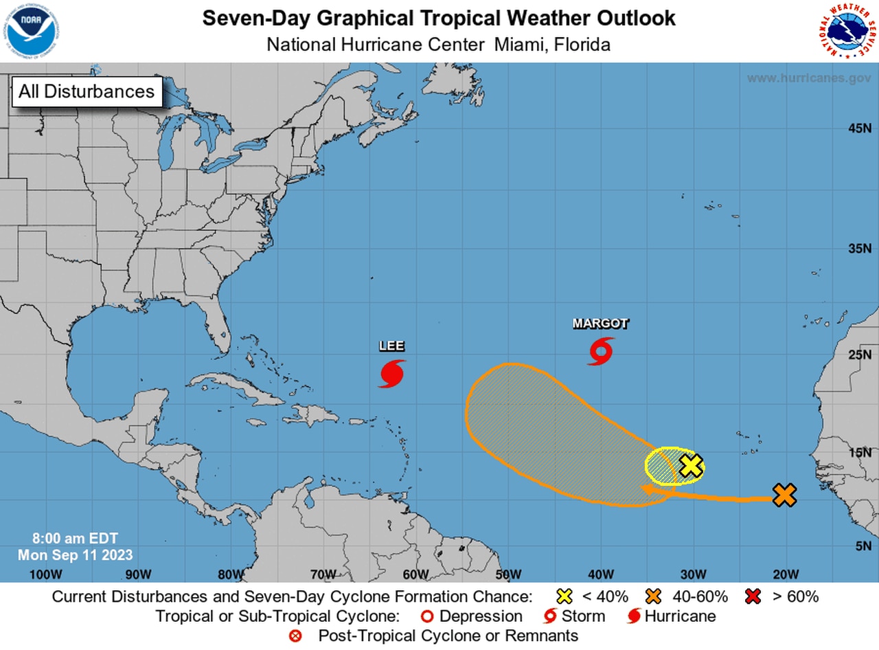
Tropical Storm Margot could become a hurricane soon.
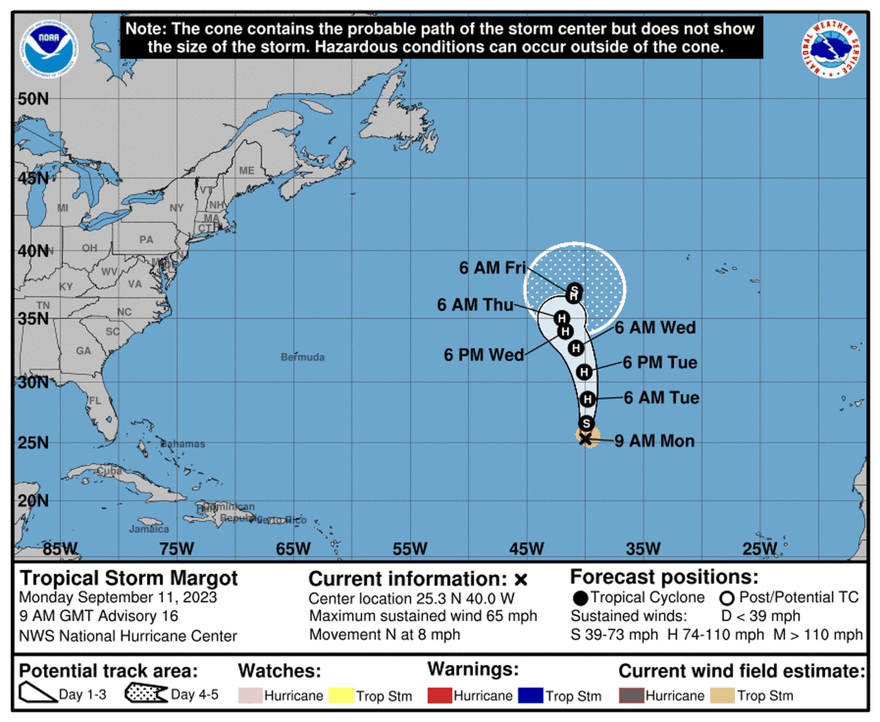
Tropical Storm Margot was holding onto 65 mph winds on Monday morning in the east-central Atlantic.
Margot is no threat to land but could become a hurricane soon. If it does it will be the Atlantic’s sixth hurricane so far in 2023.
As of 4 a.m. CDT Monday, Tropical Storm Margot was located 1,215 miles northwest of the Cabo Verde Islands and was moving northward at 8 mph.
The hurricane center said Margot is likely to become a hurricane tonight.
The hurricane center was also watching two other tropical waves that could merge this week as they head to the west-northwest.
The one expected to dominate could become a tropical depression by the end of the week, when it is expected to be in the central Atlantic, according to forecasters.

There are two tropical waves to watch in addition to Lee and Margot.
