Category 1 Idalia expected to strengthen more
Idalia strengthened to the third hurricane of 2023 in the Atlantic early Tuesday morning, and the National Hurricane Center said it is increasingly likely that a major hurricane will make landfall in Florida on Wednesday.
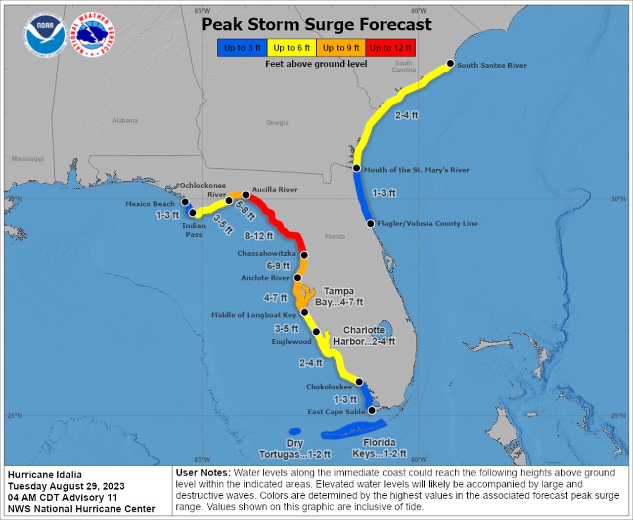
Idalia could bring 8 to 12 feet of storm surge, 120 mph winds and nearly a foot of rain to parts of Florida this week, according to forecasters. The National Weather Service told those in the storm’s path that preparations and evacuations need to be complete by sunset today.
Hurricane and storm surge warnings continued along Florida’s Gulf Coast on Tuesday.
The forecast path has been nudged a bit to the west but is relatively unchanged, with the center of the storm potentially making landfall Wednesday morning somewhere on Florida’s Gulf Coast in the Big Bend region. Winds, surge and rain will be felt far from where the center comes onshore, however.
The National Weather Service warned that there is still the potential for track shifts and those from the Panhandle to the peninsula should keep a very close watch on the forecast.
On the current forecast path Idalia (pronounced ee-DAL-ya) is expected to move across the eastern Gulf of Mexico today and reach the Gulf coast of Florida on Wednesday. It will then move over north Florida and south Georgia and into the western Atlantic and track close to the Carolina coastline on Thursday.
As of 7 a.m. CDT Tuesday, the center of Hurricane Idalia was located about 320 miles south-southwest of Tampa and was moving north at 14 mph.
Idalia winds increased to 80 mph, making it a Category 1 hurricane. The hurricane center warned that rapid intensification will be possible today over the record-warm waters of the Gulf of Mexico, and Idalia could be at Category 3 strength (winds starting at 111 mph) by the end of today.
The hurricane center’s intensity forecast suggests Idalia could peak with 120 mph winds before making landfall.
Idalia is expected to be a powerful Category 3 hurricane when it makes landfall in Florida on Wednesday.
Forecasters are particularly worried about storm surge, which is forecast to be as high as 8 to 12 feet along parts of the Florida Gulf Coast. Here is the storm surge forecast:
Parts of the Florida coast could see up to 8 to 12 feet of surge from Idalia.
Here are the watches and warnings as of Tuesday:
* Storm Surge Warning from Englewood, Fla., northward to Indian Pass, including Tampa Bay.
* Hurricane Warning from middle of Longboat Key northward to Indian Pass, Fla., including Tampa Bay.
* Tropical Storm Warning for the Dry Tortugas in Florida, from Chokoloskee, Fla., northward to the Middle of Longboat Key, from west of Indian Pass, Fla., to Mexico Beach and on the Atlantic coast from Sebastian Inlet, Fla., to Altamaha Sound, Ga.
* Storm Surge Watch from Chokoloskee, Fla., northward to Englewood, including Charlotte Harbor, and from the mouth of the St. Mary’s River to South Santee River, S.C.
* Hurricane Watch from Englewood, Fla., to the Middle of Longboat Key.
* Tropical Storm Watch is for Lower Florida Keys west of the west end of the Seven Mile Bridge and from Altamaha Sound northward to South Santee River, S.C.
The hurricane center also warned that a few tornadoes will be possible later today along the western part of the Florida peninsula. The tornado threat will spread northward into the Florida Big Bend by tonight.
HURRICANE FRANKLIN
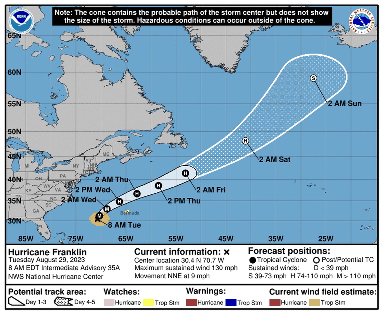
Hurricane Franklin is expected to pass well to the northwest of Bermuda on Wednesday.
Franklin remained a Category 4 hurricane on Tuesday morning as it tracked northward in the Atlantic. Franklin is expected to pass to the west of Bermuda on Wednesday, but it will come close enough that a tropical storm watch is in effect for the island.
The hurricane center said tropical storm conditions could be possible on the island starting on Wednesday morning.
Franklin is not a direct threat to the U.S. but will continue to cause dangerous rip currents and rough seas along the East Coast this week.
As of 7 a.m. CDT Tuesday, Hurricane Franklin was located 370 miles west-southwest of Bermuda and was moving north-northeast at 9 mph.
Franklin had sustained winds of 130 mph. Franklin peaked with winds up to 150 mph on Monday but is expected to continue to weaken as it heads northward.