Tropical Storm Emily forms but no threat; Gulf watched
There’s a new tropical storm in the Atlantic, the first since late July. But it’s not anything for those in the U.S. to worry about.
The National Hurricane Center said Tropical Storm Emily had formed in the central Atlantic on Sunday — but it was expected to be a short-lived storm that doesn’t affect land.
Forecasters also had their hands full with rare Tropical Storm Hilary in the eastern Pacific, which could bring devastating flooding to parts of the southwest U.S., as well as four systems in the tropical Atlantic that will need to be tracked.
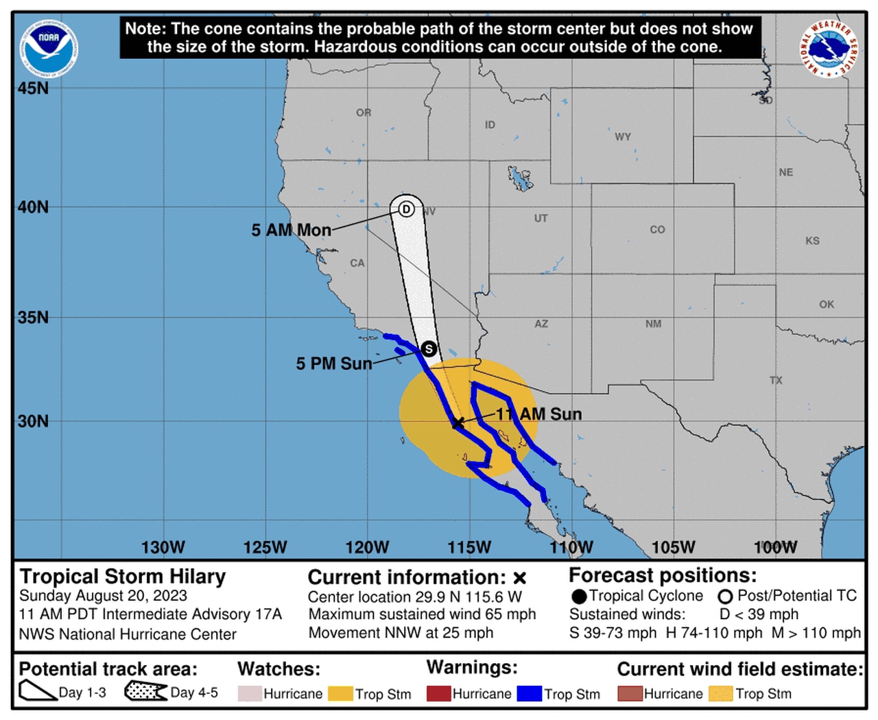
Hilary, once a Category 4 hurricane, made landfall as strong tropical storm on the northern Baja Peninsula in Mexico, and its center will track into southern California through this afternoon. Hilary could bring potentially catastrophic flash flooding to parts of the U.S. Southwest, which could see more rain in the next two days than it usually gets in a year.
Here’s the forecast track for Hilary:
Hilary has made landfall in northern Mexico.
The tropical system of most importance to those along the Gulf Coast was dubbed Invest 91, and the hurricane center said it could become a tropical depression in the next few days as it moves westward across the Gulf of Mexico toward the Texas coast, which could benefit from the rain.
Forecasters said rain and storms have increased with the system, which was in the eastern Gulf as of Sunday afternoon.
It’s expected to stay on a path westward at 15 to 20 mph and could approach the Texas coast by Tuesday.
It’s not expected to directly affect Alabama, but it will bring a high risk of deadly rip currents to Alabama and northwest Florida beaches on Monday and Tuesday, according to the National Weather Service in Mobile:
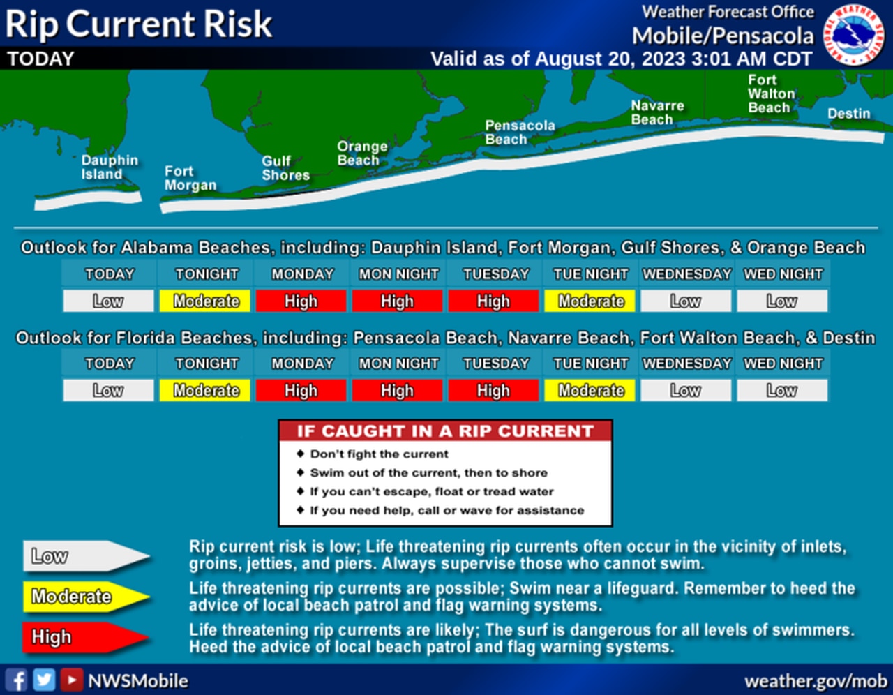
The risk of rip currents will increase to high on Monday and Tuesday off the Alabama coast.
Then there is Tropical Storm Emily, which is not expected to affect land. As of 10 a.m. CDT Sunday, Emily was located about 1,000 miles west-northwest of the Cabo Verde Islands and was tracking to the west-northwest at 10 mph.
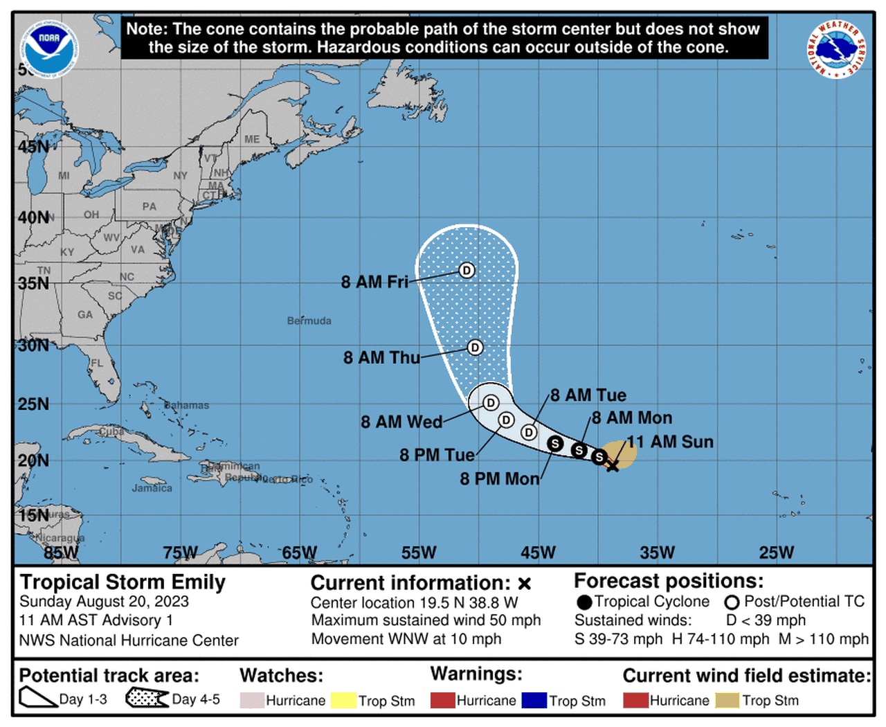
Tropical Storm Emily is expected to weaken and fall apart in the next few days.
Emily had winds of 50 mph, according to the hurricane center. Forecasters said little change in strength was expected today followed by gradual weakening. Emily is forecast to become a remnant low by Tuesday.
In addition to Emily there is Tropical Depression Six, which will not likely hang around long and won’t affect land.
As of 10 a.m. CDT Sunday, Tropical Depression Six was located 625 miles east of the northern Leeward Islands and was moving to the west at 12 mph.
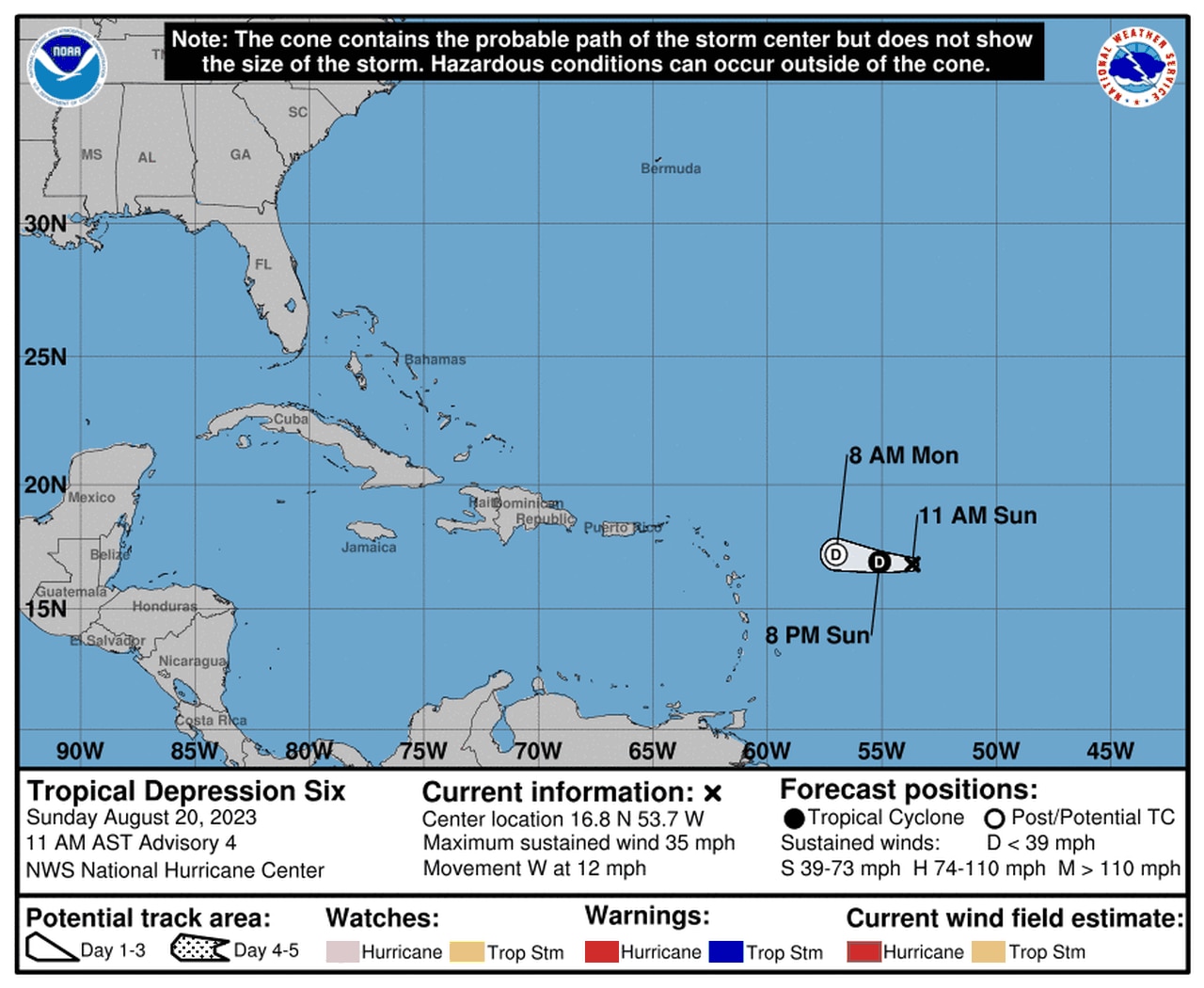
Tropical Depression Six could dissipate by Monday.
The depression had winds of 35 mph. The hurricane center said it should weaken and dissipate all together by Monday.
Another concern will be Invest 90, which could affect Hispaniola.
The hurricane center said signs point to a tropical depression forming in association with an area of low pressure in the eastern Caribbean. A NOAA Hurricane Reconnaissance mission was on its way to investigate the system as of Sunday afternoon.
The system is forecast to move to the westward or west-northwest at 10 to 15 mph over the Caribbean. Then it could turn north and affect the Dominican Republic and Haiti on Tuesday or Wednesday.
The hurricane center said tropical storm watches could become necessary later this afternoon for those areas.
If that wasn’t enough there was yet another tropical wave to contend with, but this one was far away in the eastern tropical Atlantic.
The hurricane center said a tropical wave southeast of the Cabo Verde Islands was disorganized as of Sunday afternoon. However, it was in a good area for development, and forecasters said a tropical depression could form later this week as the disturbance tracks to the west-northwest.
The tropics are busy, but that’s not unusual for this point in the season. The climatological peak of the Atlantic hurricane season is right around the corner on Sept. 10.
The next names on the 2023 Atlantic storm list are Franklin, Gert and Harold.
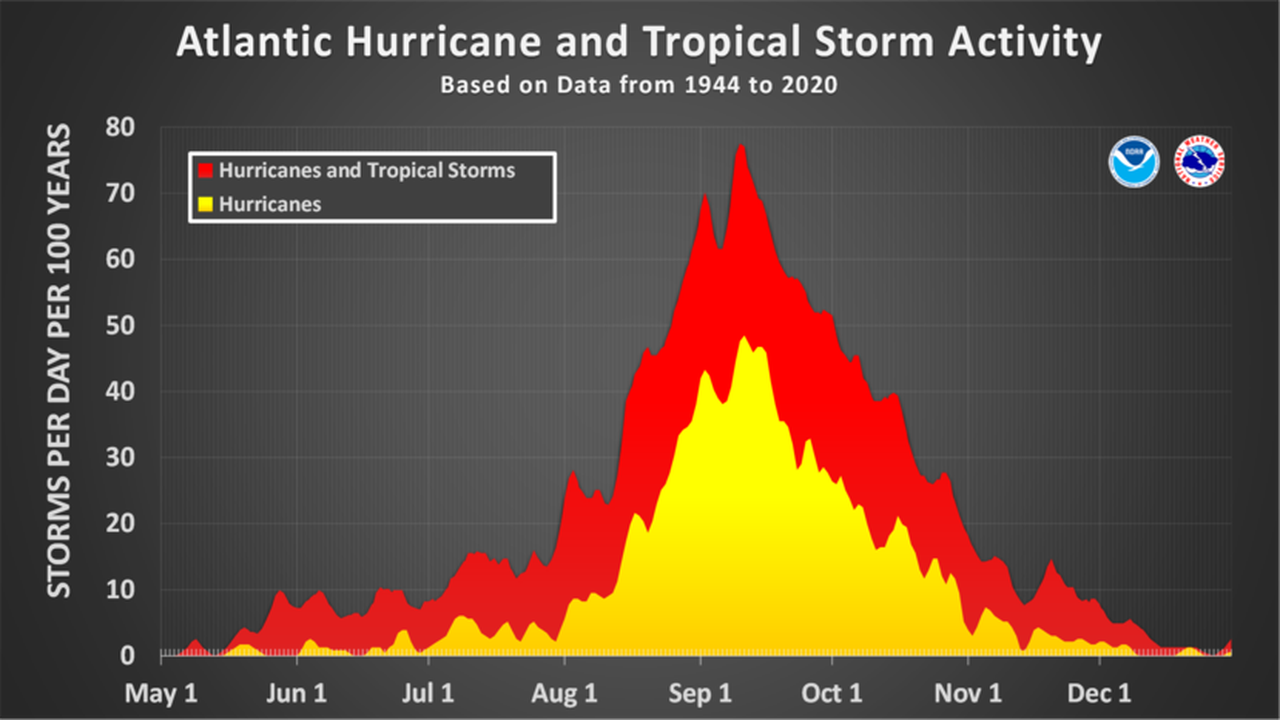
The Atlantic hurricane season typically peaks in September.
