California hurricane? No, but Hilary could come close
There’s a hurricane in the eastern Pacific, and it could make a rare impact on the state of California.
The National Hurricane Center upgraded Hilary to a hurricane on Thursday morning and said it could become a powerful storm soon while it churns off the Baja Peninsula of Mexico.
But Hilary is expected to track northward, and it is a very real possibility it could majorly affect the states of California and Arizona starting this weekend.
It wouldn’t be a hurricane at that point, however. Colder water in that part of the eastern Pacific would almost certainly weaken the storm, and the hurricane center is forecasting it to be a tropical storm with winds around 60 mph as it nears landfall on the northern part of the Baja Peninsula by late Sunday or early Monday.
But that’s just a few miles away from the southern California and Arizona borders.
Tropical storms can be wide-ranging systems and can spread heavy tropical downpours and gusty winds miles from where the center comes onshore — and if the current forecast path holds that could put parts of the Southwest U.S. in line for some major weather, according to forecasters.
The hurricane center said hurricane-force winds extended outward up to 70 miles from the center of Hilary on Thursday, and tropical-storm-force winds extended outward up to 275 miles.
As Hilary strengthens that wind field could expand even more.
The hurricane center said Hilary “has the potential to bring significant impacts to the Baja California Peninsula and portions of the southwestern United States this weekend and early next week, including after it becomes post-tropical.”
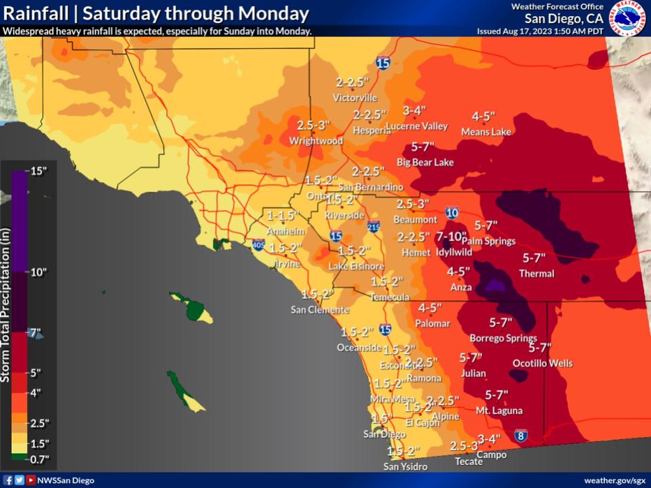
The National Weather Service in San Diego was keeping a close eye on Hilary on Thursday and said the storm could “bring a significant surge of monsoonal and tropical moisture with widespread heavy rainfall, especially for Sunday into Monday, and a high potential for flash flooding in the mountains and deserts.”
As of 7 a.m. CDT Thursday, the center of Hurricane Hilary was located about 560 miles south-southeast of Cabo San Lucas, Mexico, and was tracking to the west-northwest at 13 mph.
Hilary had winds of 75 mph, making it a Category 1 hurricane. The hurricane center’s intensity forecast shows Hilary peaking with 130 mph winds in about 48 hours. That would make it a Category 4 hurricane.
Tropical storm watches were in effect for parts of Mexico’s Pacific coast.
The hurricane center said Hilary could turn toward the northwest by Friday morning, followed by a turn toward the north-northwest and north on Saturday. On that track, the center of Hilary will approach the Baja California peninsula over the weekend.
It’s been a while since California had to deal with a hit from a tropical system.
According to The Los Angeles Times the last storm to impact the Golden State — which has been called El Cordonazo — struck Long Beach in September of 1939. According to The Times almost four dozen people died and about the same number were reported lost at sea.
Here’s the rainfall forecast from the National Weather Service for southern California:
Hurricane Hilary could bring a lot of rain to parts of California and Arizona over the weekend, raising the potential for deadly flash flooding.
Here is what forecasters were watching with Hilary:
The hurricane center will update the forecast for Hilary throughout the coming days, so stay tuned for track updates.
