Alabama heatwave: Officials say heat index may hit 118
The Alabama heatwave will begin to affect more of the state today, and the National Weather Service said the heat index could climb as high as 117 in some areas before it’s over.
Excessive heat warnings will be in effect today (Wednesday) for parts of south Alabama, and more be activated on Thursday into Friday as triple-digit temperatures affect more of the state. (See all the warnings and advisories below.)
The National Weather Service said an area of high pressure that has been pumping up temperatures across parts of the South will shift eastward and turn up to heat in Alabama through at least Saturday.
South Alabama will be the hottest today, and excessive heat warnings will be in effect for several areas thanks to the combination of heat and humidity.
Thursday and Friday are expected to be the hottest days for most of the state, when many areas have a good chance of hitting 100 degrees.
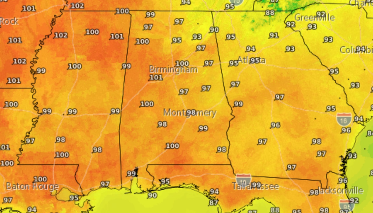
Here is the air temperature forecast for Thursday:
Many areas could hit 100 degrees on Thursday.
And here’s the forecast for Friday:
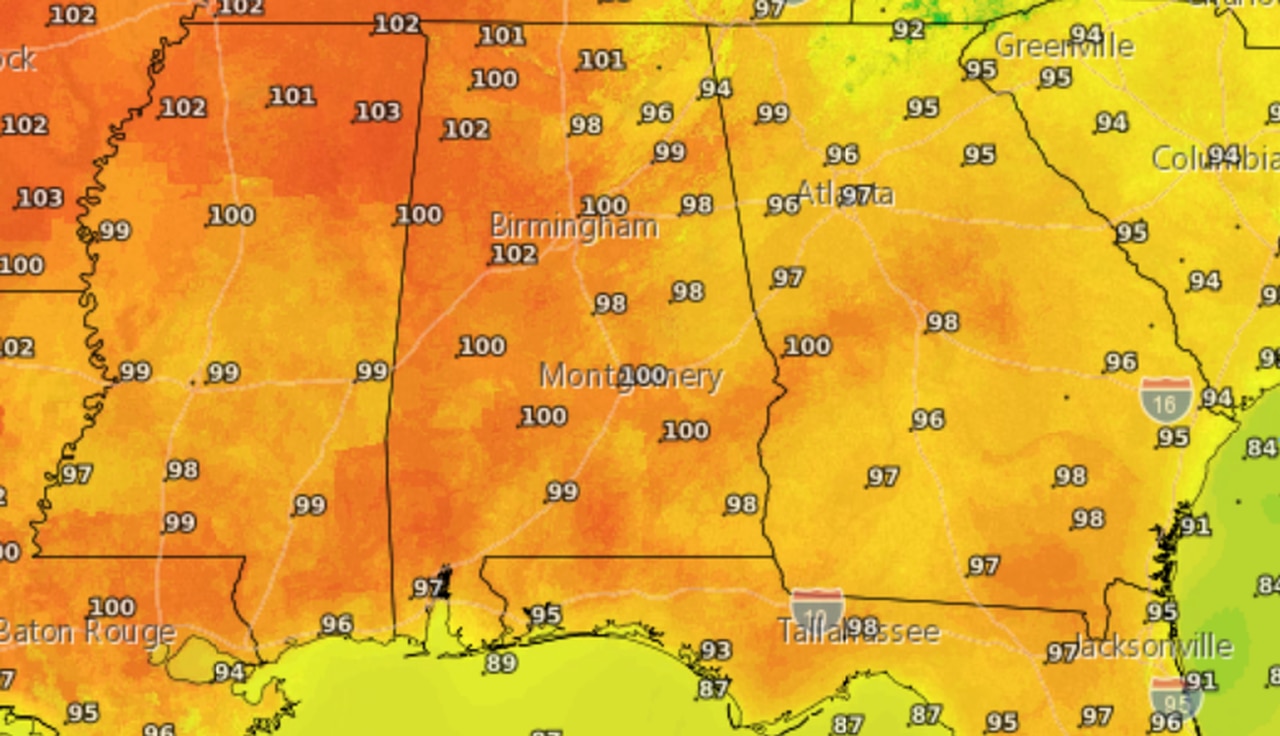
Triple-digit temperatures will continue into Friday.
And that’s just the air temperature. Combine that with higher humidity levels and that could result in heat index values, or the “feels like” temperature, of 110 or higher through Friday.
The National Weather Service is saying the heat index could be as high as 117 in parts of Alabama before the weekend is over.
Rain chances won’t be zero but will be on the low side through Saturday, however forecasters will be watching to the west in case storm complexes expected to move through Mississippi and Louisiana could make it far enough east to affect Alabama. That wasn’t looking as likely as of Wednesday morning.
Forecasters also warn that temperatures aren’t expected to cool off as much during the overnight hours, which could compound the effects of extreme heat.
Alabamians are cautioned to stay in air conditioning or shade, drink lots of water and not leave kids or pets alone in cars.
There is a slight break in sight: The weather service expects the heatwave to ease and temperatures to return closer to normal by the first of next week.
Alabama is covered by a slew of excessive heat warnings and heat advisories from today through Friday. Here’s a look at them by region.
SOUTH ALABAMA
* Excessive heat warning for Mobile and Baldwin counties from 11 a.m. until 7 p.m. Wednesday. Heat index values up to 115 will be possible today in those areas.
* Heat advisory for Washington, Clarke and Escambia counties from 11 a.m. until 7 p.m. Wednesday. Heat index values up to 108 will be possible today.
* Excessive heat watch for Mobile and Baldwin counties from Thursday morning through Thursday evening. Heat index values up to 115 will be possible on Thursday in those areas.
* Excessive heat watch for Washington, Clarke and Escambia counties from Thursday morning until Thursday evening. Heat index values up to 113 will be possible Thursday.
* Excessive heat watch from Thursday morning until Thursday evening for Choctaw, Wilcox, Monroe and Conecuh counties. Heat index values up to 113 will be possible in those areas.
CENTRAL ALABAMA
The heat advisories for central Alabama include excessive heat warnings for Thursday and Friday and heat advisories for Thursday and Friday for different regions.
* Excessive heat warning from 11 a.m. Thursday until 9 p.m. Friday for Marion, Lamar, Fayette, Winston, Walker, Blount, Pickens, Tuscaloosa, Jefferson, Shelby, Sumter, Greene, Hale, Perry, Bibb, Chilton, Marengo, Dallas, Autauga, Lowndes, Elmore and Montgomery counties. Heat index values could top 110 in those areas, according to the National Weather Service.
* Excessive heat warning from 10 a.m. until 9 p.m. Friday for St. Clair, Talladega and Coosa counties. Heat index values could top 110 on Friday in those areas.
* Heat advisory from 11 a.m. Thursday until 10 a.m. Friday for St. Clair, Talladega and Coosa counties. Heat index values between 105 and 110 are expected.
* Heat advisory from 11 a.m. Thursday until 9 p.m. Friday for Etowah, Calhoun, Cherokee and Tallapoosa counties. Heat index values up to 110 will be possible in those areas.
* Heat advisory from 10 a.m. until 9 p.m. Friday for Cleburne, Clay, Randolph, Chambers, Macon, Bullock, Lee, Russell, Pike and Barbour counties. Heat index values up to 109 will be possible.
NORTH ALABAMA
* Excessive heat warning from 11 a.m. Thursday until 8 p.m. Friday for Lauderdale, Colbert, Franklin, Lawrence, Limestone, Madison, Morgan and Cullman counties. Heat index values up to 117 will be possible, according to the National Weather Service.
* Heat advisory from 11 a.m. Thursday until 8 p.m. Friday for Marshall, Jackson and DeKalb counties. Heat index values up to 109 will be possible in those areas.