Two tropical storms in the Atlantic now: Bret and Cindy
The National Hurricane Center was tracking not one but two tropical storms on Friday.
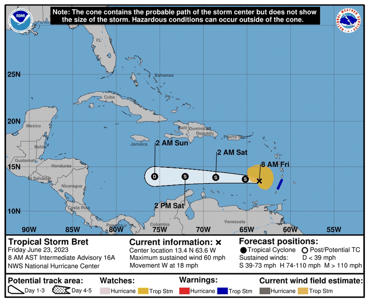
Tropical Storm Bret has moved into the Caribbean Sea after passing through the Windward Islands overnight and is expected to weaken and dissipate over the weekend, according to the National Hurricane Center.
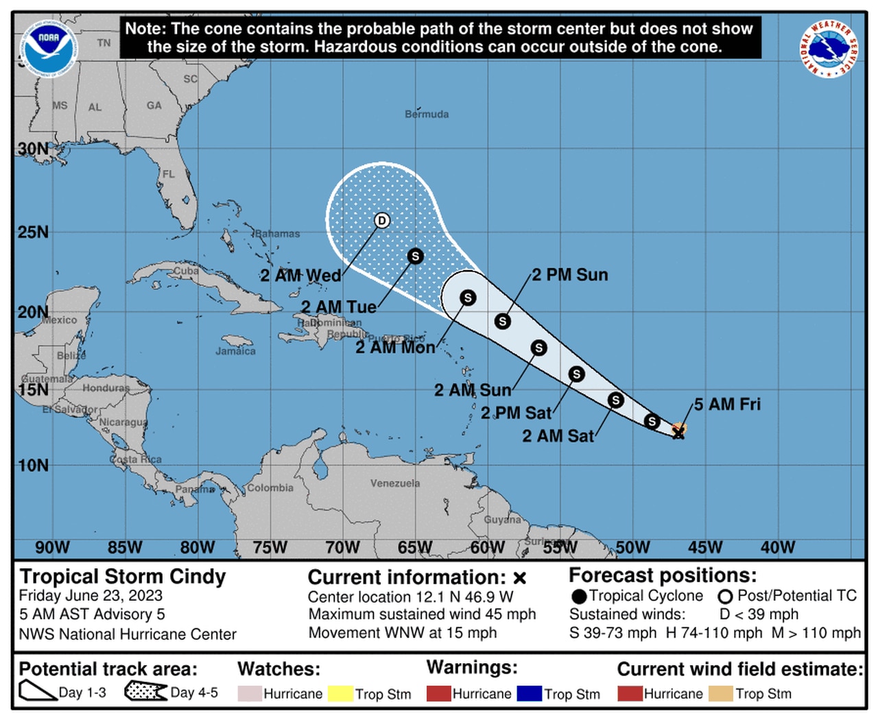
To the east of Bret in the central Atlantic Ocean is Tropical Storm Cindy, which formed late Thursday and was getting stronger on Friday as it headed northwest. Cindy is expected to miss the Lesser Antilles and also weaken next week.
Neither storm is expected to become a hurricane, and neither is a threat to the United States.
But both formed far to the east of where tropical systems get going at this point in the season, so hurricane watchers were speculating on that that means for the rest of the season.
TROPICAL STORM BRET
Tropical Storm Bret was moving away from the Windward Islands and into the Caribbean on Friday and had 60 mph winds. It peaked just under hurricane intensity on Thursday with 70 mph winds.
As of 7 a.m. CDT Friday, Tropical Storm Bret was located about 160 miles west of St. Vincent and was moving west at 18 mph.
Tropical Storm Bret is forecast to weaken and dissipate over the weekend in the Caribbean.
A tropical storm warning continued for St. Vincent and the Grenadines, but the warnings had been dropped for the rest of the Windward Islands on Friday morning.
The hurricane center said Bret will continue tracking to the west — away from the islands — and deeper into the Caribbean over the next few days. It was expected to stay well to the south of Puerto Rico and Hispaniola.
Wind shear is forecast to increase in that area, and Bret is expected to weaken and dissipate in the Caribbean over the weekend, according to the hurricane center.
Bret could still bring some rain to the islands, and forecasters said a storm total of 3 to 6 inches will be possible from Guadeloupe south through St. Vincent and the Grenadines, including Barbados.
TROPICAL STORM CINDY
Tropical Storm Cindy could get a bit stronger but is not expected to become a hurricane. It should become a non-tropical system by mid-week.
Far to the east of Bret is the newest Atlantic tropical system, Tropical Storm Cindy.
As of 4 a.m. CDT Friday, Tropical Storm Cindy was located about 990 miles east of the Lesser Antilles and was on a path to the west-northwest at 15 mph. (There are no watches or warnings in effect for Cindy, so updates on it are not as frequent.)
Cindy got a little stronger overnight and had winds of 45 mph. It was still a minimal tropical storm. The hurricane center said some strengthening will be possible over the next few days, but Cindy is not expected to become a hurricane.
The hurricane center said that if Cindy stays on the forecast track it should remain well east and northeast of the northern Leeward Islands through early next week.
The long-range track for Cindy shows it weakening to a depression and then a non-tropical system by Wednesday, when it could be somewhere between the Bahamas and Bermuda.
There are no other potential storms brewing in the Atlantic as of Friday.
The Atlantic hurricane season began June 1 and ends Nov. 30.
A near-average season is predicted by NOAA, with 12-17 named storms, five to nine hurricanes and one to four major hurricanes (Category 3 or stronger storms.)