Severe weather possible in Alabama starting Wednesday
Enjoy Tuesday’s relatively dry weather, because three days of storms will be possible in Alabama starting on Wednesday, according to the National Weather Service.
Tornadoes, damaging winds, hail and heavy rain will all be possible with the strongest storms during those three days.
The National Weather Service noted that it will also be very windy, and power outages are a real possibility Thursday into Friday for parts of the state, both from severe storms and very windy conditions outside of storms.
NOAA’s Storm Prediction Center has parts of Alabama in a severe weather risk on Wednesday, Thursday and Friday, with Thursday night into Friday morning possibly being the busiest period.
There will be a Level 1 out of 5 risk for severe weather for most of north and central Alabama on Wednesday. A Level 1 risk means that isolated severe storms will be possible. (See Wednesday’s storm outlook at the top of this post.)
Wednesday’s storms will be the most likely during the afternoon and evening hours.
The strongest storms could have wind gusts up to 60 mph and large hail.
The weather service is expecting a warm front to move northward from the Gulf Coast and spread warmer, moist air over Alabama. That could set the stage for storms during the peak heating of the day — although storms are not a sure thing, the weather service said.
Forecasters in north Alabama will also be watching closely on Wednesday night into Thursday morning in case flooding becomes a concern for north Alabama, which could see multiple rounds of rain, according to the weather service.
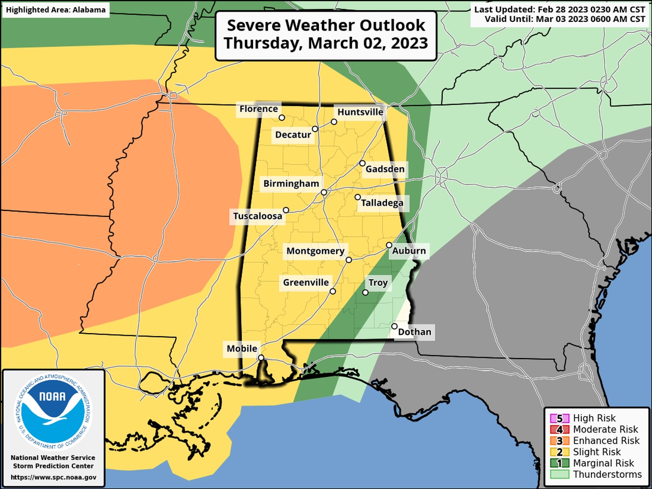
On Thursday night into Friday morning there will be a Level 2 severe weather risk for most of the state except the southeast corner as a cold front approaches from the west.
A Level 2 risk means that scattered severe storms will be possible.
Those storms could also contain tornadoes, damaging winds and hail, with west Alabama having slightly higher probabilities of seeing strong storms.
The weather service also noted in Tuesday’s forecast discussion that power outages will be possible from both severe storm gusts and strong non-thunderstorm winds.
The weather service said that the timing of the Thursday-Friday storms still needs refining and has slowed down in recent model forecasts.
The weather service expects to see a quick-moving line of storms move through Alabama from west to east, likely starting late Thursday or early Friday morning in west Alabama and lasting into the day on Friday in east Alabama.
Here is the severe weather risk for Thursday night into Friday (this outlook spans from Thursday until 7 a.m. Friday):
Much of Alabama will have a Level 2 out of 5 risk for severe weather from Thursday night into Friday morning.
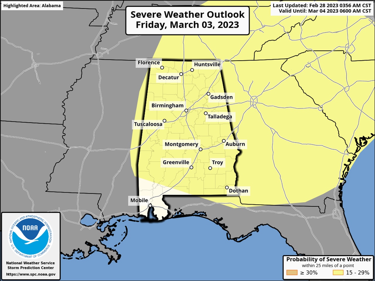
And the risk of severe weather will last into the day on Friday for much of Alabama. Here is Friday’s severe weather outlook (which begins at 7 a.m. Friday):

The risk for severe weather will last into the day on Friday for much of Alabama.
It could also be very windy — even away from the storms — on Thursday into Friday, according to the weather service.
Cooler, calmer and drier weather is expected to take over by the weekend, with no severe weather expected going into next week.
Saturday could be a cooler day than Alabama has experienced recently, with highs in the 50s and 60s expected in north and central Alabama and 70s in south Alabama.
Forecasters expect temperatures to begin to increase again starting on Monday into next week.
